National Geographic August 2015, Part 2

Last Rites for the Jade Sea? by Neil Shea, photographs by Randy Olson

Last Rites for the Jade Sea? is about Lake Turkana, which sits on the border between Kenya and Ethiopia, and the Daasanach people, who depend on the lake for their livelihoods. Lake Turkana sits not terribly far from the Great Rift Valley, where humanity began, and the ancestors of modern humans lived on its shorelines.

And, as with so many smaller bodies of water, Lake Turkana is threatened. The lake has been shrinking for 7,000 years. The trend has increased in recent years, and may be threatened further by a proposed dam and planned sugar plantations on the Omo River. The Omo River is the main river that feeds Lake Turkana. Sugarcane uses a lot of water and the dam will certainly not help the flow of water to the lake.

The Daasanach are underrepresented in Kenya’s government and so it is likely that their concerns, and their very homes, may never be taken into account as the governments of Ethiopia and Kenya make plans for the Omo River and the region around the lake.

Still Life, by Bryan Christy, photographs by Robert Clark

Christy takes us to the World Taxidermy Championships in St. Charles, Missouri, and then further into the history of taxidermy. My interest in taxidermy is superficial at best. I have many fond memories of the taxidermied animals at the Field Museum of Natural History (likely to come to a Northern Illinois Destination post near you sometime in November). The Field Museum has the skins of the lions that were the subject of the movie “The Ghost and the Darkness.” One lion is kind of standing up and the other is lying on some rocks. If you’ve been through that room, you have probably seen them. They now have a big sign and everything, though I don’t think they had that sign when I was younger.The lions are smaller than they were in life because they were used as rugs for 25 years in the home of the man who killed them (and who was played by Val Kilmer in the movie), and they were in the kind of shape that you’d expect a 25-year-old fur rug to be. As a result, the taxidermists had to trim them down to make it work.

Then there’s Jenny Lawson. Her blog, The Bloggess, is about Lawson’s life and mental illness and the weird and wonderful things that happen in her life. Lawson also collects taxidermied animals. Her rules for her collection are that the taxidermy has to be older than she is, or that the animal has to have died of natural causes. And despite this, she has amassed a really amazing collection of taxidermy animals.

So, overall, this was a pretty interesting read. Though sharing my home with the skin of dead animals which has been wrapped around a plastic form so that it looks like the animal might have looked in life isn’t really a goal of mine.

Laos Finds New Life After the Bombs, by T.D. Allman, photographs by Stephen Wilkes

I’m going to level with you. I’m a pacifist. I don’t know if I’m gung-ho enough to join the Quakers or Mennonites (there’s a part of me that goes, “well, maybe, I guess . . ” about the American Revolution, the Civil War and World War II*), but in general, I’m anti-war.

And I cut my teeth on this anti-war stance at a surprisingly young age. I can’t remember a time when I thought that the Vietnam War was a good idea. Now as a sort of side comment, by the time I was born, the war was about halfway done. I also became aware of the wider world outside as it became more clear that the Vietnam War had been a colossal waste of time, money, and, most importantly, of lives.

One of the worst-hit victims of the Vietnam War was Laos. As the tagline for the article says, “the U.S. dropped more than 2 million tons of bombs on Laos . . . . That’s equal to a planeload every 8 minutes for 9 years.” I was on the low end of the single digits for most of that time (and wasn’t even there for some of it), but that statistic makes me feel kind of ill.

In 2015, it has been over 40 years since the bombs stopped falling and the Laotians are still feeling the effects of the war. Their ground is still full of holes from where the bombs landed and they still find live bombs. In the nine years from 1999 through 2008, 1,350 people were injured and 834 were killed when old bombs exploded. Taking those numbers as an average (rather than, as I suspect, a low end), that’s about 3,800 deaths from when the bombing ended to today, and that’s 3,800 too many.

Allman’s words and Wilkes’s photographs do a wonderful job of not only showing the damage done but also showing how Laos has grown, and will continue to grow, over the intervening years.

*There are probably other wars in other countries that I would say the same about, but as I’m not very interested in war, finding those wars is not a priority for me.

Looking to the Future

Now that I’m down to actual identifiable years in my travel, I did a quick count of the places I can remember having traveled and the years I went.  It looks like I have enough My Travel Memories posts to get me through until April or May of 2017, not counting the month or so that I will spend on my 2016 vacation.  There might be more.  I have a gap from 1983 through 1986 and if we went anywhere then, I can’t remember it.  So if my dad can find my mom’s old travel journals, that may spark some new memories that I can use to fill in those years.

My plans for my 2016 vacation are Salt Lake City, Fishlake National Forest, the Golden Spike Monument, Yellowstone, and Dinosaur National Monument.  So that will be a little more than a month.

So then I would be in June or July of 2017, which is when I will be taking my 2017 vacation, which is looking to be The Netherlands and Germany (if all goes as planned financially).  That should take me through at least August and probably into September of 2017.   After that?  I don’t know.

And who knows?  Maybe this travel blogging thing will lose its luster by January and I’ll stop in the summer of 1982 or wherever I am by then.  But assuming I’m in this for the long haul (and I’ve been writing with one site since 2011, so I probably can stick this out at least that long), I will keep going at least through 2017.

As of 2017 I will have three weeks of vacation a year at my job.  So maybe, just maybe, I can fit in some smaller trips to new destinations in that extra time.  Maybe if Wild Earth Llama Adventures is still in business by then Alex and I can make a trip to New Mexico . . . .

My Travel Memories: Gettysburg, Pennsylvania

We took two non-North-Carolina-or-Florida trips in 1979.  I can’t remember which came first, though, and the photographs we have were all taken with a Polaroid SX-70, so they are completely undated.  So we’ll do the bigger trip first, and then move onto the smaller one later.

The bigger trip was Gettysburg, Washington, bits of Maryland (including Barbara Fritsche’s house), Williamsburg, and Jamestown.  Because of my parents’ thing about famous houses, we also fit Mount Vernon and Monticello (homes of George Washington and Thomas Jefferson, respectively) in on the trip. The order of that photo album has us going to Gettysburg, then the National Cemetery, then to Mount Vernon, then back to do the rest of D.C. and Monticello after Williamsburg and Jamestown, so that’s probably what I will do here.

Gettysburg, Pennsylvania is home to the aptly named Gettysburg National Military Park, which encompasses the battlefield, a national cemetery, assorted monuments, and a visitor’s center.  The visitor’s center is home to a museum, a “Cyclorama,” which is a circular panoramic painting, in this case, of the battlefield.

The Battle of Gettysburg, which was fought on July 1, 2, and 3, 1863, is thought of as the “turning point” for the Civil War.  Up until that battle, the Confederacy seemed to be doing pretty well, Gettysburg ended the Confederacy’s hopes of victory.  And, indeed, the war only went on for nine months and six days (by my count) after the Battle of Gettysburg ended. Gettysburg was the bloodiest battle of the Civil War, with over 50,000 casualties.

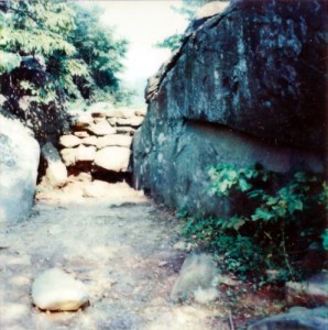
Devil's Den Gettysburg in 1979
The Devil’s Den, Gettysburg, circa 1979

We stayed in town in a hotel next door to the house where the only civilian casualty of the battle, Ginnie Wade, died.  Ginnie lived in the center of the town, and she had come to visit her sister on the outskirts of town at the time of the battle.  A bullet, either fired by a sniper, or a stray bullet from a nearby skirmish, passed through two doors and hit Ginnie, killing her instantly.   I looked at this area on Google Maps and I seem to recall more buildings in that area than there are today.

When we visited Gettysburg, there was an observation tower near the battlefield. The National Park has since seized the property under eminent domain laws and demolished the tower. The National Park Service apparently intends to restore the land to what it looked like in 1863, and since the tower had a very 1970s vibe to it (and, indeed, it could not have been built without access to computers to calculate the support necessary to build the tower with the minimum amount of steel), it had to go.  Ir’s kind of a pity, though.  The tower won an award from the American Council of Civil Engineers and was the subject of patent D227448.  The Visitors Center and Cyclorama have been razed and rebuilt in a more 1863-ish style since my visit, as well.  The new building looks more like a farmhouse and barn than the old building did.

National Geographic August 2015, Part 1

I don’t normally comment on the material that comes before the actual articles, but I will make an exception in this case. A few months back, I commented to one of my pharmacists that, if I ever get lice — which is doubtful, but you never know — there is a class of medications that I cannot take because of my hay fever. She had never heard of such a thing and my attempts to find the medication right then came to nothing.

This issue has the answer. The class of medications is ones that are based in pyrethrum. The little article-let thing is on the resurgence of pyrethrum production in Rwanda. Pyrethrum comes from certain species of chrysanthemum, so there is a possible cross-reaction in people with hay fever. The chrysanthemums in the photo, by the way, are single flowers, and not double, like the ones we generally see in the United States.

Generally, pyrethrin, and not pyrethrum, is sold for lice treatment in the United States. RID is one of these medications.

So there you have it. The only medical reason that I know of why I would need to disclose my hay fever when medical personnel ask me if I have any allergies to any medications.

Will the Pope Change the Vatican? Or Will the Vatican Change the Pope? by Robert Draper, photographs by Dave Yoder

During Alex and my 2014 trip to Italy, we went to the Vatican City. We spent three or four hours at the Vatican Museums and then walked around the city walls, the long way, to St. Peter’s Square. As we now (as I write this) live in the first time since the 15th century when there were two living Popes simultaneously, I realized that gave me double the usual chance to see a Pope when we were there and, despite being a dyed-in-the wool Protestant, I kind of hoped that we’d see one, and my preference was for Francis. Alas, we didn’t see even one Pope (though we saw two Swiss Guards who looked to be on-duty, which may indicate that a Pope was nearby).

Fortunately, Yoder didn’t have to look around, hoping to see a Pope. In fact, he was hired by National Geographic to follow the Pope for a six-month period (described in this issue as “off and on”) to take pictures of Pope Francis. Yoder took 67,000 pictures, some of which are reproduced here. Some of the others are in the book Pope Francis and the New Vatican, which came out in September of 2015.

The text of the article goes into some of Francis’s background, including his appearance at a convention of Roman Catholics and Evangelical Christians at which he asked the Evangelicals to pray for him, and for which the ultraconservative Catholic Argentinian newspaper Cabildo labeled him apostate.

Draper’s text also focuses on the changes that Pope Francis has made, from his more humble lifestyle to the attempts of his staff to keep up with his, to them, unpredictable personality. We also see some of the changes that the Papacy has made in Francis. He has accepted that he is now a public figure and has gotten over some of his camera-shyness. One of the changes that resonated with me, was that when he was just plain Jorge Mario Bergoglio, he liked to walk around in Buenos Aires, but he is no longer allowed to wander around Rome in the way he would like to do. The Pope would like to retire someday and return to his home in Buenos Aires. Whether he will be able to do so remains to be seen.

As to the shocking statements and some of the changes he has made, a Buenos Aires-based priest who has known Francis for decades says, “I believe we haven’t yet seen the real change. And I also believe we haven’t seen the real resistance yet either.”

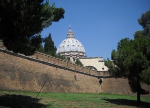
St. Peter's dome from outside the Vatican City
The dome of St. Peter’s Basilica from outside the Vatican City walls

South Texas Destinations: Museum Reach, the River Walk, San Antonio, Texas

While you are on the River Walk in downtown San Antonio, you will see occasional signs pointing north (well, generally north, I suspect there may be some that actually point east and will take you to a north/south part of the river, where the signs point north, and the river is not strictly straight, so some may point northeast or northwest) that say, “Witte Museum.” These signs will take you to the Museum Reach section of the River Walk.

The Museum Reach section is comparatively new. I remember one of my parents’ visits here in the 1990s my dad insisted on walking to the northern end of the River Walk.  At the time, the path ended near the Hugman Dam. The San Antonio River’s elevation changes pretty suddenly both just north and just south of downtown with the end result that the current was faster than Hugman would have liked for the gondolas that he envisioned traveling up and down the river.  So he put a dam in at either end of the River Walk.  The water would pool up a bit behind the dams and would slow down the flow of the water.  When they extended the River Walk to the north, they added a river taxi service and put an opening in the dam so that the boats can get through.

Anyway, back to the 1990s.  My dad wanted to keep walking, so we continued through the underbrush for another couple of blocks after the sidewalk ended. I don’t think we went as far as McCullough, though. All of that is area paved and landscaped now and it is unrecognizable from that scrubby bank that we walked along in the 1990s.

The Museum Reach section of the River Walk is designed for use by tourists, so as you go farther north, the River Walk passes several other destinations.  First is the new lock and dam that they built to take care of that elevation change and allow the boats to go on farther north on the river.  If you are so inclined, you can just stand on top of the dam for hours just watching the river boats being carried up and down in the locks.

Along the way towards our next destination, the San Antonio Museum of Art (must remember to bring these links back here once I make these posts.  If I never do, at least you will know that I meant to do so) you will find a public art installation called “Sonic Passage.” Sonic Passage is a sound-based installation, so there’s nothing to see, but it’s an interesting experience.

The Art Institute of Chicago, it is not, but the San Antonio Museum of Art, which is housed in the original Lone Star Beer brewery, has a lot going for it, including a very important, both regionally and nationally, collection of Asian art and most of the collection of Mexican folk art amassed by former Vice President Nelson A. Rockefeller.

Continuing farther north, we will go under Interstate 35, where you will see another art installation, ‘F.I.S.H.” F.I.S.H. is, just like the name implies, fiberglass fish.  The fish light up at night, as well. Past the bridge is another installation, the concrete “Grotto.” Another former brewery, the Pearl Brewery, is the next stop.  The Pearl Brewery was a working brewery until 2001 and was nearly razed after it closed.  The centerpiece of the brewery, the brewhouse, was built in 1894 in a sort of I guess Second Empire style.  Today the complex is home to a number of businesses, including restaurants, a hotel, and a farmer’s market that is held twice a week.  The Pearl Brewery also has 324 apartments, so it is not just a restaurant complex, it is also home to (at least potentially) 324 families.

And I was right.  The Pearl Brewery is Second Empire. I spent several days researching the Hugman Dam, and didn’t want to lose that kind of time on the architectural style of the Pearl Brewery.  So I basically thought, “It reminds me of Philadelphia’s City Hall.  What style is that?” And Philadelphia’s City Hall is Second Empire.  So when I searched for “Pearl Brewery” and “Second Empire” I found all kinds of pages that backed me up.

Not too far north of the Pearl Brewery, the sidewalk ends at a big concrete structure that looks kind of like a dam.  It isn’t a dam, however, it’s the flood control inlet.  There is a giant tunnel underneath downtown where extra water from potential flooding is channeled underneath the city so that potential flooding won’t become actual flooding and flood downtown (as we saw in the spring of 2015, the tunnel is not 100% effective). The water comes out south of downtown and we will see the outlet in my post on Mission Reach (once Alex and I finish walking that entire distance, which probably won’t be until winter sometime — it’s October and still hot here).

If you are looking at the flood control inlet and want to continue on farther north, you have to double back to the other side of the Josephine Street overpass and go up to street level.  The other side of Josephine Street is Flood Control Inlet Park.  At the far side of the park, there’s a ramp that goes back down to the river level.

Enjoy the river while you can, because we’ll be leaving it (temporarily) soon.  The path goes under U.S. 281 and then makes a right, but the river goes on straight. Straight through the Brackenridge Park Golf Course. They don’t want tourists walking through the golf course, so instead the path goes along the southern edge of the golf course, then along Avenue B.  From Avenue B, make a left onto Mulberry and then a right onto Red Oak.  At this point, you are in Brackenridge Park.  A block or two down Red Oak, the path will meet up with the river again, but the river will never be quite as manicured as it was south of Flood Control Inlet Park.

Red Oak ends at Tuleta, and there is really only one direction to walk — right. There, at the intersection of Tuleta and Broadway, is the destination that the sign way back downtown was leading you — the Witte Museum.

It looks like most of the destinations I have covered are handicap accessible.  There’s a ramp at Lexington, just south of Hugman Dam.  There is are others at the San Antonio Museum of Art and at the Pearl Brewery.  It looks like you need to be able to navigate stairs to get down to the actual flood control inlet, but the way to get back up to street level at Josphine Street sure looks like a ramp on Google Earth.

The last time I did this walk (I’ve done it twice) there was no signage indicating what to do after the flood control inlet.  I suspect a lot of people just give up and go home at that point.  Maybe they go back to the Pearl and throw back a beer or something.  I know that if I had any interest in beer, and was less determined to find that damn museum, that’s probably what I would have done.

I Finally Found It

Inspired by an article from the Cairo Post on the solar alignment of the temple from Abu Simbel yesterday morning (which happened when it was Wednesday night here in Texas), I went back and found the issue of National Geographic that started it all for me.  For almost as long as I can remember, until we had to toss the issue when it got damaged in a flood in our basement, I would go back and reread and/or look at the pictures (from when I was too young to read) of the May 1966 National Geographic.

I was tempted to dig up that information and actually start my reading project with that issue, but I opted instead to start from where I was when I began my reading project, which was January 2015, and then work my way both forwards and backwards.  At the rate I’m going, I may never get to that issue, since it was forty-nine and a half years ago, but I’ll do my best.

National Geographic January 2014, Part 3

Putin’s Party, by Brett Forrest, photographs by Thomas Dworzak

Putin’s Party is about the then-upcoming 2014 Winter Olympics in Sochi, Russia. As we now know, things did not exactly go without a hitch in February 2014, with unfinished hotels and cramped conditions for the athletes, but this article is not about those things. You see, Sochi was a controversial choice for other reasons, namely the near eradication of the Circassian people.

The final battle of the war between the Circassians and the Russians (the Circassians lost) was in an area called Krasnaya Polyana, which is, coincidentally, where the skiing events of the 2014 Winter Olympics were held. The Circassians were sent to Siberia or to the Ottoman Empire.

Putin’s Party also profiles Pyotr Fedin, who biult a ski resort and got bought out by Gazprom, the corporation which previously had been the Soviet Ministry of Gas Industry. Gazprom is publicly traded on the Moscow, London, Frankfurt and OTC stock exchanges. As I write this, the price is $4.61 per share.

Things in Sochi and the surrounding area were getting tense in late 2013 when this article was written, both through threats from Muslims who live in nearby areas such as Chechnya and through Russia’s own, the article uses the words “suspicion of foreigners and their motives,” so let’s go with that.

In response to this, well, I guess, “suspicion,” is as good a word as any, the government has reactivated the Cossacks, who are both an ethnic group and a sort of military force. The Cossacks allied with the Tsars against the Bolsheviks. As a result, they were repressed during the Soviet era. They are no longer repressed and have been patrolling the streets of the cities and villages of the region.

Impossible Rock, by Mark Synott, photographs by Jimmy Chin

Impossible Rock takes us to a peninsula of Oman, where there are some of the most difficult rock-climbing rocks in the world, apparently. Our tour guides are Synott, a rock climber, and two of his rock-climbing compatriots, who prefer to climb without ropes.

The article is well written and the photographs are breathtaking, but this is about as close to free solo climbing as I think I’m going to get. This may be about as close to rock climbing as I really would like to get, come to that. I much prefer the kinds of adventures you can have exploring cityscapes and things of that nature. Maybe, someday, when I have exhausted all of the places that I can get to with a car or a boat or a train or whatever, and I’m down to places that can only be accessed by rock climbing, I’ll consider taking up rock climbing. I feel the same way about parachuting, by the way. It holds no interest for me unless it involves crossing more places off my travel “to-do” lists.

My Travel Memories: Great Smoky Mountains National Park, Tennessee and North Carolina

From where I sit right now, I think that this post finishes the 1977 and before parts of my travel memories (though I reserve the right to go back to some of these destinations if I find more photo albums that have more destinations in them). If all goes as planned, we will be back around October 28 for my travel memories of 1979, which I actually have both active memories and documentation of. It doesn’t look like we took a vacation in 1978. We moved that summer and I went to Girl Scout camp that year.  What with the move and everything, we might not have had time and energy to travel.


Within the Appalachian Mountains is an area called the Blue Ridge Mountains.  Within the Blue Ridge Mountains  is an area called the Great Smoky Mountains.  And within the Great Smoky Mountains is Great Smoky Mountains National Park.

The Great Smoky Mountains get their name from what amounts to clouds that hang around near the mountain.  There is a lot of water vapor already in the air, and as a result, transpiration, the evaporation of water from the leaves, tends to clump together in clouds that drape the mountains in gray fog. I really wish that we had used our cameras more during my childhood.  We stayed in a hotel in the Smokies once and the “smoke” around the mountain across the street the next morning was one of the most beautiful things I can remember from my childhood travels.

The highest point in the Great Smoky Mountains, Clingman’s Dome, is 6,600 feet in elevation.  On Clingman’s Dome is an observation tower that can let the visitor see up to 100 miles.  The top of the tower is accessed by a ramp, but the half-mile path up to the tower is too steep to be used by wheelchair users.  Much of the park is accessible by car, and there is one path that was made especially to be wheelchair accessible.  That path is just south of the Sugarlands Visitor Center on Newfound Gap Road.

Unfortunately, the mountains are smokier than ever, due to smog. As the eastern United States increases in population, and the population of the United States remains car-dependent and the area remains powered by coal-fired power plants, the smog has increased. One statistic I found says that visibility in the mountains has decreased by 60% in the last 60 years (I think that’s a coincidence and not a linear progression.  At least I hope it’s not, otherwise, by 2060 there will be no visibility at all). In recent years, attempts have been made to improve air quality, and it is working, but it is working slowly and so if you have asthma, check the air quality before attempting strenuous climbs, and always keep your inhaler with you.

And smog is not the only threat that the mountains are facing.  The trees at higher elevations are being killed by pests called adelgids.  The park rangers are attempting to save the trees, but the intervention, which includes and includes spraying the trees with soap and using beetles that eat the adelgids, is slow going.   They have had some success in recent years, but over 90% of the Fraser fir have died in recent decades, which is devastating to the ecosystem (and probably doesn’t help with the smog problem).

Well, that was cheerful.  I do have wonderful memories of the Great Smoky Mountains, and that is probably why I worry so much about threats such as these.  Hopefully the forestry people (arborists and whatever else) can find solutions and someday the Great Smoky Mountains will once again resemble the mountains I remember from my childhood.

To-Do List: Volcanoes

In 2011, I asked Alex where we should go for our 2012 vacation.  He had just been watching one of those conspiracy-type television shows where they were talking about the Mayan calendar ending in December of 2012, and so he wanted to go to Hawaii to see Kilauea, just in case.  I assured him that the world was not going to end, but we went to Hawaii anyhow.

Then, in 2013, Alex and I started to study Italian.  The plan was that we would study for a year and then go to Italy to get some real-world experience.  Then in 2014, we went to Italy and while we were there, we visited Vesuvius.

This was the start of a trend. Now every other year we visit a volcano.  In 2016, our planned volcano is going to be Yellowstone and in 2018, I’m thinking of Mount Rainier and/or Mount Hood. The initial plan, from three years out, is to go to Seattle and then to Mount Rainier.  Then we will go down into Oregon and visit the Evergreen Space and Aviation Museum. Along the way, we might be able to fit the Oregon State Capitol building in and catch the moon tree there.  And, since Seattle is on the water, we will have to fit a lighthouse in as well.

After 2018, who knows?  If we want to catch all of the volcanoes possible before Alex graduates from college, we only have seven (eight if he goes directly for his master’s degree) more years of travel left to us.

National Geographic January 2014, Part 2

Far from Home, by Cynthia Gorney, photographs by Jonas Bendiksen

Far from Home is a profile of the situation and economics of “guest workers” in foreign countries. This article refers to them primarily as “remittance workers,” because of the fact that the workers are sending as much money home to their families as they can afford to do. In economics, the term for sending money in this way is “remittances,” thus “remittance workers.”

There are millions of remittance workers in the world, both documented and undocumented, in scores of countries all over the world. The United States is temporary home to one of the largest populations of remittance workers in the world and, indeed, the existence of undocumented remittance workers in the United States is currently a heavily debated issue.

For the purposes of this article, however, Gorney focuses on one particular subset of one particular remittance worker population in a different country. This is the situation of Filipino guest workers in Dubai.

And the example Gorney uses to show this world to us is the Cruz family (which is a pseudonym to protect them). The Cruzes met in Dubai, though the husband, Luis, had a wife at home in the Philippines. After he and Teresa fell in love, however, Luis got an annulment from his wife at home and married Teresa. As they are a two-income family, they can live independently of some of the group homes that remittance workers occupy in Dubai. They also have room for two of their children. The problem is that they have four children. Since there is no room for them in the home, the Cruzes sent their eldest two children home to the Philippines, where they live with their maternal aunt.

Once Upon a Dragon, by Jennifer S. Holland, photographs by Stefano Unterthiner

Okay. Komodo dragons. They’re dragons. From Komodo.

This article is actually a very interesting read, but there’s not a whole lot to say about it. We talk about the legends that say that humans and dragons are sort of cousins — the first komodo dragon was the twin sister of an Indonesian prince. They’re a protected species, as are their prey, which means that people of the islands where the Komodo dragons live cannot offer deer meat as offerings to the dragons anymore. And, as we do in a lot of National Geographic articles, we follow scientists who are studying the dragons.