South Texas Destinations: HemisFair Park, San Antonio, Texas

HemisFair Park is the site of the 1968 World’s Fair. It has pretty much been a standard park for a long time, a little bit of walking, a playground, buildings to look at, things of that nature.

The 20 houses that were saved from demolition prior to the fair are in the park, and are all currently empty.  A number of the other pavilions from the fair are also still there.  There is a playground and also part of the Mission Espada Acequia (I’m not sure if I’ve covered the acequias before.  They were irrigation ditches that started at the San Antonio River and traveled towards the missions).  My now-ex and I, on our first visit to HemisFair Park, got attacked by mosquitoes.  We’d been living in San Antonio for a few years by then and had, up until that point, never seen a single mosquito.  I guess the relative lack of mosquitoes is something to be said for living in a paved, clear-cut semi-arid place. Probably the only thing to be said for the paving, clear-cutting, and semi-aridness, but it’s something.

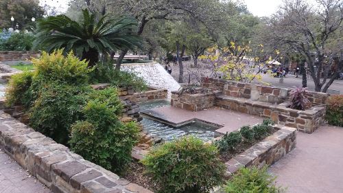
There are two water features in HemisFair park as well.  We found the first one a few years ago after the Asian New Year Festival when we took a shortcut through HemisFair Park back to our bus stop. The other we just discovered on Christmas Day of 2015.  Alex and I went downtown to see the Christmas lights and got there several hours too early.  So, we walked down to the Institute of Texan Cultures and then up through HemisFair Park.  We took a right turn when we normally make a left and discovered a beautiful fountain with water cascading down a sort of ziggurat-ish structure. We hung around there for a while, taking the path to the top and just enjoying the water.

HemisFair fountain
The top of one of the water features at HemisFair Park, Christmas Day, 2015

The Mexico Pavilion from the fair is one of the only buildings that I can find in the park that’s still open to the public.  This building is now the Mexican Cultural Institute (and it is the only national pavilion, aside from the United States Pavilion, that is still in the park).  Kitty-corner behind the Mexican Cultural Institute is the San Antonio branch of the Universidad Nacional Autónoma de México (“UNAM”).  The San Antonio campus of UNAM is primarily a language school.  I considered taking Spanish classes there at one time, but never have had the free time to do so. And if I were to do forward in my Spanish education, I would probably want to get a degree, probably a master’s degree.

There are three buildings left over from the fair which are not part of the park.  Two stand on the southern edge of the park, along César E. Chávez Boulevard.  One of these two is the John H. Wood Jr. Federal Courthouse, which originally was the Confluence Theater of the United States pavilion of the fair.  The other is now the Institute of Texan Cultures (“ITC”), which originally was the State of Texas Pavilion. The third building is the Henry B. González Convention Center.  Both the courthouse and the convention center have fallen into disrepair, which leads me to what is likely to be my final point with regard to the park.

Much of this information is soon to be out-of-date.  The city is currently overhauling the park.  There is a new convention center which, I think, is now complete. Soon the will raze the old convention center.  The city also has $135 million earmarked for a new courthouse. They will overhaul most of the park, as well. The plan is to put an apartment building in the park and there will be some retail businesses added.  I read something just today about the city wanting to put restaurants and other businesses in the empty houses in the park, and part of the population of the city is agitating to remove the ITC building and move the museum to a new location more central in the park.  The University of Texas at San Antonio, which owns the ITC, is resisting any such changes.

The ITC is surrounded by a metal fence.  I would like to see that fence done away with.  One of the big arguments of those who want to see the museum razed is that it doesn’t feel like part of the park.  Removing that damned fence would go a long way towards making the museum feel like part of the park (the other would be removing the parking lot, but in a car-centric city like San Antonio, I don’t think that will happen). I believe that the ITC is one of only three museums that I’ve been to that have fences around them. One other is the McNay Art Museum, which used to be a private home in a not-very-pedestrian-friendly area, and the other is the Vatican Museums in Italy, and it would be weird to take down the centuries-old wall there to make the museums more accessible.  I’ve been to a lot of museums mostly, but not necessarily all, in Chicago, New York City, San Antonio, and the District of Columbia. I’ve even been to the Reading Museum (because I wasn’t about to miss a chance to see England’s copy of the Bayeux Tapestry).  And people can just walk up to just about all of the ones I can think of.  Maybe I should have left this to my post on the ITC, which is scheduled for April 15, more or less, but I’m on a roll now, so I’ll just leave it.

This will probably end up being a Part 1.  Part 2 will follow in another two years or so, once they have the official opening of the renovated park.

National Geographic September 2013, Part 1

Rising Seas, by Tim Folger, photographs by George Steinmetz

Oh, look. Another article about climate change.  What a surprise.

This time we’re focusing on New York City and what can be done to protect it from both rising sea levels and from future storms like Sandy.  One possibility is to build storm barriers and another is to build a chain of barrier islands.  Apparently there used to be barrier islands in New York Harbor, but they were removed “by . . . landfill projects,” which I assume means that the islands are now part of either Manhattan or one of the other boroughs.

Folger suggests that New York City look to the Netherlands for ideas. The Eastern Scheldt barrier which protects Zeeland, is built to a much higher standard than is usual in the United States.  The dike system in Holland is not walls, as we picture, but are sometimes built almost invisibly into the landscape (Folger visits one that just looks to the casual observer to be an ordinary hill).  Rotterdam is also working on building floating buildings and are planning on having floating residences actually in the harbor.

We return to the United States and talk about some of the other places that could benefit from these kinds of remediations, including New Orleans and Miami.  Miami is a special case, however, because it sits on a limestone base, which means that you can’t block out the sea water — the water will just come up from underneath.  This might be a job for those floating buildings that they are working on in Rotterdam.

Big Bird, by Olivia Judson, photographs by Christian Ziegler

I always loved dinosaurs.  When we visited the Field Museum, I always had to visit the dinosaur hall.  My now-ex also always loved dinosaurs.  Early on in our relationship, we talked about how we’d always wanted to take the time to count the bones in the apatosaurus’s tail (though we still called it a brontosaurus at the time) but that the adults we were with always would get bored before we finished and drag us away.  So, of course, early in our relationship, we went to the Field Museum and counted the bones in the tail.  It was nearly 30 years ago, so I can’t remember the exact number we got, but 82 sounds familiar.  82?  182?  I can’t remember anymore.

With two dinosaur-loving parents, it was no surprise that Alex turned out to be fond of the big critters as well.  A wonderful thing had happened in the time between my childhood and Alex’s — they discovered that birds are theropod dinosaurs.  I never had to tell Alex that dinosaurs were gone — they were all around us.  It was magic.

The San Antonio Zoo is kind of bird-intensive.  The zoo has something like 750 species, 170-some of which are birds. When I bring someone new to the zoo, I always tell them that I need to show them our dinosaurs. They usually expect me to take them to the Komodo dragons.  Instead, I take them to the cassowaries — the birds have big three-toed dinosauresque feet and a casque on the head that always makes me think of parasaurolophus (the duck-billed dinosaur that has a crest on its head).

Cassowary, san antonio zoo
A cassowary at the San Antonio Zoo, 2014

This is a roundabout way of saying that I love cassowaries and loved this article.  Judson takes us to the Daintree Rainforest in Australia in search of cassowaries.  We “meet” Dad, who has four chicks (cassowary fathers take care of the young) and learn about the importance of cassowaries in the ecosystem.  Cassowaries eat fruit and the seeds pass basically undigested through their digestive tract.  This spreads plants around and increases diversity in the rainforest.  One tree, Ryparosa kurrangii, basically only germinates when it’s been pooped out by a cassowary.  Scientists are unclear on why being partially digested has such a beneficial effect on the seeds.

We also learn some of how humans are threatening the future of the cassowary.  As humans encroach on their territory, there is less space for the cassowary.  Some are killed by dogs or in traps.  And some die by being struck by vehicles.  There are several schools of thought about how to help the cassowary in the future, but no consensus has been reached yet.

My Travel Memories: Montreal, Quebec, Canada

All of this remembering our 1981 Canada trip has me thinking about taking a similar trip in the future.  We could, in theory, at least, fly into Toronto, then take the train to Montreal and Quebec City.  We could rent a car and explore some of the areas to the east of Quebec City or, if I don’t want to rent a car (I suspect I’ll have had enough of that after our Salt Lake City/Yellowstone/Dinosaur National Monument trip to last me a while), we might be able to take a side trip to either Halifax or Ottawa (but not both).

As I recall, we spent most of our time in Montreal in the Old City area.  We stayed at a hotel in the suburbs and took the Metro into the city.  It saved us a bundle, but wasted quite a bit of time.  I think Montreal was where we went in search of beignets, but since this was in the days before everyone had access to the Internet, we never did find any.

I also bought a French-language Wonder Woman comic book compilation while I was in Montreal.  I planned to learn French someday and figured that the comic book would give me some incentive.  Since then, I have made two attempts at learning French and was interrupted by tragedy both times (I think it was cancer the first time and my divorce the second).  So I gave up.  I will still learn it someday, but not until I’ve become close to proficient in all of the other languages, and I do mean all of them — Hindi, Arabic, Japanese, Russian, Lithuanian, Igbo, Korean, Vietnamese . . . .

While looking for pictures of the frescoes and wood in Notre Dame referenced in Dan Brown’s The DaVinci Code, I found some surprisingly lovely pictures of Notre Dame that showed it full of color and gorgeous carved wood.  Score one for Brown, I guess.  This surprised the heck out of me.  Then I noticed the caption — Basilique Notre-Dame de Montréal. So if you want to visit the version of Notre Dame that exists in Brown’s imagination, you’ll have to go to Montreal to do so.

Since we didn’t do anything in Toronto, I guess that next we’re on to our 1982 trip to Florida.  If I recall correctly, it was more days of hanging around the house (I seem to recall doing a lot of reading and we saw Poltergeist).  We also went to EPCOT during that trip, so that’s probably what I will focus on next.

I wish I could find pictures of our 1981 and 1982 trips.  I also wish I could remember where, if anywhere, we went in 1983 through 1986.

National Geographic April 1889, Part 1

Well, we’re back to the 19th century now.  There were only three issues in 1889, so this should go pretty quickly, provided I get enough hiking alone time to knock out the LibriVox versions of the issues.

Africa, Its Past and Future, by Gardiner G. Hubbard

Africa, Its Past and Future was surprisingly less racist than I was expecting. Now, I was expecting racism of both the “native Africans are lazy and useless” and of the “white people need to save them” types.

We start out strong, with an acknowledgement that Africa was civilized centuries before Europe was, then take a sharp downhill slide with the line “For ages upon ages, Africa has refused to reveal its secrets to civilized man.” Really? Ugh.

Let’s not even begin on Hubbard’s explanation that the Negro can find the “Mohammedan” afterlife more comprehensible than the (apparently superior) Christian afterlife. I can’t even.

Quite a large number of words are wasted in descriptions of where geographical features such as rivers, lakes, and mountains, are in relation to one another.  I spent quite a lot of this time wishing they’d just put a map in the issue.  And there is a map, but only of which areas of Africa are colonies of which European nations.  Nowhere, apparently, is there a just plain, you know, map.

Hubbard also talks about the colonization of Africa by Europeans, about how exploration of Africa (again, by Europeans) progresses, about the slave trade, about mining and mineral wealth, and about the titular future of Africa.

As to the future, as promised in the title, this article ends in a big question mark.  Apparently they can’t deliver what they promised.

Report — Geography of the Land, by Herbert G. Ogden

This was so gripping that I’m not a bit surprised that National Geographic has become a byword for engrossing education on the world around us.

That was a lie.  This was so. Boring.

Parts that were sort of memorable were the “barbarous tendencies” of the Africans, the “semi-civilized races” of Asia, and Ogden’s breathless anticipation of the surveys of New Jersey and Massachusetts.

National Geographic became more of a general interest publication in 1915, if I recall correctly.  That means I only have another 16 years of this to go before it gets interesting.  If I get that far.

Now, back to 2013.

I’m Supposed to Be Doing a Northern Illinois Destination Next . . .

But I think I’m going to take a five-month hiatus on that topic.  It seems weird to be talking about Chicago destinations right now (particularly since almost all of my photographs of Chicago have disappeared down the rabbit hole) when I just booked a trip to Chicago for August.  I haven’t been home in six years, so this will be nice.

Chicago Harbor Light 2010
Chicago Harbor Light, 2010. Taken with my old Palm Treo phone, if I recall correctly.

At the moment this is the tentative schedule:

Monday: Fly into Chicago.  Grant Park, Art Institute of Chicago, pizza.

Tuesday: Museum Campus during the day and Navy Pier in the evening.

Wednesday: Chicago Botanic Garden (Navy Pier if we fail to make it on Tuesday).

Thursday: Lincoln Park Zoo, Lincoln Park, fly home.

At some point, I want to visit some of my favorite architectural sights, including (but not limited to) the Chicago Cultural Center and The Store Formerly Known as Marshall Field’s.

National Geographic November 2015, Part 3

Against the Tide, by Kennedy Warne, photographs by Kadir van Lohuizen

We leave Greenland, heading towards a much smaller island, well, technically an archipelago made of much smaller islands. The first thing I learned from this article is the correct pronunciation of “Kiribati.”  Apparently the “ti” has more of an “s” sound than a “tee” sound.  This is one of the side effects of getting as much information as I do from written sources — you don’t necessarily know how to pronounce what you are reading.  I actually pronounced “Obama” to rhyme with “Alabama” the first time I said it aloud.

Kiribati is threatened by rising water levels.  The islands are actually coral atolls, and so they aren’t far enough above sea level to resist for long.  According to this article, the capital “will be uninhabitable within a generation.” How long is a generation? 25 years?  30 years?  50 years?  The article doesn’t say, but it’s probably not enough time.

The article is mostly an overview of what the I-Kiribati, what the people of Kiribati call themselves, are doing to help survive the foreseeable future.  They are learning to plant new crops, adding mangroves to the shoreline to help hold the islands together, and beginning to harvest rainwater from their roofs.  Hopefully we’ll find some way to help slow the warming of the earth before it becomes too late for the I-Kiribati and the other people of low-lying islands.

Who Will Thrive? by Jennifer S. Holland, photographs by Joel Sartore

Most of this issue surrounded the questions of how humans will adapt to the changes that the future will bring to the Earth.  This article looks into how the non-human animals that we share the planet with will fare. We don’t know yet which will do well, but it looks like, in general, the faster a species reproduces, the better it will probably do.  The more specialized its environment needs to be the worse it will do.

Pulse of the Planet by Peter Miller

In Pulse of the Planet, Miller looks at the kinds of imaging and sensors that we have available to us these days.  Some have been in use for a while, and some are brand new.

My Travel Memories, Quebec City, Quebec, Canada

This is one of those days that make me wish I had pictures of this trip available to me more than most. This is because Quebec City is one of the most beautiful cities I have ever visited. I don’t remember seeing much in the way of sightseeing, but my family and I spent all day just walking around.  I do remember spending a few hours on the
Île d’Orléans, though I think we just drove Route 368 around the perimeter of the island.

The city is what made the real impression on me (I’m a city girl, after all). We wandered the streets of the Old City, which is like visiting a 17th century European city. There weren’t even any cars there, that I can recall. We also walked the walls of the citadel. We walked at least ten miles that day and I would have been willing to spend more time there, but we were scheduled to go to Montreal and had to leave.

I always intended to return. In fact, I kind of dreamed of having my honeymoon there.  Instead of Quebec City, my now-ex and I ended up going to Indianapolis (more on that trip once we get to 1991).  We got married in November, so going north was not a good idea, plus he had only been out of college for three months at that point, so he hadn’t earned any vacation time yet.  He took two days off without pay, so we had to stay fairly close to home. I may get married again someday, if I ever get to a point where I want to date again (we’re coming up on the sixth anniversary of our divorce and I haven’t felt that desire yet) and, once I do, if I ever find someone I love well enough to marry again and maybe we’ll go to Quebec City for our honeymoon.  I’ve heard of people “dating themselves” (in the sense of going out and doing fun things alone and not in the sense of revealing how old they are) so maybe, someday, I’ll take myself on a honeymoon.

National Geographic November 2015, Part 2

And back we go into the climate change special issue.

How to Live With It

This isn’t really an article as such.  It’s just a collection of infographics or whatever on how water temperature, crop yields, surface temperature, weather, and our health are projected to change over the next decades.

Melting Away, by Tim Folger, photographs by Ciril Jazbec

Melting Away is about the changing cultures of the indigenous people of Greenland. Pretty much all of the agriculture in Greenland takes place in the south, so the thousands of people who live along the coasts stretching northwards still rely on hunting for their livelihoods.  As the ice shrinks, the migration patterns of their food animals is changing and making it more difficult to maintain their lifestyle.

Younger people are moving to the cities (for reference, Nuuk, the largest city in Greenland, has about half the population of the suburb that I grew up in), which means that the older way of life in the more central and northern areas of Greenland may be dying out.

As an aside, Greenland’s flag is awesome.  It may be my favorite flag ever. It’s simple and yet the off-center circle adds interest.

Greenland Flag
The flag of Greenland. Public Domain image created by Jeffrey Connell.

Two more articles to go, which I will probably post on or around March 20, and then on to September 2013.

South Texas Travel History, HemisFair 1968, San Antonio, Texas

This post is to give you some background on my next couple of downtown San Antonio destinations.  All of these, the Institute of Texan Cultures, the Tower of the Americas, and HemisFair Park, are left over from the 1968 World’s Fair, which had the title “HemisFair ’68.”  Under a principle known as “eminent domain,” the city seized the houses in and razed a residential neighborhood on the southwest side of downtown for the fair, which was a shame.  Over a hundred buildings in the neighborhood were named as historic by the San Antonio Conservation Society, but ultimately only around 20 were saved.  Those 20 houses are in the park today.

The theme of HemisFair ’68 was “The Confluence of Civilizations in the Americas,” and San Antonio chose to host the fair that year to honor the 250th anniversary of the founding of San Antonio. If a centennial is 100 years, a sesquicentennial is 150 years, a bicentennial is 200 years, is there a term for 250 years?  Let’s check Google.  Apparently 1968 was chosen in honor of the sestercentennial of the founding of San Antonio.  Or possibly the quarter-millenial, since 250 is one-fourth of 1,000.

Looking at the buildings that still stand today, it seems that HemisFair ’68 must have had an odd layout.  If you walk around HemisFair Park today, you’ll see that some of the buildings seem (to my mind) to point off in odd directions.  The park tends mostly west-to-east, or northwest to southeast, (starting at Alamo Street) but two of the pavilions, the Women’s Pavilion and the Eastman Kodak Pavilion, are off near the southern edge, with what sure looks to me like the entrances pointing southeast, away from the center of the fair.  The Universidad Nacional Autónoma de México  (“UNAM”) is tucked up in a strange place alongside the Henry B. González Convention Center with a door that faces, again, away from the center of the fairgrounds. The building that UNAM is in might not be original to the fairgrounds, though.  There’s something labeled “Amusement Area” in that spot on the map But it still seems kind of out of the way in its current location.  I wish I could find some kind of diagram of the flow of traffic or something that would indicate why these locations seemed to make some kind of sense.

Speaking of things that didn’t make much sense, there’s Beethoven Hall.  Today Beethoven Hall is home to the Magik Theatre, but originally it was the concert hall for the Beethoven Männerchor (Men’s Chorus). The planners for the fair decided that Alamo Street needed to be widened for the fair, and for some reason they decided that the best way to do this was to lop the front off of the building, then they just bricked up the hole in a way that looks very 1960s.   They could have widened the other side of the street, but the resulting street would have been curved, which the planners apparently felt would not give a good impression of the city to visitors (and north of Beethoven Hall the street curves anyhow, so I don’t know why they objected to having a curved street south of the hall).

Some of the hotels that were built for the fair are still there today. Of particular note is the Hilton Palacio del Rio hotel, which, for years, held a record for construction of 202 days. The rooms were built off-site and then lifted into place with a crane.  One of the hotels which is no longer there was the first La Quinta Inn.  If I recall, the original La Quinta is now underneath River Center Mall.

Ultimately, the fair did make a good impression on visitors, which cemented San Antonio’s reputation as a tourist destination.

National Geographic, November 2015, Part 1

So, no sooner did I start getting my act back together on posting than my hard drive went out.  So here I sit with my brand-new hard drive, which has a one-year warranty, so I should be set for a while. While I was gone, I read one (November 2015) and two halves (April 1889 and September 2013) of National Geographic issues, so now I just have to recap the one that I’m done with and finish the other two issues and recap them and I’m in business.

We set up a new password for our National Geographic account, so I can continue reading the issues online, rather than having to balance a magazine on my lap while I type.  That’ll help me get this done a lot faster. Now on to November 2015, which is the Climate Change issue.

The Will to Change, by Robert Kunzig, photographs by Luca Locatelli

The Will to Change is about what Germans refer to as the energiewende (should that be capitalized or not?  It’s a noun, and German nouns are capitalized, but I’m writing in English.  Kunzig and his editor opted not to capitalize it, but that seems wrong to me).  After the Fukushima power plant disaster, Germany increased its commitment to renewable energy. Angela Merkel promised to close all of Germany’s nuclear reactors by 2022 and she seems on track to do just that.  Germans are picking up the slack left by the nuclear power plants with wind farms and what what is known in the United States, at least, as net energy metering.  “Net energy metering” is when entities other than the power company generate their own power and sell any excess to the power company.  Generally, credits are issued and used to pay back the power company for any power drawn from the grid.  I’ve heard of some ambitious individuals who end up owing nothing to the power company and it is even theoretically possible to make a little profit at it.

There is a downside to the energiewende (still sticking with Kunzig’s choice here), however.  Since Germany is shutting down their power plants, the needed energy that is not generated by energiewende projects have to come from somewhere. And that “somewhere” is coal-fired plants.  The energiewende is driving down the cost of power, so they have priced themselves out of hard coal entirely and are left with lignite coal, the cheapest fossil fuel there is.  Lignite coal is dirtier than hard coal, meaning that it produces more carbon dioxide than hard coal.

Hopefully, over time the energiewende will reach a point where the lignite coal can be phased out, but even if it can never be completely weaned from coal, Germany is definitely on its way to a cleaner future.

A Blueprint for a Carbon-Free America, by Craig Welch, graphics by Jason Treat

I’m not overly fond of the term “carbon-free.”  Recently, Domino launched “carbon free” sugar, which is, um, well, water, since table sugar is C12H22o11.  Take out those 12 carbon atoms and what you have left are twice as many hydrogen atoms as oxygen atoms, which is water.  A carbon-free America would be one with no life left in it, since all Earth-based life forms are more or less made from carbon. A lot of dirt is carbon, as well. We’d have some metal left — iron (but not steel, since steel is iron and carbon), calcium (which is what is left over when you take the carbon out of limestone), a lot of sand and other silicon-based things like quartz (but no diamonds because, well, carbon).

I know that’s not what “carbon-free” really means.  “Carbon-free” is a shorthand way of expressing the idea of ending carbon dioxide emissions from coal, natural gas, and oil.  It’s imprecise, though, and that irks me.

This is just a short little blurb about replacing things that have carbon dioxide emissions with hydroelectric, solar and wind power.  The graphs are nice and show, among other things, how much wind could be generated by both onshore and offshore wind farms.

Power to the People, by Michael Edison Hayden, photographs by Rubén Salgado Escudero

Throughout the developing world (India, Uganda, and Myanmar are the examples given here), people are enjoying new freedom through the use of portable solar lights.  At the moment, one of the biggest players in the field is a company called Simpa, which charges around $0.35 per day to rent the light.  That can be a lot of money for someone who makes only a few dollars a day, but it also, for example, allows shopkeepers to stay open later to get more customers and, thus, more money.  And the solar lights are more convenient for the people using them than the old battery-operated lights some had before.  When the battery ran down they would have to travel to get a new battery. With the solar lights, when the battery runs down, they just put it in the sun for a few hours, which saves time and wear and tear on their shoes and joints.