National Geographic March 2016, Part 1

I don’t know when I’m going to get the reading done for this post, but I’m going to get started writing it up anyhow.  Hopefully I’ll get the reading done on June 28 or 29 and get this knocked out by the end of the month. I may also get a start on the July 13 post, which will probably be another San Antonio city park, between now and then, as well.

The day after this goes live, by the way, Alex and I are leaving for our Salt Lake City/Yellowstone trip. Assuming that the flight is uneventful, we’ll be landing pretty early in the day, getting our luggage and our rental car, and heading off to Pando, the most massive single organism in the world.

July 6 – I was sort of close.  I got part of the reading done in very early July but then stalled.  I intended to finish up the second article while waiting for a doctor for some jaw pain I’ve been having lately. I got right in to see the doctor and got right back out again.  It’s now July 6 and I’m just now starting on the writing.

Waste Not, Want Not, by Elizabeth Royte, photographs by Brian Finke

First, the meaning of the term “want” had moved from “the lack of” to “a desire for” by such an extent by my own childhood, that it took me a very long time to figure out that “waste not, want not” didn’t mean “if you don’t waste it, you won’t want it.”

Second, this article returns us to the Future of Food series for the first time since I’m-not-sure-when. It’s been so long that the “future of food” tag doesn’t even show up on my widget.

Now, onward.

A shocking amount of food is wasted in the world. Some of it is food that was purchased in grocery stores or restaurants and went uneaten, but a lot of it is actually disposed of at the site where it is grown. Sometimes it comes out malformed and the buyers, either the shoppers themselves or the buyers who work for the retail industry. Sometimes there is actually something wrong with the produce, such as a fungal infection or an infestation by parasites.

We follow Tristram Stuart as he puts together meals from discarded food. We see him buying crookneck squash that took their name just a little too seriously, for example. These squash become part of a squash tempura, turnip dumpling, and zucchini noodle meal.

In this article, we go on to France, Kenya, Peru, and back to the United States (Las Vegas, this time) to see what Stuart, and others, are doing to use unsalable food.

The Cold Rush, by Joel K. Bourne, Jr., photographs by Evgenia Arbugaeva

With the increasing warming of the Arctic region, several countries, including Canada, Norway, and Russia are attempting to harvest the natural resources that are coming closer to (and sometimes actually reaching) the surface. Norway is drilling for oil in the Arctic Circle, and Canada is mining gold and iron. Additionally, some ships (including a cruise ship) are taking advantage of the melting ice to take the proverbial “Northwest Passage”  from Europe to Asia through northern Canada.

It’s not all rosy, though. The Arctic Circle is so remote that workers need to be brought in in groups, the workers then live in those groups for weeks or months, and then they get shipped home. Also, ecological damage is being done. There are no oil pipelines that far north, so the oil has to be dumped into tankers, which leads to the risk of an oil spill. And, of course, mining always leads to damage.

The Azolla Event, which is the proliferation of azolla fern that led our carbon-rich atmosphere to go into an ice age, locked up more carbon than just the carbon in the fern. Some carbon dioxide was dissolved in the water and once the water froze, the carbon that was dissolved in it was trapped. Cold Rush points out that the melting ice is releasing further carbon into the atmosphere.

My Travel Memories: The United Nations, New York City

Alex and my trip to New York City covered pretty much everything we did in New York City in 1988, with two exceptions.  1.  the United Nations, and 2. The American Museum of Natural History. We fit a lot of things that we didn’t do in 1988 into our 2015 trip, though, and you can see them all under my 2015 Vacation category.

So, today we’ll focus on the United Nations.

At least in the United States, we tend to glorify World War II. At least in Europe, the United States was clearly on the side of the good guys. The Nazis were killing their own citizens by the millions.  It’s really hard not to be on the side of the angels when your enemies are that bad.

During the war, the “Allies” as they are commonly known (the countries that were fighting against Germany, Italy, and Japan) decided that they needed to find a way to avoid wars like this in the future. They began in 1941 with the Atlantic Charter, an agreement between the United States and the United Kingdom, and then about four and a half months later, 26 countries signed the Declaration of the United Nations. By the end of the war, the United Nations included 50 countries who signed the Charter of the United Nations in 1945. Of course, eventually Germany (then the nations of East Germany and West Germany), Italy, and Japan did join the United Nations.

The stated goal of the United Nations was to avoid a conflict like World War II from ever happening again. As an attempt to avoid all wars, it has been a pretty spectacular failure. The United States, in particular, has taken up arms in Korea, Vietnam, Iraq, and Afghanistan, at the very least, in the years since 1945.  Other countries have had their own conflicts, as well.

Has it avoided World War III? Perhaps the situation hasn’t arisen that would have ended up being World War III, but I like to think that just maybe it has. Unless, of course, future historians decide that the conflict in the Middle East that began in 2001 and involves something like 40 different countries, has been World War III, which I don’t think is an impossible development.

My own interest in the United Nations started in the 1970s, when Diana Prince (civilian alter ego of Wonder Woman) worked there. When I ended up being pretty good with foreign languages (a trait I inherited from my maternal great-grandmother, who spoke five), I thought about majoring in a foreign language and becoming a translator and perhaps I would have been good enough to get work at the United Nations.  We’ll probably never know. As I told you in my previous post on our 1988 trip, I was beginning to date the man who is now my ex-husband at that point.  I opted not to major in a foreign language because I knew that I was already only going to be able to see him every few weeks. I didn’t want to have to live in a foreign country for a semester (or more!) and miss seeing him for 16 or 32 weeks.

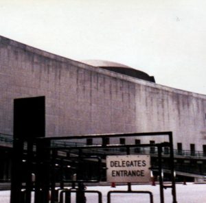
Delegates' Entrance to the United Nations, 1988
The old Delegates’ Entrance to the United Nations. This sign, at least, was gone when we were there in 2015. I think that the delegates now enter with everyone else.

When we visited the United Nations in 1988, we walked from our midtown hotel to the UN building. We walked down 45th street, so close to Grand Central Terminal that we could practically touch it.  Grand Central was on my list of places that I wanted to see in person, but we were on a schedule, so my folks and I kept walking. We made up for that in 2015.

The original hope for the United Nations was that they would find someplace unclaimed by any nation to hold their headquarters. That ended up being impracticable, so they decided on New York City as the location.  John D. Rockefeller bought an 18-acre parcel of land that used to hold a slaughterhouse and donated it to the United Nations. The United States ceded the land to the United Nations, so the headquarters is no longer part of the United States, though all of the laws that apply in New York City are enforced at the United Nations. The United Nations headquarters uses the US dollar as its currency, but it has its own stamps.

When we visited, none of the various organs of the United Nations were in session. This was bad because we didn’t get to see any of the activities of the United Nations, but it was also a good thing because our tour guide was able to talk about the General Assembly and the Security Council and things in the chambers themselves, which made it more interesting.

One of the most memorable parts of the tour, though, was the disarmament room.  This room has various artifacts in it, most notably coins and a statue that were in Hiroshima and Nagasaki during the nuclear blasts there. Our tour guide told us that the delegates had to walk through that room to get to the General Assembly chamber.  I don’t know if that was true then, and I am less certain of that now that the delegates apparently have to go through security with everyone else.

Alex and I are planning a return trip to New York City as part of our 2017 trip to Canada (which I’ve already saved up for).  The United Nations is going to be the top of our list of things to see if/when we do make that return trip.

National Geographic December 2015, Part 2

New New York, by Pete Hamill, photographs by George Steinmetz

Hamill, who was 80 years old at the time he wrote this article, grew up in New York City.  He explored it on foot and by subway through the decades, and in New New York, he looks back at the New York City of his youth and compares it to the New York City of today.  To some extent, Hamill seems to be having a “hey, you kids, get out of my yard” moment, to the extent that they have yards in New York City.  You know what I mean.

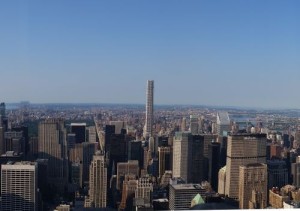
One of Hamill’s chief complaints is that the old neighborhoods are going away, being replaced by high-rise apartment buildings.  I have to admit that I share Hamill’s disdain for 432 Park Avenue, a big stick with windows a couple of blocks southwest of Central Park (see image).  However, part of the loss of neighborhoods can be placed on the emphasis on suburbs in the United States over the last seventy years.  Men who went off to fight in World War II came home and moved out of the cities into the suburbs, where instead of streetcars, they had automobiles and instead of neighborhoods, they had housing developments. Three generations (1946-1966, 1966-1986, and 1986-2006) have grown up living in separate boxes and traveling to jobs, schools, stores, churches, etc., in separate boxes.  The cohesiveness of a neighborhood is foreign to them.  And now, to get ahead in their jobs, they are moving into the cities and taking their isolation with them.

432 Park Avenue
432 Park Avenue, taken from the Empire State Building, July 2015. You can see Central Park off there in the distance.

Hopefully this isolation will only be temporary.  Once they discover the joys of being able to walk where they need to go, neighborhoods will form again.  Their children’s generation will be likely to connect, and reconnect, in both new and old ways.  Perhaps the old neighborhoods will never return, but it will be interesting to see what this new generation of city dwellers will create.

Haiti on Its Own Terms, by Alexandra Fuller, photographs by students of FotoKonbit

FotoKonbit is a project that allows Haitians to borrow cameras and photograph Haiti as they experience it.  Too many people outside Haiti merely hear of strife, poverty, and natural disasters.  FotoKonbit works with students both in the cities and in the rural areas to learn photographic skills and to show the outside world the beauty of Haiti as well.

The text accompanying these photographs goes into the history of Haiti and also a bit of its future.  You see, Haiti has billions of dollars of resources under its soil and someday people may come from outside to exploit them. This could be a benefit, if the companies extracting the wealth do it in a responsible manner and pay a fair price, or a disaster, if the companies follow business as usual and ruin the environment while cheating the Haitians out of what is fairly their own.

We’re Possibly Rearranging Our Upcoming Travel . . .

I’m currently in the process of rethinking our upcoming travel schedules.  Not for 2016; those are paid for and thus graven in stone at this point. Rather, I’m rethinking 2017 and following years.  Originally, we were planning to go to Europe in 2017, but then I discovered the SAIL Amsterdam event, which is an event where tall ships converge on Amsterdam every five years.  The next one will be in 2020.  I really wanted to take Alex for this, however, SAIL Amsterdam is held in late August, which would interfere with his school schedule (even though Alex will be in college by then).

When I was considering taking Alex to SAIL Amsterdam, I thought about taking Alex to Canada in 2017.  Then I discovered that SAIL Amsterdam was too late in the summer, so I was back to Europe in 2017. However, when I was researching other tall ships events, I found that there is a tall ships thing in Quebec City during what would be my normal window for our big vacation (from the Monday after the second Friday in July until the fourth Friday in July) in 2017.  This is perfect.  I had also hoped to return to New York City in July of 2017 anyhow, so we could fly out to New York, then take the train from there.  It would probably be easier to take the train from New York to Toronto then go in a circle, coming back to New York from Montreal, but we wouldn’t be able to spend much time in Toronto that way, not and make it to Quebec City in time.  Maybe Montreal, then right to Quebec City and then take our time coming back through Montreal to Toronto and back to New York?  That’s got some potential.

I’m not sure what will happen with Europe now.  2018?  We usually go to see a volcano in even-numbered years, and there are three volcanoes in Germany, so we could do that.  Or we could stick with our current plan to go to Seattle (Mount Rainier would be our volcano in that case) in 2018 and go to Europe in 2019.

If we do the New York to Canada and back to New York thing in 2017, both times I’ve flown out of Terminal 2 at JFK, I’ve had terrible vertigo, so don’t let me forget my Benadryl.

National Geographic September 2013, Part 1

Rising Seas, by Tim Folger, photographs by George Steinmetz

Oh, look. Another article about climate change.  What a surprise.

This time we’re focusing on New York City and what can be done to protect it from both rising sea levels and from future storms like Sandy.  One possibility is to build storm barriers and another is to build a chain of barrier islands.  Apparently there used to be barrier islands in New York Harbor, but they were removed “by . . . landfill projects,” which I assume means that the islands are now part of either Manhattan or one of the other boroughs.

Folger suggests that New York City look to the Netherlands for ideas. The Eastern Scheldt barrier which protects Zeeland, is built to a much higher standard than is usual in the United States.  The dike system in Holland is not walls, as we picture, but are sometimes built almost invisibly into the landscape (Folger visits one that just looks to the casual observer to be an ordinary hill).  Rotterdam is also working on building floating buildings and are planning on having floating residences actually in the harbor.

We return to the United States and talk about some of the other places that could benefit from these kinds of remediations, including New Orleans and Miami.  Miami is a special case, however, because it sits on a limestone base, which means that you can’t block out the sea water — the water will just come up from underneath.  This might be a job for those floating buildings that they are working on in Rotterdam.

Big Bird, by Olivia Judson, photographs by Christian Ziegler

I always loved dinosaurs.  When we visited the Field Museum, I always had to visit the dinosaur hall.  My now-ex also always loved dinosaurs.  Early on in our relationship, we talked about how we’d always wanted to take the time to count the bones in the apatosaurus’s tail (though we still called it a brontosaurus at the time) but that the adults we were with always would get bored before we finished and drag us away.  So, of course, early in our relationship, we went to the Field Museum and counted the bones in the tail.  It was nearly 30 years ago, so I can’t remember the exact number we got, but 82 sounds familiar.  82?  182?  I can’t remember anymore.

With two dinosaur-loving parents, it was no surprise that Alex turned out to be fond of the big critters as well.  A wonderful thing had happened in the time between my childhood and Alex’s — they discovered that birds are theropod dinosaurs.  I never had to tell Alex that dinosaurs were gone — they were all around us.  It was magic.

The San Antonio Zoo is kind of bird-intensive.  The zoo has something like 750 species, 170-some of which are birds. When I bring someone new to the zoo, I always tell them that I need to show them our dinosaurs. They usually expect me to take them to the Komodo dragons.  Instead, I take them to the cassowaries — the birds have big three-toed dinosauresque feet and a casque on the head that always makes me think of parasaurolophus (the duck-billed dinosaur that has a crest on its head).

Cassowary, san antonio zoo
A cassowary at the San Antonio Zoo, 2014

This is a roundabout way of saying that I love cassowaries and loved this article.  Judson takes us to the Daintree Rainforest in Australia in search of cassowaries.  We “meet” Dad, who has four chicks (cassowary fathers take care of the young) and learn about the importance of cassowaries in the ecosystem.  Cassowaries eat fruit and the seeds pass basically undigested through their digestive tract.  This spreads plants around and increases diversity in the rainforest.  One tree, Ryparosa kurrangii, basically only germinates when it’s been pooped out by a cassowary.  Scientists are unclear on why being partially digested has such a beneficial effect on the seeds.

We also learn some of how humans are threatening the future of the cassowary.  As humans encroach on their territory, there is less space for the cassowary.  Some are killed by dogs or in traps.  And some die by being struck by vehicles.  There are several schools of thought about how to help the cassowary in the future, but no consensus has been reached yet.

Christmas Present Ideas for the Travel Junkie in Your Life

No, this is not a hint.  I actually already have one of these and am seriously considering the other.  I am also not making a single penny from any sales that come from these links.  These are literally two of the neatest travel-related posters I have seen in 2015 and I want to tell people about them.

Though if either creator would offer me a commission, I don’t think that I’d be averse to accepting it.

Central Park Entire, the Definitive Poster Map is the one that I already have. It is, however, still in its tube. I unrolled it just long enough to admire its beauty and realize that I don’t have the foggiest idea where I will hang it. At 59 inches long, the poster is nearly as long as I am tall, and the ceilings in my house are not so high that I can keep my cats and dog from making it smell like them, if they choose to do so. I am considering having it professionally laminated, then if anyone rubs on it, I can wipe the oil off.

The poster is beautiful, with water features, structures, bridges, and every tree in the park marked on it (that’s over 19,000 trees).  If you need, for some reason, to know where the Turkish filbert tree is, this map will show you. There is also a folding version available for much less than the cost of the poster version.  I haven’t bitten yet on that version (though I may buy it before Alex and my next trip, which may be in 2017, depending on how finances go).

The second poster, Subway Systems at the Same Scale, is just what it says on the tin — the 140 largest subway systems in the world all on one map. These are not the transit maps — the ones that are not to scale and have all of the color-coding. These are pictures of where the actual train lines run, so straight lines are few and far between.  As a result, this poster is not as pretty as Central Park Entire, but it does look interesting.

Neil Freeman, the creator of Subway Systems at the Same Scale has more geographical posters, including Street Chains, which lays the streets of cities end-to-end alphabetically. It looks like these are only named, and not numbered, streets, because the far left edge of the Chicago one sure looks more like the half-block-long Abbot Avenue than all of the east/west expanse of 9th through 138th Streets.

2015 Vacation Destinations: Alex and Olivia Took the Subway in New York City, and You Won’t Believe What Happened Next

We didn’t end up in Brooklyn or something.

We didn’t get mugged.

We didn’t even get our pockets picked.

On the whole, taking the subway in New York City was a pretty pleasant experience. Now, Alex and I weren’t subway newbies or anything. Our first subway was the London Underground in 2002 (though Alex was too little to remember it) and then the subway in Toronto in 2003 (he doesn’t remember that one, either).  Alex does remember taking the Metro in Washington, DC and the subway in Rome in 2014, though.  But this was the New York City subway, which movies and television make look forbidding and dangerous. It may have been just the stations we went to, but we did end up going through (or, well, under) Jamaica and Queens (and we saw more of the bottom of Queens than we expected) and it was not terrifying, like I half-feared it would be. I could even see myself doing this on a regular basis, if I ever could get a job that would support me in New York City.

A Message from Malcolm, Central Park North subway station
Part of “Message from Malcolm” by Maren Hassinger, Central Park North subway station, New York City

I was often nervous when we got on a train, but that was mostly because of the existence of part-time train stations and express lines.  I was always afraid that we’d get on, say, a train that had a big B on the front at Cathedral Parkway (something that totally did happen) and it would turn out that this particular B train skips the Bryant Park station completely and we would have to get off at Herald Square or Washington Square and make our way back to our hotel from there somehow.  This, of course, never happened.  Nearly every time we got on the subway, we got off at the stop where we were supposed to get off.

The “nearly” was our last day in New York.  We were taking the subway back to JFK. While we were waiting on the platform for the E train, we heard “mumble mumble eee.”  It was an “e” sound, so it  could have been E, or B, or C, D, G, P, Z, or 3.  Soon enough, an E train comes along, and we get on.  After a few stops, though, the lighted map thing on the wall turns off and the train heads off the wrong direction.  Turns out all that mumbling was the announcement that the next E train was actually going to be an M train.  Fortunately, the E and M trains intersected another few stops down, so we got off the M train there, and caught the next E train, which stayed an E train this time, and we got back to the airport with something like three hours to spare. So that was our heart-stopping side trip into Queens.  So for next time, if I hear some kind of announcement that might have something to do with my train, I will ask.

Some New York City subway stations are wheelchair accessible. Many of the ones we used were not, but some, including the stations in Queens leading to and from JFK were.

2015 Vacation Destinations: The High Line, New York City

I have always loved trains.  My childhood home in the Chicago area was two blocks from a freight train line and many nights I was lulled to sleep by the sound of train horns.  I currently live not too far from a rail line and can occasionally hear the horns in the distance.  I also love to travel by train (more on that in my next, and likely final, 2015 Vacation Destinations post).

So when, in 2006 or so, I found out that an old section of freight train line on Manhattan was being repurposed as a public park, I knew that I would have to visit it.  And on our last day in New York City, Alex and I finally had a chance to go.

The High Line is on, as the name implies, an elevated section of railroad track.  Originally, the freight trains that ran on the line were on the street level.  After entirely too many accidents, the city decided to elevate the line.  Trains ran on those elevated tracks from 1934 until 1980 (the final train to travel the tracks consisted of an engine and three cars of frozen turkeys).  The tracks then sat unused for nearly 30 years.  Work began on the park in 2006, and the first section opened to the public in 2009.

The plants chosen for the High Line are largely the same types of plants that grew along the tracks during the years when the High Line lay abandoned.  There are lists of the plants used, but the list is kind of overwhelming.  For example, they used four different varieties of purple moor grass.  The Friends of the High Line website has a more easily digestible way to get to know the plant of the High Line through the “plant of the week” tag on their blog. I write these weeks ahead of time and schedule them for later, so the most recent plant of the week as I write this is goldenrod.  If you look at the website and go back to that post, be prepared for a picture of what you likely will immediately identify as ragweed.  Both plants flower at the same time, but they’re very different.  The big plumes of yellow flowers are goldenrod.  The ragweed that makes so many of us with hay fever miserable, is a much less exciting plant with little green flowers. In some places (see image below), the plants are placed alongside the original rails of the line.

rails
Purple coneflower and wild grasses along the rails of the High Line.

In addition to the plants, the High Line is home to a number of pieces of public art.  It is, of course, all modern art; so far no one has bought a Renaissance sculpture and donated it to the park, nor has it been there long enough for the works to become “classical.”  I admit that I don’t really “get” much in the way of modern art, but I actually liked this.  I think the setting made it somehow more accessible than I usually find modern art in a museum setting.  If that makes any sense.

The neighborhood around the High Line was interesting, as well.  We watched them constructing a new high-rise apartment building near the entrance where we climbed up to the park, and at one point, we walked past the High Line Hotel, which is in the building that once housed the General Theological Seminary (which, in turn, was built on land donated by Clement Moore, the author of “A Visit from St. Nicholas”).

The park passes over and goes through the art gallery district in Chelsea.  At one point, we needed to go back down to street level and we happened to pass the Heller Gallery,  which had an exhibition of Luke Jerram’s glass microbes.  I had seen photos of Jerram’s work, but had never seen any in person.  The man behind the counter was very gracious to two tired, sweaty tourists who just wanted to look around.  Jerram’s work was just as beautiful as I expected it to be, but it is more than a little nerve-wracking to stand that close to a piece of glass worth more than six months’ pay at my job.

The one thing that the High Line lacked was shade. The heat index was 100 (or slightly above) when we were there, and by the time we headed back down to the street level to take the subway to our hotel, I was longing for some kind of shade — a tree or some kind of shelter.  There are trees in the High Line, but since the park is so young, the trees are still little more than saplings.  Hopefully they did their planning correctly and someday those trees will be tall enough to provide shade to their visitors.  That time has not yet come, however.

The High Line is wheelchair accessible.  Six entrances, Gansevoort and Washington, 14th Street, 16th Street, 23rd Street, 30th Street, and 34th Street and 12th Avenue, have either an elevator or a ramp.  We were unable to find the 34th Street entrance to the park, but they were doing some sort of construction, so I suspect that the entrance may have been blocked off temporarily the day we were there.

2015 Vacation Destinations: Circle Line Tour (Best of NYC), New York City, New York

My folks and I took two tours when we visited New York City in 1988. One was the Gray Line bus tour, and the other was the Circle Tour.  Bus tours are all very nice, but I much prefer walking.  When I made the list of things I wanted to do on our 2015 trip, the Circle Tour was mandatory.

The Best of NYC tour, which circles the entire island of Manhattan, starts out at Pier 83.  The boat heads south along the Hudson River and then goes into New York Harbor, where it circles around Liberty and Ellis Islands.  The tour guide also pointed out the Central Railroad of New Jersey terminal, where many of the Ellis Island immigrants would catch their trains to other parts of the country.  My own great-grandmother was joining her husband in the Chicago area upon her arrival in the United States, so perhaps she and my grandfather took a train from that station after they arrived in the United States.

The tour goes along the southern edge of Manhattan, allowing the passengers to take photos of the skyline of Manhattan and then up the East River.  The tour guide pointed out the places where new construction was going up as we went around the island, including new condominiums in Queens and Brooklyn. In fact, the tour guide on this tour talked a lot about real estate.  He talked about the cost of condominiums on Manhattan and pointed out the unfortunately unattractive 432 Park Avenue, among other things.

The tour then goes west on the Harlem River, around Inwood Hill Park, and then back down the Hudson. Along the way, the tour goes under eight bridges and over three tunnels.  And, yes, you are aware of the tunnels.  The tour guide pointed out the air exchanges for the tunnels as we went by.

I thought the North River Wastewater Treatment Plant was particuarly interesting.  The building almost looks Roman, with arches along the length of the concrete building.  The top of the building is the 28-acre Riverbank State Park, with a swimming pool, a skating rink, a theater, and a restaurant.  There is also an “athletic complex” and an assortment of other types of sporting fields, including tennis and basketball courts, a softball field, a running track, paddleball courts, and a football field.  As you may have discovered (or may still discover) I love parks.  And I found the places that New Yorkers manage to put parkland, particularly this one, to be fascinating.

The Circle Line Tour boats are wheelchair accessible, though the restrooms are not.  There is both indoor and outdoor seating and the outdoor seating has both covered and uncovered areas.  I have a slight tendency towards motion sickness, particularly on boats, so the outdoor seating is a real plus for me.

To-Do List: Lighthouses

Unlike my last To-Do List post, which was something new that I’d just discovered and wanted to get started on, today’s To-Do List post is something that I’m actively working on already.

I grew up in Chicago, which does have a few lighthouses to its credit, and yet for most of my life, lighthouses were something that existed somewhere else.  We visited one (I’m pretty sure it was Jupiter Inlet light) during my childhood.  I definitely have visited that one during my adulthood.  We may have gone to Tybee Island light during one of our trips to Savannah, since we have a postcard of it.  I don’t remember it, though.

My interest in lighthouses goes back to 1993 or 1997, depending on how you count.  In 1993, when we first got cable, one of the channels we got was the Sci-Fi Channel, and I finally, after about 27 years of hearing about it, got to see the original 1966 Dark Shadows television program.  I became a fan instantly.  The town where Dark Shadows is set is described as being 50 miles from Bangor, in Hancock County, and on Frenchman’s Bay.  So once I had an Internet connection, in 1997, I set out to figure out where, exactly, that would be, and in the process, saw all kinds of photographs of lighthouses.  At first, I wanted to see one lighthouse, but then with time I decided that I want to see them all.

Since 1997, every time I visit a place that’s near water, I try to see at least one lighthouse (and if I can climb one, that’s even better).  In my 2015 vacation, I got three lighthouses in.  The first was the Statue of Liberty, which is no longer a lighthouse, but was one from 1886 until 1902.  My second and third were Blackwell Island Light and Jeffrey’s Hook Lighthouse (the subject of the children’s book “The Little Red Lighthouse and the Great Gray Bridge”) on our Circle Tour trip (more on the tour in a future post).

I still have never visited a lighthouse in Maine, though.