Every year, Alex and I visit some property of the National Park Service. In some years it’s a hardcore park like Yellowstone, others it’s a National Historic Site or something of that nature, like the National Mall or the Statue of Liberty. When we started planning the trip to California, I actually considered Channel Islands National Park for quite a while, but apparently they’re more fun for people who like to boat. And while I like to ride in boats, my only experiences with actually driving the boat involved me causing the canoe to capsize at Girl Scout camp.
So I went back to the proverbial drawing board and looked at the list of parks again. This time I did the math on Joshua Tree. I also asked a friend whose father is a retired park ranger and the friend said that Joshua Tree is a great place to learn about desert ecosystems. And with that I was sold. We ended up going to Joshua Tree.
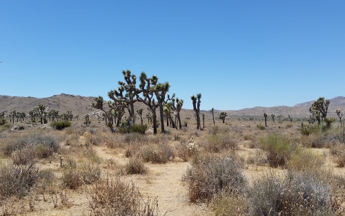
Joshua Trees at, well Joshua Tree
We intended to get up early and head out at about 6 or 7 am so that we could miss the hottest part of the day. Yeah. That didn’t work out so well. By the time we got there (quarter to noon) the only wildlife we saw was a coyote who was apparently running late.
We stuck to Park Boulevard for most of our visit, arriving at the West Entrance Station and leaving at the North Entrance Station. We took the Keys View detour to see if we could see the San Andreas Fault (which is visible on a clear day). Unfortunately, it was not a really clear day. It wasn’t cloudy, I don’t even know if it was smog. I’ve been toying with the image and I think I can see the fault. At least it looks like the thing that’s labeled the fault on other photos. It doesn’t look like any of the faults here in Bexar County, though, that’s for sure. We also considered hiking out to the Lost Horse Mine, but we didn’t want to commit that much time to the trip in the heat of summer. I think we did walk out a while, but didn’t get too far.
Overall, we spent three hours at the park and saw most of the northern half of the park. It looks like if you want to see most of the rest you’ll have to be a more intrepid hiker than I am.
I did bring the recommended amount of water (a gallon apiece) and I even used sunblock. I wear a face lotion with sunblock all of the time, but generally the rest of my body is left to its own devices. The informational signs were informative and the people we bumped into were friendly and maybe when I return to California someday I’ll take some of those paths that go out into the hinterlands. Not in the summer though. I promise.
Yay! It’s Gratuitous Amazon Link Time! And in what I’m sure is a complete surprise, I’m going to post a link to U2’s album The Joshua Tree in my article on Joshua Tree. An awesome album by an amazing band (and I hope they come to Texas again someday — I want to take Alex to see them).
I think I’ve updated y’all on the plans. At first we planned to go to Europe this year. We planned to fly into Amsterdam, then visit Rotterdam, then into Germany, where we would go to Berlin, Munich, and Heidelberg (stopping at Neuschwanstein just because). After that I had hoped to visit Brussels before going back to Amsterdam for the flight home. In my dream version of this trip, I hoped to stop off at Baarle-Hertog and Baarle-Nassau, the two towns of Belgium and the Netherlands, respectively, that are sort of intertwined with one another.
Late in 2016, we scaled that trip down to a trip to Canada. The plan was to fly into Toronto, then drive a rental car to Quebec City, where there is going to be a tall ship regatta this summer. But Alex made a friend in California and really wanted to visit there, so early this year, we scaled it further back to a week in Southern California.
I just realized this last week that one of our traditional July trip destinations is a national park. In 2011, we went to the National Mall; in 2012, it was Hawai’i Volcanoes National Park; in 2013, we had Great Smoky Mountains National Park, Fort Raleigh National Historic Site, the Wright Brothers National Memorial, *and* Cape Hatteras National Seashore; in 2014, it was Parco Nazionale del Vesuvio; in 2015, it was Statue of Liberty National Monument; and in 2016, it was Golden Spike National Historic Site and, of course Yellowstone.
But what to do in Southern California? I was hoping to get to Catalina Island while I am in California, since I’ve never been to Catalina before, but it’s expensive. Channel Islands National Park is less expensive so it was tempting, but apparently you have to pick one island, and the closest island is still an hour away by boat, and the boats leave from Ventura, which is an hour from our hotel. So that’s a four-hour round trip. And apparently there’s not really anything to do on the islands unless you like to kayak, which doesn’t seem like my sort of thing. There’s not even a place to take shelter from the rain on Anacapa, which is the one that’s only an hour-long trip.
If the boats traveled more like the ones at Statue of Liberty National Monument, where you could take one boat to Anacapa, then another in an hour or two to Santa Cruz, and so on, it might be worth it. Take a boat to one island and be stuck there for the rest of the day is less exciting for me (oh, and apparently the seagulls are nesting on the island in July, so it’s apparently noisy and smells like seagull poop). This means, of course, that if I want to go to an island, I’m back to considering Catalina.
In contrast, our hotel is about two hours away from Joshua Tree National Park. I’ve been looking at pictures and doing some reading, and you can see the San Andreas Fault from there, and there are a couple of oases in the park. So if I’m going to spend four hours in a rental car to get to and from a national park, Joshua Tree gets my vote.
Living with the Wild, by David Quammen, photographs by various photographers
In this final installment of Quammen’s article about Yellowstone, he talks about the Greater Yellowstone Ecosystem. He discusses where the term came from, the area it relates to, and how the park itself is impacted by things that happen in the “greater ecosystem” in general. You see, the Greater Yellowstone Ecosystem is not just the park itself, but the surrounding area.
One of the biggest problems is that, well, there are people in the Greater Yellowstone Ecosystem, and people have an impact everywhere they go. Most notably, once an animal leaves the park itself, it becomes potential prey for human hunters. And since the park is not fenced off, animals are entering and leaving the park all the time.
Additionally, some of the bison can carry brucellosis, a disease that can be transmitted to cattle and that causes cows to miscarry their calves. No cases of brucellosis being transmitted to cattle from Yellowstone bison have been found yet, but the potential is there, which causes conflicts between ranchers and the park.
The copy of the issue that I have (and likely the same layout that everyone got) suddenly stops in the middle of a sentence on page 137. We go on to some other material for four pages, and then we pick up where we left off on page 142. There is no “(continued on page 142)” or anything.
Quammen has no answers to the questions about what will happen to Yellowstone in the future. One of the people he speaks with, Dave Hallac, former chief of the Yellowstone Center for Resources, says that Yellowstone is facing a “creeping crisis”and doesn’t hold out much hope for the park. Is Hallac right? The scientists involved with Yellowstone are hoping they can forestall the crisis and save the park.
Other Material in this Part of the Issue
Voices: Bill Hoppe (Rancher, Wolf-Release Critic)
Voices: Leo Teton (Member of the Shoshone-Bannock Tribes Fort Hall Reservation, Idaho)
I know that the traditional image of dinosaurs is as being an interest that children outgrow, but I have to admit that I’ve never outgrown my interest in dinosaurs. So when I was looking at routes between Salt Lake City and Yellowstone and saw Dinosaur National Monument on there, I knew that we had to visit it.
In 1908 a group of paleontologists had found the femur of a Diplodocus near Vernal, Utah. Most of the bones had already been removed from that area, but farther on, they found a line of Apatosaurus tail bones. This area became the Carnegie Quarry. I cannot find any definitive answers regarding how many dinosaurs have been found there, but the tail bones they found were part of an entire Apatosaurus which is now on display in the Carnegie Museum in Pittsburgh.
Alex and I arrived relatively early that morning, driving through the rain from our hotel in Vernal to the Jensen entrance to the park. We nosed around in the Visitor’s Center for a while and then took the tram up to the Quarry Exhibit Hall, which encloses what is left of the original Carnegie Quarry. And there’s really not much left of the quarry. There’s a diagram showing that the current Quarry Exhibit Hall area is about a quarter of the size of the original wall. If you take it in three dimensions, it’s an even smaller proportion than that.
Alex and I spent quite some time looking at the bones in the wall. I took lots of pictures and asked two women working there what I should make sure to photograph. The one who answered me said that she liked an area that was mostly spines.
The wall of spines, Dinosaur National Monument, 2016
There is also a spot where visitors can touch one of the bones in the wall. Of course Alex and I had to touch it, because why pass up an opportunity like that?
About a thousand years ago, this area was also home to the Fremont, a Native American people. The Fremont left their mark on the region as well (though more intentionally than the dinosaurs did). Some of the rocks of the park have petroglyphs and pictographs. Petroglyphs are designs carved into the rock and pictographs are designs painted on to the rock.
We had to hit the road if we wanted to spend any more time in Salt Lake City, so we only went to the closest section of petroglyphs, in what is known as the “Swelter Shelter.” I had seen pictures of the drawings of humans out by McKee Springs, but the road out there is dangerous when it’s raining, so we opted not to go out that far. Maybe someday, though.
Sorry for the gap, but I’ve been stressed out lately and so dealing with that took precedence over blogging. I need to get more prewritten posts racked up before this happens again. Oh, well, this is a learning process, isn’t it?
Now, on to the issue.
Into the Backcountry, by David Quammen, photographs by various photographers
In this part of the issue, we talk about wolves, grizzlies, and elk. Quammen spends a while talking about changes to the environment and the introduction of lake trout to Yellowstone Lake. You’d think that lake trout would thrive in Yellowstone. And you’d be right. The problem is that the lake trout are thriving just a little too much. Grizzly bears eat cutthroat trout. The cutthroat trout eat bugs on the surface of the water and come into the rivers to spawn which make them available for the grizzlies to eat. At least that’s how it’s supposed to work.
The lake trout outcompete the cutthroat trout and are also basically unavailable to bears. The lake trout eat crustaceans from the bottom of the lake and also spawn down there, meaning that their nutrients are locked inside their bodies for too long to support the grizzly.
As a result, for the last five years, Yellowstone has hired a company from Door County Wisconsin which brings boats and nets and slaughters literally tons of lake trout every day. The dead lake trout are then dumped back into the lake so that their nutrients will be available to the ecosystem once again. Quammen doesn’t believe that this will end the reign of the lake trout, but the humans are trying the best they can to restore the balance to the ecosystem.
Other Sections in This Part of the Issue:
Voices: John Craighead, wildlife biologist
The Carnivore Comeback, a pictorial of predators
Tracking the Wildlife Highways, another pictorial, this time of migrations, including a section on the migration of pronghorn.
I’m a couple of posts behind here because this issue, which focuses on Yellowstone National Park, has an unusual structure. There are pictorials and things punctuating several pretty long articles, rather than larger and smaller articles. So I guess I’ll treat the photo essays and things as if they were articles as well.
America’s Wild Idea, by David Quammen
America’s Wild Idea is the first photo essay, which is accompanied by photos by several photographers. The text isn’t unified but complements the photos that are near it — a blurb about the prismatic springs near a photo of the springs themselves, a statement about interactions (and conflicts) between humans and grizzly bears near a photo of a man who was attacked by a bear, and so forth.
The Paradox of the Park
No writer is credited on this section. We start out talking about, once again, conflicts between grizzlies and humans, and then go into the history of the park. One of the points that the (to the best of my ability to determine) makes is that originally Yellowstone wasn’t supposed to be about establishing a truly wild place. It was more of a place designed to protect prey species from predators. To this end, nearly every carnivore in the park, from grizzly bears on down to otters and skunks, were hunted. Then they discovered that bears could be a draw. The problem with this was that the bears in the park were habituated to humans and would eat out of garbage receptacles.
We kind of end this article on a cliffhanger — “But the grizzlies of Yellowstone were never tame,” and that’s it. I think that perhaps this was intended to be kind of artistic, wrapping around to the conflicts at the beginning of the article, but I was left less than impressed. I think that maybe this was because the article ends in 1929, but begins in 2015. That’s a gap of nearly 100 years. I guess that the attack could prove that the grizzlies weren’t tame, but it could also well indicate that something changed in the interim.
Other Pictorials and Things
Back when I made my posts on Yellowstone, I said that I’d read something where the superintendent of the park, Dan Wenk, said that they need to limit the number of visitors to the park. I found it. It was on the next page after The Paradox of the Park. I still think that limiting cars would go a long way towards the goal that Wenk espouses.
The rest of this part of the issue are more pictorials, It All Starts with Heat, The Fire Within, and For the Benefit and Enjoyment of the People.
Next up: More Chicago pictures and then we go onto the next article, Into the Backcountry.
History’s Backyard, by Adam Goodheart, photographs by Michael Melford
First, I was kind of surprised to find that “backyard” spellchecks. Upon further research (and contemplation) I realized that I’ve generally seen noun as two words, but the adjective as one. So it should spellcheck, but it definitely looks like it should be “Back Yard” in this instance. I keep expecting it to be History’s Backyard Something (barbecue? garden?)
Anyway, the “backyard” in question is the Brandywine River in Delaware. The article goes into some of the historical events that took place along river. As this issue went to press, the government was contemplating including an area including the Brandywine River in the National Park Service. They did eventually do just that. Originally, it was made First State National Monument, then in 2015, it became First State National Historical Park, the first national park in Delaware.
When Push Comes to Shove, by Mel White, photographs by Paul Nicklen
When Push Comes to Shove is about conflict over manatees in Kings Bay, Florida. When this issue was written, over 600 manatees would spend the winter in the bay, and the manatees are a huge draw for tourists and drive quite a bit of the local economy. You see, the nearby town of Crystal River is the only place that allowed people to get into the water with the manatees.
The conflict is that the government, which has an interest in preserving biodiversity (which means preserving the manatees in particular) for future generations, wanted to enforce speed limits on boats in the area to protect the manatees. Ideally, they would have liked to make Kings Bay off-limits to swimming with the manatees entirely.
I have been unable to determine what, if anything, has changed about this situation in the last three years. I am thinking, though, that a happy medium would be to have licensed manatee tour operators. If visitors who are allowed to swim with the manatees are required to go through a tour operator, then the tour operator would be required to limit swimmers to those that they can supervise (and thus keep from harming the manatees) successfully. Manatee Visitor Supervisor could become a new growth job in the region.
Look it’s September 3 and we’re back. I probably shouldn’t be as surprised by that as I am, but it is nice when my schedule works out as planned.
We got out a little earlier on our second day in Yellowstone, but not as much earlier as I would have liked. We actually bought breakfast in the hotel for once, so that used up some time, and then we went to the supermarket in West Yellowstone, which was *not* like the supermarkets back home. The produce section was very small and most of the store was prepackaged food. We generally like to get our pop from a supermarket rather than convenience stores, because we can get six bottles for the price of two or three from a convenience store. I’m never going to be able to retire on those savings, but it helps. The supermarket we visited didn’t even have six-packs of pop, just the same individual bottles you get at the convenience store. So that used up some time.
Then we hit the traffic. It was a Saturday, so Yellowstone was more crowded than it had been on Friday, but the biggest problem was road construction. It’s winter for quite a long time every year at that elevation, so tourist season is also construction season. And while we were there they were fixing the Grand Loop Road leading to Old Faithful. We wanted to get to Lake Yellowstone anyhow, so I suggested that we go around the long way, past the lake, and back to Old Faithful. We realized that would be at least a two-hour drive, so we opted to try our luck with Grand Loop Road. I have basically no sense of time, so I don’t actually remember how long we sat there; it certainly seemed to be longer than the half hour they expected it to be.
I had also just recently read that National Geographic article on Denali where we find out that there is a big parking lot by the visitors’ center and that everyone who goes into the park takes a bus. Visitors can get off the bus pretty much anywhere and then get back on the bus pretty much anywhere as well. I sat there in traffic wondering aloud just what it would take to implement a similar program at Yellowstone.*
Finally we made it to Old Faithful and, in contrast to the previous night, we had trouble finding a parking place. Our rental car was white, as were a lot of the other cars in the lot, which made it more fun to find the car in the lot on our way out.
We got there so late that we wrapped around to being really early, so we ended up with time to kill. We bought some souvenirs and a couple of soft pretzels in the Old Faithful Lodge while we waited. Then when we went back outside the only benches available were way off to one side, so we sat on the boardwalk itself, which ended up being a nice place to sit, because it gave me a nice angle on the grasses in front of the geyser as they waved the breeze.
Old Faithful, 2016
A helicopter landed out behind the Old Faithful Inn while we waited for the eruption, and Alex loves vehicles of all types, so we went in search of the helicopter. It was a nice walk, and Myriad Creek, which runs behind the Inn, is very pretty, but we could have just followed the signs to the medical clinic, because that’s where we found the helicopter.
After that we went into the Visitor’s Center because I promised myself that I would go into the backcountry at least once, but I’m also not an idiot. I know that people can get hurt or killed if they exceed their hiking abilities. So I asked the park ranger there what he would recommend for a “baby” hiker. He recommended a fairly easy path that would take us two hours to complete. We ended up walking 45 minutes or so, out and back. We did head into the woods briefly just to do it, but I put hiking mode on my phone so that we wouldn’t get lost; we were able to just follow the path that we’d walked out back (take that, Hansel and Gretel!).
Back to Old Faithful, though. We considered having ice cream at the Old Faithful Inn before heading back out, but the lines were tremendously long and we figured that we could get ice cream at Lake Yellowstone (spoiler alert: we were never able to find it). So we headed out.
We stopped at Isa Lake, which sits right on the Continental Divide and is notable for being the only known natural lake that drains into both the Atlantic and Pacific Oceans. Then we made it to Lake Yellowstone, which is not the easiest place to find parking, believe me. The parking lot for the hotel was full, as was the parking lot in front of the hotel, and there was exactly one spot available in the parking lot for Lake Lodge. Since we didn’t find ice cream there, we chose to go somewhere we were certain would have ice cream — the Canyon Village Deli, where we’d had sandwiches the previous day. So we headed back up towards Canyon Village and got ice cream. I tried the huckleberry flavor, which was pretty good, but after all of that driving, I needed chocolate. So Alex and I both got cups of Moose Tracks and mint chocolate chip. And, as with the previous day, the people there were great.
We would have liked to have spent more time at Yellowstone, but I wanted to make an early night of it so that we could head out for Vernal Utah early the next morning. We didn’t make it out (of the park or of our hotel) as early as I would have liked. You see, on our way out, we finally had our first wildlife-induced traffic jam. We’d had gapers’ blocks from wildlife alongside the road (a black bear, a grizzly bear, a bull elk, etc.), but on our way out, we actually ended up behind a bison. Alex attempted to take a picture, but the bison was near the center line on the road so he couldn’t get it for me. As luck would have it, the car in front of us came to a complete stop at one point, giving me a chance to stop completely and put my car in park long enough to snap a quick picture.
It was nearly dark by the time we made it back to the hotel, so we went right to bed and, the next morning, headed for Vernal Utah. We’ll return for that drive on or around September 11.
*I did some research later and by my calculations, you would need a 2700-car parking garage just outside each entrance, which would be about half the size of the parking garage at the San Antonio International Airport. You could drop San Antonio into Yellowstone and still have space around the city, so if you can drive past the airport parking garage and not notice it (which you can), it should be possible to build those five garages without too much disruption. Alex objected, saying that most people would probably want their cars. So I figure that you let the most motivated drivers bring their cars. Let a couple of hundred cars in at each entrance (for an extra fee) every day. This would reduce the size of the garage that you would need to maybe 2500 cars. Of course, RVs that are headed towards the campgrounds would always be allowed in, so long as they go pretty much right to their camping spot.
I don’t know how long my discussion of Yellowstone will turn out to be, so I’ve tentatively labeled this as Part 1.
Alex and I got kind of a late start on our first day at Yellowstone. The drive from Salt Lake City had taken a lot longer than we had expected. In addition to the two hours of scheduled stops, and the unscheduled more than an hour Rocket Display stop, I forgot my rescue inhaler, so we had to transfer it to a Walmart in Idaho and wait for it to become ready. I estimate that rather than taking four or five hours, it took eight or nine. At this point, I was not in a rush to get back in the car, even though I thought that I’d get plenty of time out of the car at Yellowstone.
I didn’t get lots of time out of the car at Yellowstone. Let’s put it this way. San Antonio is the 67th largest city in the world in terms of land area. You could drop San Antonio on top of Yellowstone (not that I’d recommend this) and still have lots of space around the edges (19 miles all the way around, if my math is correct). So, yeah. Unless you book a bus tour, expect to spend lots of time in the car.
Overall, I have to give Yellowstone a solid four out of five stars for producing megafauna to gawk at. Minutes after entering the park, we saw our first bison. By the time we left Yellowstone heading for Dinosaur National Monument, we saw even more bison (including several herd of bison in the distance, one ahead of us blocking traffic, and one alongside the road so close to our car we could hear it breathing — that was unnerving), a black bear (which was too close to the road, but we stopped and took a couple of pictures anyway, a grizzly bear (likewise), at least one yellow-bellied marmot, and at least one elk (or maybe one elk and two moose cows, or possibly two elk and one moose cow). I think I saw some pronghorn antelope in the distance once. We also heard something howling on two separate occasions (I’m not sure if they were coyotes or wolves). No dall sheep or actual sightings of wolves, and also it would have been nice to have gotten a picture of the things that I thought might be pronghorn. If I’d gotten those squares on my megafauna bingo card, Yellowstone would have rated five out of five.
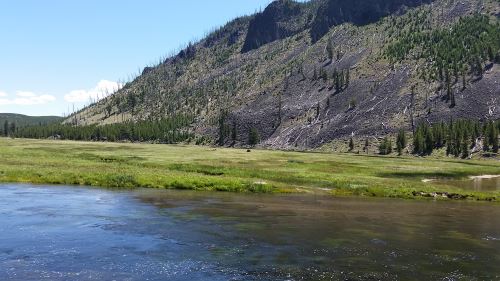
Believe it or not, that brown lump pretty much right in the center of the image is a bison. I also have some closer photos of it, but I wanted to share just the tiniest bit of the scale of the park as well. The water in the foreground is the Madison River.
We chose not to go to Old Faithful first because Alex wanted to do some stargazing and I read several things that said that the area around Old Faithful is a good place to stargaze, largely because there are people there pretty much around the clock. Since it was just the two of us, I figured that keeping to populated areas after dark would be a good plan. As it turned out, 81% of the moon’s disk was visible that night, so the light pollution from the moon ended up causing us difficulty with the stargazing. I still owe Alex a stargazing trip.
Back to that morning. We’d heard that there had been snow at the higher elevations in Yellowstone, so since we started out kind of hungry, we chose to eat at the Canyon Village, which is the highest in elevation (I hoped that perhaps Canyon Village would be close enough to the highest elevations that we could see if there actually was snow up there and maybe find a route up to it). We ended up eating sandwiches at the deli and while they were, you know, sandwiches, and not terribly exciting as cuisine goes, the people there were very pleasant and helpful. This set a very nice tone for the day.
After we ate, we stumbled across the Grand Canyon of the Yellowstone, which is a place where the Yellowstone River cut into the rock and, well, created a canyon (just like it says on the tin). We found, and spent entirely too much time photographing, the Lower Falls. We saw a boardwalk that led down towards the river and, because I’m too adventurous for my own good sometimes, I convinced Alex to go down there with me. The trip down was great, but the trip back up was a bit strenuous. Just a year ago, he and I had climbed the Statue of Liberty with no problem, so I was sort of distressed about just how difficult I found the walk back up. However, the elevation of the Grand Canyon of the Yellowstone is around 6,000 feet, so perhaps that made at least some of the difference.
After this, we went in search of even higher elevations, which led us up into the northwest corner of the park. I didn’t want to attempt to climb Mount Washburn. Oh, who am I kidding? I probably would have totally been up for it (despite the adventure I had coming back up at the Grand Canyon). Alex talked me out of it. Mount Washburn was probably our best shot at seeing snow on this trip, too. Oh, well, maybe it’ll snow in Dallas this year and we’ll luck out and be able to go up to Dallas to see it.
While we were in that corner, we drove into Fort Yellowstone, where we saw an animal that I at first identified as a horse. Alex was taking pictures of it, and I asked him why he was taking pictures of “that horse.” He told me that it clearly was not a horse and later, when I looked at the pictures, I think it might have been a moose, though it was more of a yellow color than I was expecting. Looking at other pictures of moose and elk, maybe it was an elk.
We parked and kind of knocked around a while at the Mammoth Hot Springs area (and I would like to go back and stay at the Mammoth Hot Springs Hotel some fall or winter) and took a lot of pictures of the thermal features there.
At this point, it was getting pretty late and we were looking at an hour and a half drive, so we headed towards Old Faithful. We took even longer than that, because we found a whole area of thermal features that needed to be explored and photographed.
Finally, with the sun beginning to sink in the west, we headed for Old Faithful. We got there just after an eruption, so we had an hour or so to kill, and during that time, the sun went down almost completely. I took some photographs of the geyser before the sun went down and then again afterwards (I also videoed the eruption, but my phone camera is not fantastic at night photography, so the video is mostly whooshing noises and blackness). We stuck our heads into the Old Faithful Inn (I had wanted to visit the Inn because I remember the 1988 wildfires that came *this* close to threatening the Inn). We then went to the Old Faithful Lodge and got a drink and two huge cookies to eat while we waited.
One of the nice things about watching Old Faithful erupt after nightfall is that almost no one is there. We had fantastic seats. And the geyser gave us a nice several-minute show. After the eruption we looked at the stars for a bit, but I wasn’t sure if they really would let us out of the park that late at night, and we still faced a 45-minute drive (during daylight hours — we were driving just a little more slowly because I didn’t want to end up wrapping the car around a moose or something) back to West Yellowstone, so we headed back out. We stopped along the way and looked at the stars again on the way, as well.
And, since we’re at over 1,000 words, this looks like a good place to stop for now. So I will end up with at least two posts on Yellowstone. We’ll meet here in Montana/Wyoming again on September 3, I think?
I have to admit that I keep forgetting what year it is. I work as a pharmacy technician and, as such, I have to keep an eye on expiration dates for the medications and if they expire in less than a year I have to change the expiration date on the label to match. Somehow, this ends up with me thinking that it’s a year ahead of when it really is. As a result, I may end up labeling some of these as being in 2017.
Anyway, back to the subject at hand. Alex has always loved vehicles. He now is into spacecraft and airplanes, but trains, cars, trucks, he’s really fond of them all. So when I was planning this trip and someone told me that the site where they drove in the golden spike that completed the transcontinental railroad was just north of Salt Lake City, I had to add it to our itinerary, even though it would slow us down by at least an hour. The original drive from Salt Lake City to Yellowstone was only about four and half hours, so what’s an additional hour between friends, right?
Well, first we made the stop at Great Salt Lake State Park, so that added another hour to the trip, so instead of the five and a half hours I was expecting, we ended up at six and a half hours. But I live in Texas, so spending six hours or so behind the wheel of a car in one day is nothing new. Although, admittedly, those six hours are usually a round trip and not just the outward trip.
So now we’re looking at a six and a half hour trip. But then as we’re heading out on route 83 on our way to Golden Spike, we pass a sign that says, “Rocket Display.” Alex wants to see it, and my first instinct is that it’s going to turn out to be some old man with random parts in a barn or something, but I agree to go, so long as it’s not too scary when we get there.
Turns out that “Rocket Display” is a rocket garden in front of the offices of Orbital ATK. Many of them were more missiles than rockets (and I tend toward the pacifist, so I was not terribly enthusiastic about that aspect of it), but Alex loved it and took at least one picture of everything in the garden. They did have the rocket booster from a space shuttle, which is really a challenge to photograph well, I’ll tell you.
After an hour (maybe longer), Alex and I were back on the road to Golden Spike National Historic Site. We got there around 3:00 p.m. and, if I’d been willing to hang around in the heat (or in the gift shop) for a full hour, we could have seen them put one of the replica engines in the shed.
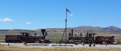
The replica engines at Golden Spike National Historic Site, 2016
I kind of wish I’d gone to Golden Spike when things were slightly less, you know, hot so that we could have seen the engines move back into their shed. Despite what I was told about the desert feeling less hot because it’s a “dry heat,” it still felt like we were standing under a heat lamp out there to me.
Most schoolkids learn the story about the transcontinental railroad in school in the United States. The Union Pacific Railroad started construction from the Mississippi River heading west and the Central Pacific Railroad started construction from Sacramento heading east. When they met at Promontory, the heads of the two railroads held a big ceremony when a literal golden spike was driven into the track and into a tie made from laurel wood. Immediately after the spike was driven, by the way, they pulled both the spike and the tie out and replaced them with an ordinary spike and tie. The original golden spike is on display at Stanford University.
There were a number of things that were on display at the site that were interesting. Apparently when they changed from iron to steel rails, they changed the shape of the rail. There is a piece of what they claimed was the original rail from that section of the track on display there, despite most of the track having been sent to be recycled for the war effort during World War II. There is also a monument to the Chinese workers who built the railroad. And there are a number of historic photographs. I love historic photographs.
Most of the site seemed like it ought to be accessible to wheelchair users. There is a part of the site that is on the other side of the tracks, and there is a kind of ramp over the tracks. The other side is unpaved, however, and aside from a few interpretive signs, the only thing on that side is two wooden staircases that take one up to look inside the replica engines. I don’t recall them having any kind of ramp, however, so that part is probably not accessible.