Long Day June 29, 2022

So today’s been kind of adventure from a phone perspective. Well, in general, really. 

First, I had a nightmare about Thomas and the end of our marriage and that was distressing. I mean come on now my 17 year marriage ended. That was by definition pretty stressful. And it has been on my mind a bit lately. That woke me up at 5:30 this morning, and I had trouble getting back to sleep. Mind you, I had to be up at seven to go to work. It took me a while to get back to sleep. I ended up getting up at 7:10, got myself together as fast as I safely could, and got to work 10 minutes early. Additionally, thanks to a clerical error that I didn’t catch until too late, I was actually scheduled for half an hour before the pharmacy opened. So I was there 40 minutes before the pharmacy opened. I got some steps in, so that was nice.

The day went okay, mostly, and, well, I have a Pokémon Go friend in Houston who always sends me raid invites during Raid Hour on Wednesday (from 6 PM till 7 PM in your local time). I always feel bad, because I’m in the suburbs and there’s not really anybody playing at that time. I mean, Walker Ranch Park usually has someone, but the parking lot is small and the overflow parking areas are now taken up by construction. So I almost never can send invites back.

So, after doing some research, I realized that I could be at the Pearl by 6:00 pretty handily, and there’s lots of parking there. So today I decided to go down to the Pearl after work. I could get some more steps in and hopefully get some Pikmin Bloom . . . I’m not sure what to call it. It seems that the game has new Pikmin spawn in places where you spend a lot of time. Like, there are always a bunch up by my work and a whole lot by my house. Since, as I said before, I live in a suburban area, that means I have a lot of Pikmin with stickers that say “S” for, near as I can figure, “Street.” So I’m always on the lookout for new locations. I figured that after I did my raid or raids, I could do some expeditions around the Pearl and maybe get some more expeditions out there in the future.

So after work, I headed off. I don’t like the Google maps navigation thing. The last time I used it, for example, it literally told me three times what street I should be on, then said, “turn right here” with no warning, so I ended up having to go around again, which was a waste of time and gas. So I just memorized the street names and the direction I needed to turn and headed out.

Okay, time for an interlude. When Thomas got his first cell phone it was on his work plan with Sprint. Once he left that job, they let him take the phone and number with him. His new job also gave him a phone, so I took over that original phone account. Basically, someone in Alex’s family has had this phone number for 25 years. Then after the divorce, I took over the account. Well, once T-Mobile bought Sprint, they said they’d shut down Sprint’s network and they sent out Sim cards. The deadline for the shutdown of the network was June 30, 2022. Which is tomorrow. Turns out, they shut it down right at midnight Greenwich time. I intentionally sat on the chip until the network went down because as fond as I am of my current phone, it’s starting to show its age (locking up, overheating, etc.). And in order to get a new Samsung phone at my store, I need to be fully on T-Mobile’s network. So I figured that once Sprint’s network shuts down, I should be fully on T-Mobile’s network and can get the Samsung phone I want.

I was not expecting it to go down just before I arrived at the Pearl. I was approaching McCullough, preparing to turn right, when my phone beeped. It was the notification that I no longer had service. So, rather than turning right and going to the Pearl, I had to make a left and head home. OMG.

So I headed home. Once I got connected to my Wifi, I discovered that I’d missed a raid invite. After doing another raid, courtesy of my friend, I installed the SIM card. I restarted the phone, which was apparently not restarty enough, so the phone restarted again and then it started to overheat. Eventually it settled down, and now when I boot the phone up, it has that nice violent pink color of T-Mobile instead of Sprint’s yellow. I am giving the thumbs up now, but you can’t see it.

I ate a little dinner and then decided that I wanted to do some more walking, partially for my health, partially for my Pikmin Bloom weekly event, and partially because it’s something I enjoy doing. Unfortunately, it was still way hot outside. So I went to take a one-hour nap, which ended up being a one-and-a-half-hour nap. Now I have to give my dad his eyedrop, eat a little something else, get rid of some more Easter candy (I still have a little more than one bag of jelly beans), maybe take a brief shower, since it’s really humid and I’m sweating like whoa, take my medicine (including my tretinoin for my acne scars), brush my teeth, and head to bed.

Now for a Gratuitous Amazon Link. Hm. Where was I? I think that The Witch’s Heart, by Genevieve Gornichec, is up next. The Witch’s Heart is the tale of Angrboða, Loki, and their three children, Hel, Fenrir*, and Jörmungandr.

*I have the worst time trying to remember Fenrir’s name. I keep wanting to call him “Fenris,” as in Fenris Ulf, from the Chronicles of Narnia, and Fenric, from the Sylvester McCoy Doctor Who episode The Curse of Fenric. I’ll figure it out someday. I hope.

My Travel Memories: Eagle Creek Park, Indianapolis, Indiana (1991, 198?)

Note the “198?”) above. I’ve been to Eagle Creek Park twice. The first was when my cousin (technically my second cousin once removed, but my family is so small, that she was just my cousin) took my mom and me in the 1980s.

It was such a beautiful park that when Thomas and I were thinking about going to Indianapolis for our honeymoon, I thought that’d be a nice place to visit.

And it was, erm, mostly.

Eagle Creek Park charges an admission fee. Because of this, I kind of assumed that it was a state park. It isn’t. It’s a municipal park.

Eagle Creek Park is more than 5,300 acres (2,145 hectares) in total area. The City of Indianapolis’s website says that it’s “more than” 1,400 acres of water and “more than” 3,900 acres of land*. As far as I’m concerned, that’s more than 5,300 acres total.

On its way to becoming a municipal park, the land that is now Eagle Creek Park was been owned by J.K. Lilly, Jr.

Time out. The website at Eaglecreek.org says that J.K. Lilly Jr. was the brother of Eli Lilly, so I was trying to figure out how Eli Lilly’s brother would come into so much money, I assumed that the Lilly family’s fortune stemmed from the pharmaceutical company. “Did Eli Lilly’s family have money before he founded the pharmaceutical company,” I wondered.

Turns out that there are two Eli Lillys. The Eli Lilly who founded the pharmaceutical company as the grandfather of a different Eli Lilly who was a philanthropist and is the one whose name is emblazoned on libraries and on rolls of donors of churches and the historical society.

So. J.K. Lilly, Jr., the grandson of the founder of the pharmaceutical company and the brother of the philanthropist, used to own the land that is now Eagle Creek Park. Beginning in 1958, J.K. Lilly Jr. donated the land to Purdue University.

Eagle Creek flooded in 1957 and caused a great deal of damage, the city began plans to buy the land from Purdue University and to put a dam on the river, which, of course, wouldn’t stop the flooding, but would keep the water contained. They began that purchase in 1966.

I’m researching the Native American history of the area, but so far I haven’t been able to find anything official. I think I’ve found an archaeological report, but I’ll have to do some digging to find it. I may even have to call Indiana State University for a copy. I missed my September 18 post and I want to get this written.

When Thomas and I went to Eagle Creek Park, it was before we had access to the Internet, so we didn’t really have a good source for all of the information about the history and high points of the park. As a result, we just kind of bopped around taking nature walks and seeing what we saw.

First of the two things that stick out in my mind was a visit to the nature center (that building is now the ornithology center). There were little cages and tanks with examples of native wildlife and a hutch with a Flemish Giant rabbit in it.

Now, I’ve looked at photos of Flemish Giant rabbits and never seen one that looks as intelligent as this one did. It actually really weirded us both out. Clearly, the rabbit was the baby of the guy who was working there that day, and I don’t want to speak ill of someone’s baby, but yeah.

The other one was my fault. We’d stopped at a picnic area for a snack and some geese approached us. Used to feeding ducks, we gave the geese a couple of nibbles of pretzel rod. And while ducks are like, “Nice snack. Thank you.”** Geese are like, “Nice snack. Give me more.”

We ended up running away from those damn geese. We walked behind a building and then literally ran to the other side. When the geese walked behind the building, we dashed for our car as fast as we could. When we got back to our car, we busted out laughing. We should’nt’ve fed them, of course, but it sure added something memorable to our honeymoon.

Now I’m going to have to do some research into my next Gratuitous Amazon Link. Looks like I’m at the final book in the probably-final Riordanverse series, Trials of Apollo: The Tower of Nero. I’m currently rereading this series.

*About Eagle Creek Park

**I know. We shouldn’t be feeding ducks or geese bread products. This was 1991, though, and we’d been raised feeding things like that to ducks. Nowadays if I were to feed anything to ducks, I know to bring them fruit, vegetables, or whole grains.

Guadalupe River State Park

I probably have written about Guadalupe River State Park, but just figured that since that was my outing today, it can’t hurt to write again.

Back in the misty dawn of history, I used to go to Guadalupe River State Park up US Route 281 to State Route 46. This, combined with its mailing address in Spring Branch, made it feel like it was way out in the boonies (is boonies racist? I’ll leave it here for now).

So, when we wanted to go to a nearby state park, Thomas, Alex, and I used to go to Government Canyon State Park, which has a mailing address of San Antonio.

Then, at some point, it may have been due to my next-door-neighbors, I realized that if I go up Blanco Road to State Route 46, it’s not nearly such an arduous trek.

I just checked Google Maps, and Government Canyon is ever-so-slightly closer, but that route is way more inconvenient. As a result, I’ve been using Guadalupe River as my “local” state park.

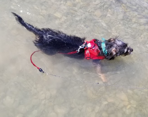
There are a few places to walk there, but the biggest draw is the Guadalupe River, just like it says in the name. Today, Evelyn and I took the dogs up there to start to expose them to swimming. We got each of them to swim a bit, but none of them seemed really enthusiastic.

Mila swimming in the Guadalupe River. Will she ever like it? Dunno. But if I ever take her on, I don’t know, a boat or a dock and she falls in, at least she’s able to keep afloat. I played around with the levels on this photo, but ended up just leaving it as-is.

We then walked around in the park for a while to lessen the possibility of wet-dog smell in the car, and once the dogs, and my sandals, were dry, we headed home.

We definitely intend to take the dogs back to the river. We’ll being chairs and snacks this time (Evelyn has a canopy/pavilion thing we can sit under, too) and be prepared to hang out for a while. Maybe a few trips like that will have them more eager to spend time in the water.

Gratuitous Amazon Link time. Today we have Holes by Louis Sachar. I’d always heard great things about Holes, but couldn’t get focused enough to read it until I saw it in Half Price Books on my annual trip to buy myself a Christmas present. Unlike some of my annual Half Price Books books, this was definitely worth it.

I Went Looking for the Southern End of the North Salado Creek Greenway Today

I hadn’t touched my Howard W. Peak Greenway System project in ages. In fact, I wasn’t entirely sure where I’d left off. I remembered starting out at Lady Bird Johnson Park and going north toward McAllister Park (and I think I made it all that way). I also started from the Oakwell Farms Trailhead and went some direction (probably north towards Lady Bird Johnson Park) but didn’t get very far. And that was it.

So since I wasn’t sure how much of the area I’d actually covered, I figured that my best bet was to start at the far end (since that would be a new-to-me park) and go north, seeing if I could make it all the way to Lady Bird Johnson Park.

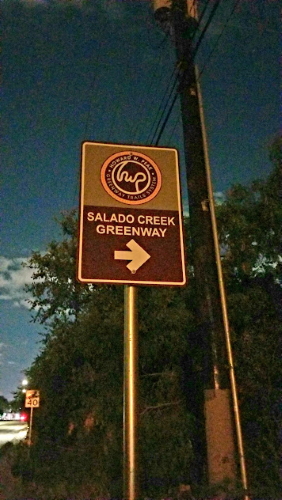
So I drove to John James Park (named for a surveyor who helped set up a bunch of local towns including Castroville) and didn’t see a sign like this:

The Greenway sign outside of Walker Ranch Historic Landmark Park. The coloration is imperfect because I took this picture at 10:00 at night.

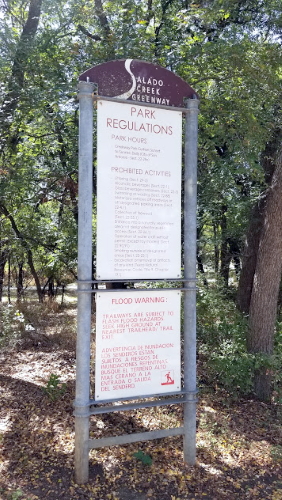
Or like this:

The park rules for the Greenway system. Since there wasn’t one at John James, this is from Lady Bird Johnson. As I say below, it was hot today (and I had done a lot of walking), so I wasn’t about to drag myself down Nacogdoches Road looking for the above Greenway sign during the daytime.

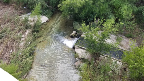
So I walked around the park and also down the street until I crossed the creek (which looked like this):

Do you see a sidewalk in this picture? I don’t see a sidewalk in this picture.

Finally I decided that maybe the greenway ended on the other side of the bridge that carries Rittiman Road over the creek (and also over Holbrook Road)*, but there was no crosswalk in sight and it was over 90 degrees Fahrenheit (32 degrees Celsius) so I wasn’t going to go wandering around out there in the sun any longer than I had to. I also had a very strange conversation with the lady at Via Metropolitan Transit where I explained that I wanted to know how to get to the downtown lineup from the AT&T Center (I’m going to the Maluma concert on Saturday) and after leaving me on hold for nearly nine minutes she came back and told me where the downtown lineup is. Crap. I should probably do a post on taking the downtown Via lineup, shouldn’t I? Well, it’s 11:30 and I have to be up in 9 hours so I’m not going to write it tonight.

After exploring the park a bit more, I decided to drive along Grantham Road looking for greenway signs or, more importantly, parking lots. When I didn’t find anywhere to park, I decided to head up to the Oakwell Farms trailhead and walk down to John James and hopefully find the trailhead from that direction. I got there and found that they were doing sewer work and the parking lot was closed.

So I went back all the way to Lady Bird Johnson Park and decided to head all the way down to John James. When I got to Robert L.B. Tobin Park, just past 410, though, I found that not only was the parking lot closed, but the greenway itself was closed, too.

So after briefly flirting with the idea of seeing if I could get close enough to the Pokemon Go gym to take it over (the Pokemon in there had been there for over three days and I’m sure their trainers would have liked them back), I turned around and headed back to my car. I stopped off at both Hardbergers and did some shopping at the Walmart on Blanco and when all the dust settled, I had visited five parks (I count both ends of the blocked-off part of the greenway as half a park each) and done more than seven miles of walking today.

*The satellite photos on Google Maps seem to show just that happening. I still don’t know how to get *down* there, though.

Some Lives are Wilder Than Others

And my life’s not very wild at all unless you count taking the subway in foreign cities. I guess that could get kind of wild, but so far it’s just been transportation.

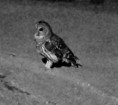
However, while my life isn’t wild, I’ve been close to some whose lives are very wild. This guy, for example:

He looks pretty wild to me!

I saw this fella on April 20 at Walker Ranch Park. I took two pictures, this one and one zoomed farther out, and then I began to worry a little because he was just sitting on the ground. I asked him (really, literally, in actual human speech) why he was sitting on the ground, and he flew off. That was a huge relief to me.

And he’s not alone. In addition to my nearly daily encounters with deer in the parks around here, I’ve recently seen an armadillo at Walker Ranch Park, a rabbit and what I’m pretty sure is a red-tailed hawk at Hardberger Park, and just today what I’m also pretty sure is a crested caracara in Shavano Park (that’s a nearby suburb).

I have pictures of most of them, except the caracara, because I was driving when I saw him. That’s also why I’m not entirely sure that’s what I saw. Whatever it was, it was hanging around with a bunch of vultures that were eating something that looked like a dead squirrel, and caracaras do eat carrion, so that seems like a good indication to me. My first impression was that it looked kind of like a Pokémon, too, and the caracara does kinda/sorta look like a Staraptor, in a way.

I was really thrilled to see the rabbit, too, because I grew up in a neighborhood that had rabbits every-damn-where and I haven’t seen a single rabbit in my entire time in Texas. The last time I saw a rabbit was during a visit to my old apartment complex in Chicago in what would have been 2008/2010 at the latest.

I’m not entirely sure why I’m seeing more wildlife lately. Maybe there’s some construction or other development that’s flushing them out (if so, why am I mostly seeing them in parks?) Maybe they’ve been there all along and I’m just noticing it more?

But, perhaps, the most important question of all, is my old eBird account still active?

Japanese Tea Garden, San Antonio, Texas

As I’ve mentioned before, the site that’s now Brackenridge Park used to be the headquarters for the Alamo Cement Company. The limestone was quarried on-site and when the “carpetbagger” George Washington Brackenridge donated land to the city and the widow of the founder of the Pearl Beer company, Emma Koehler, followed suit by donating some adjoining land, the city ended up with a decent number of old quarries to do something with.

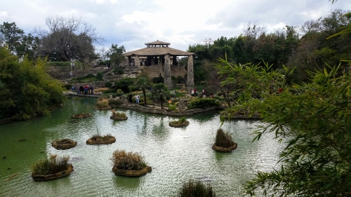
Japanese Tea Garden, 2018
An overview of some of the Japanese Tea Garden, looking toward the pavilion/pagoda thing.

The city parks commissioner at the time, Ray Lambert, decided to turn this particular quarry, which was right behind the cement company, into a lily pond. The lily pond project got bigger and bigger until it became a full garden with ponds and the city invited Kimi Eizo Jingu, a Japanese-American artist, to move into one of the buildings with his family, where they ran a restaurant. The Jingu family was disinvited to live there in 1942, while we were at war with Japan (and, indeed. had confined a large number of Japanese-Americans in internment camps).

At this point, they changed the name of the garden to the Chinese Sunken Garden, and moved a Chinese family, the Wus, into the house. The Wus lived in that house for around 20 years.

Eventually the city got over World War II. They changed the name back to the Japanese Tea Garden in 1984.

I moved to San Antonio in 1993 and the garden had fallen into disrepair by then. Thomas and I hiked out there on a whim when we were in Brackenridge Park to visit the zoo. Someone else was with us. It was a long time ago and I cannot remember if it was our friend Frank or my parents. Maybe it was one of Thomas’s parents. Well, my dad says it wasn’t them, so that leaves Frank or Thomas’s folks.

Anyway, when we got out there we were underwhelmed. I don’t even remember if there was water in the ponds, it was so bad.

Then, in 2007, they began a major renovation project. They rededicated the gardens in 2008 and it’s well worth the stop now. There are koi ponds and walking paths, and a really lovely artificial waterfall. There are also signs warning visitors not to release fish into the ponds and Alex and I joked about putting kraken and such into it.

The building that the Jingu family lived in is now a restaurant (and I’m ashamed to admit that I’ve never eaten there — the one time I tried, it was January and they had some kind of weird abbreviated winter hours).

The Japanese Tea Garden is not what you’d call handicap-accessible. The paths are narrow and there are steps everywhere. One can sit in the covered pagoda area and see pretty much everything. My understanding is that the Jingu House is handicap-accessible.

Gratuitous Amazon Link time. This actually looks like something I might want to buy. Since the Japanese Tea Garden is so tied up in San Antonio’s history, I looked for San Antonio history books and found San Antonio: Our Story of 150 Years in the Alamo City, by the Staff of the San Antonio Express-News.

San Antonio Area Parks: Orsinger Park, San Antonio

I considered revisiting Orsinger Park the day I visited MacArthur but then I realized that I really didn’t need to because I still go there fairly often, largely to play Pokémon Go these days.

But Orsinger has always been one of the parks we visited fairly frequently when Alex was young because it’s the only park we’ve found so far that had a sandbox. Orsinger was the sandbox park, Walker Ranch was the airplane park (because it is in the landing pattern for the airport), and Cibolo Nature Center (have I written on that one yet?) was the dinosaur park (because it has a cast of the dinosaur footprints found near Boerne Lake).

Orsinger is one of the parks of the Bexar County Park system. The land was donated to the county by Genevieve and Ward Orsinger in 1980. Genevieve was a dancer and a teacher (the Genevieve and Ward Orsinger Foundation website doesn’t say what she taught, but since her degree was in physical education, my guess is that she probably was what is colloquially known as a “gym teacher”). Ward owned a car dealership.

Orsinger is a nice little park with a playground and a pavilion with an attached kitchen and a surprising amount of walking trails. The first time Thomas, Alex, and I left the playground area for the walking trails we kept expecting to come to the end of trails but we didn’t. I mean, of course we eventually did, because we’re not still walking around out there, or we didn’t die of dehydration or anything, but there were still a lot of trails.

And I just realized that I don’t have any pictures of Orsinger. I figured that I’d gone on a photographic trip there at some point, but I guess I was mistaken. So I’ll be taking a trip out there and editing this post later, I guess.

Orsinger Park Path 2018
Finally. A picture. This is just a little bit of the walking path at Orsinger Park.

I almost forgot my gratuitous Amazon link. This time the highest-ranked book I can find is Dirt Cheap Photo Guide to Grand Teton National Park by Jeff Clow.

San Antonio Parks: MacArthur Park

On my master list of parks, I say that not all of the parks in the San Antonio area are actually owned and operated by the City of San Antonio. This is one of those other parks, which is owned and operated by Bexar County. And it’s quite a bit larger than I expected it to be. The entrance to the park is on the access road for Loop 410 so I figured I could cover it in 15 minutes. I stayed for almost 45. I was also there late in the day, so many of my pictures are slightly overexposed.

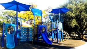
One of the playscapes at McArthur Park.

McArthur Park has several picnic pavilions and a bit of walking path, but the main feature of the park seems to be playgrounds. The park has three of those playscapes where all of the equipment is connected into one big sort of piece of park furniture and there are additional pieces of playground equipment including swings and a small monkey bar thing that looks like a flying saucer. I found that last one particularly interesting, but couldn’t take pictures of it because there were someone’s kids on it and taking pictures of other people’s children is considered to be kind of creepy. Maybe I’ll return someday and get a picture of that.

Have you played the “You are Jeff Bezos” game? The point of the game is to demonstrate just exactly how much $156 billion is. You wake up as Jeff Bezos and you decide that maybe if you spend all of his money you can get back to your own life. I’m not 100% about the things that the game designers think are priorities. For example one of the options is to revive Mythbusters. I’ve seen like two episodes of Mythbusters and have heard of a bunch more and I’m just not a fan. I’ve just never believed that the five-second rule really means that it takes five seconds for germs to attach to an item dropped on the floor. It’s more a winking “if you fix it fast enough it never happened” thing, I think. So watching two guys drop things on the floor and measure the germs on it just doesn’t seem like gripping television to me.

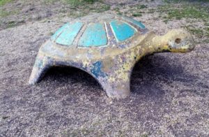
sad turtle, mcarthur park, san antonio
Concrete turtle in need of repairs, 2018

What I would like to spend a bunch of Jeff Bezos’s $156 billion on is fixing up parks. And McArthur had a bit of stuff that I’d like to fix. For example there are several pieces of concrete art that need a bunch of TLC. The paint is peeling (or has peeled) off and in several cases there are actual chunks of concrete missing. I really do wonder how much it would cost to paint and repair those poor things, if Bexar County would take a donation for that purpose, and if I could write it off of my income taxes.

Now I need an Amazon link. Does Amazon have some kind of “pick a random book” feature? I guess I’ll try to come up with my own. So, searching for “Parks” and sorting by customer reviews, the first result is Urban Trails: San Francisco: Coastal Bluffs/ The Presidio/ Hilltop Parks & Stairways by Alexandra Kenin. I guess that’ll hold me for this post, particularly since seeing the San Francisco area is years away at this point unless this blog thing really takes off or I win the lottery.

More Pondering San Antonio Parks

So I’ve decided that rather than futzing around with a map (and my spellchecker liked “futzing.” Who knew?) I’d just copy the list from the city website. And messing with the list makes me think that maybe futzing with a map would be easier. Dear God.

Ultimately, once I remove all of the formatting and the extraneous stuff like addresses and photos, I’ll maybe bold the ones I’ve been to and change the colors of the ones I’ve written up? Or maybe pretend I’m using a highlighter and turn the ones I’ve been to blue and the ones I’ve written up green or purple? Or maybe use pink and orange, so that it looks less like links. I think I like that.

So ultimately,

Friedrich Wilderness Park

Will turn into

Friedrich Wilderness Park

once I’ve visited it and

Friedrich Wilderness Park

once I’ve written it up?

Should I pick a different shade of orange?

Friedrich Wilderness Park

Yeah. I like that darker orange better.

Now, once I’ve cleaned up the list what should I do with it? For reasons I don’t understand, school playgrounds are on the list now — this makes me a bit nervous since, well, school property. I think I’ll remove them from the list as I go.

Should I put them on my “about” page? Add a new “about”-type page for this list? Make it a blog post with a special tag?

I think that probably the new “about”-type page would be best so that *I* can find the list pretty easily. I don’t want to lose it and then have to recreate it again.

Now if you’ll excuse me, I have to go remove photos from the “L”s.

P.S. It just hit me. Once I’ve finished this list and all of them are orange, I’ll have to go back through the official city list because I’m pretty sure that they’ll’ve added new parks in the however-long it takes me to go through the whole list.

This is what’s known as job security. Or would be, if I were making any money from this yet.

The 2018 San Antonio March for Science

On April 14, 2018, San Antonio held its second annual March for Science. The 2017 march wasn’t as well attended as I would have liked and the 2018 march had, from what I could tell, even fewer people. I haven’t yet been able to find any official numbers of attendees for this year, though.

2018 March for Science attendees
Some of the marchers. You can probably see what I mean about the sparse attendance.

We started out at Thomas Jefferson High School, the third-oldest high school in the city (the first two were evidently the Main Avenue High School (which is where CAST Tech High School is today) and Brackenridge High School (which is on Eagleland in between St. Mary’s and the San Antonio River)). A large number of famous San Antonians attended Jefferson High School including the Castro brothers — Joaquin (a US Senator) and Julian (the former mayor and who was Obama’s HUD secretary) and two Nobel laureates — Robert Floyd Curl, Jr (namesake of Floyd Curl Drive in the Medical Center area? Perhaps) and William E. Moerner.

Jefferson High School has a lovely building, which is on the National Register of Historic Places.

Thomas Jefferson High School San Antonio, Texas, 2018
Jefferson High School. I actually like this one pretty well.

The Motorsport team from San Antonio College was there showing off the car that they were entering in the Shell Eco-Marathon in East Petaluma, California.*

The opening remarks were given by Ron Nirenberg, the current mayor, and then we marched down to Woodlawn Lake Park, sort of buzzed the park a bit, and then back to the high school. The march didn’t get much attention in the media, so only a couple of people came out to watch us (we also were watched by, and waved at, some roofers who were working on one of the houses in our path). I listened to the speech by the faculty sponsor for the Motorsport team, took some pictures of the building, and then hung around until I started to see people leave.

It was a very enjoyable march. It’s nice to get out with people who share the kinds of interests that I have. I just wish that there had been more promotion of the actual march, so that more people would have turned out for it and maybe we would’ve gotten more spectators.

*They won first place in a design award and fourth in the actual race.