Alex and I took a trip to Chicago on August 8 through 11, 2016. Partly the trip was because I was homesick; I hadn’t been home in six years. But part of the trip was because my now-ex has most of our photographs from our previous trips to Chicago. I started writing about Chicago destinations in past posts, but since my ex has the pictures, I couldn’t post any pictures with them.
So here are a few pictures that I will, ideally, be moving to those posts, and probably a few more that I’m particularly fond of.
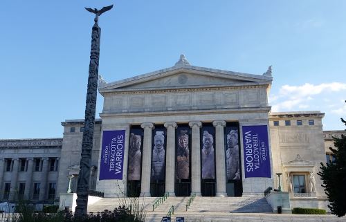
First, is the Field Museum of Natural History. Arguably my favorite museum in Chicago (if it’s not my favorite, it’s a very, very close second to the Art Institute of Chicago). I’m not sure which image(s) I’m going to use, so I’ll post three of my favorites here. I reserve the right to come back and say, “Ooh! Here’s another nice one!” at some later date.
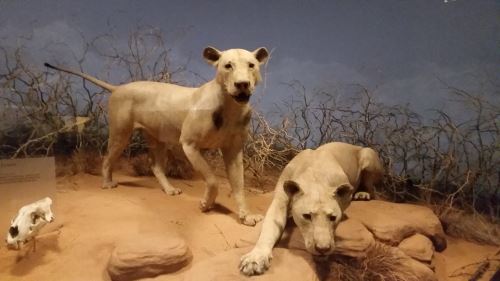
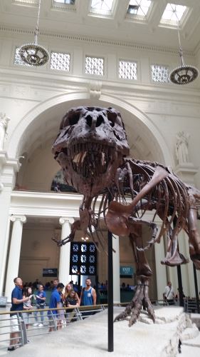
The Field Museum of Natural History, Chicago, Illinois, 2016. Alex and I were in the Museum Campus until after the museums closed so I was able to get this nice photograph of the north entrance without any people in it.The Lions of Tsavo, two of the most famous “residents” of the museum. These lions (well, the lions that used to wear these skins) killed and ate around 35 people in Tsavo, Kenya, in the 19th century. The lions’ skulls are also on display in the same case. You can see one of the skulls there in the lower left-hand corner.Sue the tyrannosaurus rex. Sue is yet another popular “resident,” visible in Stanley Field Hall
Millennium Park was my next post, so here are a few of my favorites from there. I will definitely include the first image because I attempted to describe it in the post and failed miserably, so why not include a photo?
The back of the plot of land that eventually became the westernmost part of Millennium Park had a wall similar to this along the back of it.
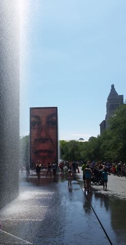
I spent several minutes trying to find the best reflection of the skyline on the Cloud Gate (also known as the “Bean”), but didn’t find any that really spoke to me. Maybe later, after further examination, I’ll find one, or maybe I’ll just have to make the sacrifice and go back to Chicago at some point other than the height of the tourist season (imagine a fake sigh here). So, instead, here’s one I really liked of the Crown Fountain.
Crown Fountain, Millennium Park Chicago, 2016
I think I’ll stop here for now and return to this topic in two weeks or so with photos from the Art Institute of Chicago and Grant Park, also perhaps of Lincoln Park, though most of those pictures I took were of the zoo, which I haven’t posted on yet. And then, two weeks or so after that, we’ll go forward with (in two-week increments) Lincoln Park Zoo, the Adler Planetarium, the Shedd Aquarium, the Chicago Botanic Garden, and some of the highlights of Chicago architecture. We should be in November by then.
I’ve run some numbers and it looks like I’ll be able to return to Chicago to take photos of the Museum of Science and Industry, the Oriental Institute and perhaps some suburban destinations, in 2018 or 2019.
I don’t know how long my discussion of Yellowstone will turn out to be, so I’ve tentatively labeled this as Part 1.
Alex and I got kind of a late start on our first day at Yellowstone. The drive from Salt Lake City had taken a lot longer than we had expected. In addition to the two hours of scheduled stops, and the unscheduled more than an hour Rocket Display stop, I forgot my rescue inhaler, so we had to transfer it to a Walmart in Idaho and wait for it to become ready. I estimate that rather than taking four or five hours, it took eight or nine. At this point, I was not in a rush to get back in the car, even though I thought that I’d get plenty of time out of the car at Yellowstone.
I didn’t get lots of time out of the car at Yellowstone. Let’s put it this way. San Antonio is the 67th largest city in the world in terms of land area. You could drop San Antonio on top of Yellowstone (not that I’d recommend this) and still have lots of space around the edges (19 miles all the way around, if my math is correct). So, yeah. Unless you book a bus tour, expect to spend lots of time in the car.
Overall, I have to give Yellowstone a solid four out of five stars for producing megafauna to gawk at. Minutes after entering the park, we saw our first bison. By the time we left Yellowstone heading for Dinosaur National Monument, we saw even more bison (including several herd of bison in the distance, one ahead of us blocking traffic, and one alongside the road so close to our car we could hear it breathing — that was unnerving), a black bear (which was too close to the road, but we stopped and took a couple of pictures anyway, a grizzly bear (likewise), at least one yellow-bellied marmot, and at least one elk (or maybe one elk and two moose cows, or possibly two elk and one moose cow). I think I saw some pronghorn antelope in the distance once. We also heard something howling on two separate occasions (I’m not sure if they were coyotes or wolves). No dall sheep or actual sightings of wolves, and also it would have been nice to have gotten a picture of the things that I thought might be pronghorn. If I’d gotten those squares on my megafauna bingo card, Yellowstone would have rated five out of five.
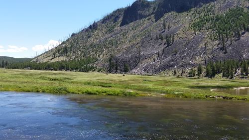
Believe it or not, that brown lump pretty much right in the center of the image is a bison. I also have some closer photos of it, but I wanted to share just the tiniest bit of the scale of the park as well. The water in the foreground is the Madison River.
We chose not to go to Old Faithful first because Alex wanted to do some stargazing and I read several things that said that the area around Old Faithful is a good place to stargaze, largely because there are people there pretty much around the clock. Since it was just the two of us, I figured that keeping to populated areas after dark would be a good plan. As it turned out, 81% of the moon’s disk was visible that night, so the light pollution from the moon ended up causing us difficulty with the stargazing. I still owe Alex a stargazing trip.
Back to that morning. We’d heard that there had been snow at the higher elevations in Yellowstone, so since we started out kind of hungry, we chose to eat at the Canyon Village, which is the highest in elevation (I hoped that perhaps Canyon Village would be close enough to the highest elevations that we could see if there actually was snow up there and maybe find a route up to it). We ended up eating sandwiches at the deli and while they were, you know, sandwiches, and not terribly exciting as cuisine goes, the people there were very pleasant and helpful. This set a very nice tone for the day.
After we ate, we stumbled across the Grand Canyon of the Yellowstone, which is a place where the Yellowstone River cut into the rock and, well, created a canyon (just like it says on the tin). We found, and spent entirely too much time photographing, the Lower Falls. We saw a boardwalk that led down towards the river and, because I’m too adventurous for my own good sometimes, I convinced Alex to go down there with me. The trip down was great, but the trip back up was a bit strenuous. Just a year ago, he and I had climbed the Statue of Liberty with no problem, so I was sort of distressed about just how difficult I found the walk back up. However, the elevation of the Grand Canyon of the Yellowstone is around 6,000 feet, so perhaps that made at least some of the difference.
After this, we went in search of even higher elevations, which led us up into the northwest corner of the park. I didn’t want to attempt to climb Mount Washburn. Oh, who am I kidding? I probably would have totally been up for it (despite the adventure I had coming back up at the Grand Canyon). Alex talked me out of it. Mount Washburn was probably our best shot at seeing snow on this trip, too. Oh, well, maybe it’ll snow in Dallas this year and we’ll luck out and be able to go up to Dallas to see it.
While we were in that corner, we drove into Fort Yellowstone, where we saw an animal that I at first identified as a horse. Alex was taking pictures of it, and I asked him why he was taking pictures of “that horse.” He told me that it clearly was not a horse and later, when I looked at the pictures, I think it might have been a moose, though it was more of a yellow color than I was expecting. Looking at other pictures of moose and elk, maybe it was an elk.
We parked and kind of knocked around a while at the Mammoth Hot Springs area (and I would like to go back and stay at the Mammoth Hot Springs Hotel some fall or winter) and took a lot of pictures of the thermal features there.
At this point, it was getting pretty late and we were looking at an hour and a half drive, so we headed towards Old Faithful. We took even longer than that, because we found a whole area of thermal features that needed to be explored and photographed.
Finally, with the sun beginning to sink in the west, we headed for Old Faithful. We got there just after an eruption, so we had an hour or so to kill, and during that time, the sun went down almost completely. I took some photographs of the geyser before the sun went down and then again afterwards (I also videoed the eruption, but my phone camera is not fantastic at night photography, so the video is mostly whooshing noises and blackness). We stuck our heads into the Old Faithful Inn (I had wanted to visit the Inn because I remember the 1988 wildfires that came *this* close to threatening the Inn). We then went to the Old Faithful Lodge and got a drink and two huge cookies to eat while we waited.
One of the nice things about watching Old Faithful erupt after nightfall is that almost no one is there. We had fantastic seats. And the geyser gave us a nice several-minute show. After the eruption we looked at the stars for a bit, but I wasn’t sure if they really would let us out of the park that late at night, and we still faced a 45-minute drive (during daylight hours — we were driving just a little more slowly because I didn’t want to end up wrapping the car around a moose or something) back to West Yellowstone, so we headed back out. We stopped along the way and looked at the stars again on the way, as well.
And, since we’re at over 1,000 words, this looks like a good place to stop for now. So I will end up with at least two posts on Yellowstone. We’ll meet here in Montana/Wyoming again on September 3, I think?
I’m trying to remember how my ex-husband and I discovered Friedrich Wilderness Park. I do remember that we accidentally wandered into Raymond Russell Park the first time we looked for it (but didn’t get very far into Russell Park at all — I finally explored that one fully just this year). Friedrich Park ended up becoming one of our favorite parks, though, and we introduced both friends and family to it over the years.
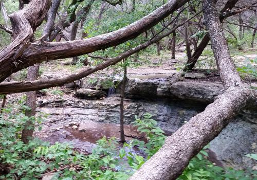
Friedrich Wilderness Park, San Antonio, Texas 2015
The original land that made up the park was a bequest of Norma Friedrich Ward, who wanted it to be preserved as a natural area and named for her parents, Emilie and Albert Friedrich. Later, two men, Wilbur Mathews and Glen Martin, donated another 52 acres. Interestingly, though, despite its status as a natural area, Friedrich Wilderness Park is not untouched by human hands. I’m not talking about paved paths and the addition of bathrooms and a classroom. A stream passes through the park and where the stream intersects with the Main Loop Trail (and for a while out into the wilderness from there), the stream bed is concrete or cement or something like that. I’ve never been able to figure out how that stream bed got paved or why someone would pave the stream bed.
Friedrich Wilderness Park has eight miles of walking trails, most of which are not accessible to those in wheelchairs. Friedrich is where I first saw the path levels that are used in San Antonio. There is a loop path near the entrance that is level 1, but most of the other paths are level 3 or 4.
Friedrich Wilderness Park is also a nice place to go if you are a birdwatcher. It is one of the nesting sites for the Golden-Cheeked Warbler and the Black-Capped Vireo. Of course, other birds are seen there as well. Unfortunately for me, the Golden-Cheeked Warbler nests in “mountain cedar” (actually a type of juniper) trees, so the park is rife with them. Mountain cedar is a really bad asthma trigger for me, so I need to make sure I bring my rescue inhaler, particularly during the winter, which is when the trees release their pollen. Many people in San Antonio face a different, but related problem, which is more traditional “hay fever”-type allergies from mountain cedar pollen, so take any allergy medication before going.
Ghost Lands, by Paul Salopek, photographs by John Stanmeyer
We return to Salopek’s Out of Eden Walk series for the first time after a pretty long hiatus. The Out of Eden Walk was originally supposed to take seven years, but it looks like it may take longer. The last time I checked the map showing where he was expected to be, he was a little bit behind schedule. I found the map and he was supposed to be in India in 2015 and then in China at some point in 2016.
So far he’s made it to the border between Turkey and Armenia and in this article he shares with us some of the fraught history between those two countries. During the last days of the Ottoman Empire (which lasted until 1922), over a million Armenians were killed in what Salopek says that “most historians” say is “the modern world’s first true genocide.” The official Turkish version is different, of course; they say that 600,000 were killed and that they were more along the lines of “collateral damage” than an attempt at extermination.
Salopek shows us the remaining damage to both the land and the people as a result of the deaths of these Armenians. The border between the two countries is closed and there is basically no way to get directly from one country to the other except for one airline that flies out of Yerevan. By land, the only way to get from one to the other is to go hours out of the way through Georgia.
93 Days of Spring, by Jim Brandenburg
Brandenburg shares with us his project to take one photograph a day in Minnesota during the spring. Brandenburg didn’t choose Minnesota randomly; it’s his home. The photographs are beautiful, as one would expect from a professional photographer. They also show a love of his home that, hopefully, will inspire other photographers to take pictures of their own homes.
As an aside, taking pictures close to home is a particular interest of mine. Some of the important things from my childhood and youth are no longer there and I never got to take a picture of them. I’m always after Alex to photograph the things and places that are important to him because you never know what may happen in the future and he may want to share these things with his own family someday.
I have to admit that I keep forgetting what year it is. I work as a pharmacy technician and, as such, I have to keep an eye on expiration dates for the medications and if they expire in less than a year I have to change the expiration date on the label to match. Somehow, this ends up with me thinking that it’s a year ahead of when it really is. As a result, I may end up labeling some of these as being in 2017.
Anyway, back to the subject at hand. Alex has always loved vehicles. He now is into spacecraft and airplanes, but trains, cars, trucks, he’s really fond of them all. So when I was planning this trip and someone told me that the site where they drove in the golden spike that completed the transcontinental railroad was just north of Salt Lake City, I had to add it to our itinerary, even though it would slow us down by at least an hour. The original drive from Salt Lake City to Yellowstone was only about four and half hours, so what’s an additional hour between friends, right?
Well, first we made the stop at Great Salt Lake State Park, so that added another hour to the trip, so instead of the five and a half hours I was expecting, we ended up at six and a half hours. But I live in Texas, so spending six hours or so behind the wheel of a car in one day is nothing new. Although, admittedly, those six hours are usually a round trip and not just the outward trip.
So now we’re looking at a six and a half hour trip. But then as we’re heading out on route 83 on our way to Golden Spike, we pass a sign that says, “Rocket Display.” Alex wants to see it, and my first instinct is that it’s going to turn out to be some old man with random parts in a barn or something, but I agree to go, so long as it’s not too scary when we get there.
Turns out that “Rocket Display” is a rocket garden in front of the offices of Orbital ATK. Many of them were more missiles than rockets (and I tend toward the pacifist, so I was not terribly enthusiastic about that aspect of it), but Alex loved it and took at least one picture of everything in the garden. They did have the rocket booster from a space shuttle, which is really a challenge to photograph well, I’ll tell you.
After an hour (maybe longer), Alex and I were back on the road to Golden Spike National Historic Site. We got there around 3:00 p.m. and, if I’d been willing to hang around in the heat (or in the gift shop) for a full hour, we could have seen them put one of the replica engines in the shed.
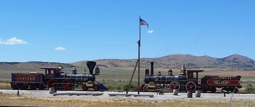
The replica engines at Golden Spike National Historic Site, 2016
I kind of wish I’d gone to Golden Spike when things were slightly less, you know, hot so that we could have seen the engines move back into their shed. Despite what I was told about the desert feeling less hot because it’s a “dry heat,” it still felt like we were standing under a heat lamp out there to me.
Most schoolkids learn the story about the transcontinental railroad in school in the United States. The Union Pacific Railroad started construction from the Mississippi River heading west and the Central Pacific Railroad started construction from Sacramento heading east. When they met at Promontory, the heads of the two railroads held a big ceremony when a literal golden spike was driven into the track and into a tie made from laurel wood. Immediately after the spike was driven, by the way, they pulled both the spike and the tie out and replaced them with an ordinary spike and tie. The original golden spike is on display at Stanford University.
There were a number of things that were on display at the site that were interesting. Apparently when they changed from iron to steel rails, they changed the shape of the rail. There is a piece of what they claimed was the original rail from that section of the track on display there, despite most of the track having been sent to be recycled for the war effort during World War II. There is also a monument to the Chinese workers who built the railroad. And there are a number of historic photographs. I love historic photographs.
Most of the site seemed like it ought to be accessible to wheelchair users. There is a part of the site that is on the other side of the tracks, and there is a kind of ramp over the tracks. The other side is unpaved, however, and aside from a few interpretive signs, the only thing on that side is two wooden staircases that take one up to look inside the replica engines. I don’t recall them having any kind of ramp, however, so that part is probably not accessible.
Every Last One, by Rachel Hartigan Shea, photographs by Joel Sartore
In my last National Geographic post, I said that this article will also be tangentially about death. And extinction, cancer, John James Audubon painting the portraits of dead birds, there’s a lot of death, and potential death, going on here.
Joel Sartore is a photographer who used to travel all over the world, until his wife, Kathy, developed cancer. Sartore needed to be there for her and to take care of his kids, so he stopped traveling for his work. Using John James Audubon as his inspiration, he decided that he wanted to start taking portraits of animals. As you may or may not know, Audubon was drawing, which takes longer than photography, and he needed his subjects to sit still longer than they would in life, so every bird that Audubon drew was dead and wired into a natural pose.
Sartore contacted a friend who worked at a local zoo and got his friend to lend him a white box and a naked mole rat. And thus Sartore’s new career was born. Some of the animals that Sartore is photographing are endangered, some even critically endangered. Sartore photographed one of the last five northern white rhinoceros in the world just before she died. Sartore’s photographs are amazing. In this article, we see 77 of his photographs. Sartore estimates that it will take 25 years to finish photographing just the species that are in zoos. He may not live to see that part of his career finished.
Oh, and Kathy had another bout of cancer in 2012, but has been cancer-free for four years now. His son, Cole, had Hodgkins lymphoma in 2012, but Hodgkins lymphoma is curable, so his prognosis is excellent.
Urban Parks, by Ken Otterbourg, photographs by Simon Roberts
If you’ve been reading here very long at all, you’ll see that I really love urban parks, so this article was right up my alley. Otterbourg traces the origins of some of our urban parks, mostly focusing on lands that have been reclaimed from other uses, including the rebirths of the Cuyahoga and Chonggyecheon rivers, the creation of the Golden Gate National Recreation Area, and other parks.
I’m disappointed that Millennium Park isn’t listed here. The creation of the park above a parking lot and old railroad lines seems right in keeping with the “reclaming land to make parks” theme of this article. Speaking of which, it’s August, so it’s only about two months before I return to walking San Antonio’s own reclaimed-land park, the Peak Greenway.
We’re home from Chicago, so I will probably resurrect my Northern Illinois Destinations topic soon. I’m not entirely sure how many of the places we went I haven’t covered yet, but I got a lot of pictures of places that I have written. And I mean a lot, a lot, like over 600 total pictures. So I will probably start with a post sharing the pictures that I will eventually go back and insert into those posts. Then we’ll start tackling places that I haven’t covered. I probably will also do a post on some of my favorite buildings that are not really places to go for an activity, but things to see.
Next up alphabetically is Denman Estate Park, but we’ve already covered that one. So onwards and upwards to Eisenhower Park.
Eisenhower is a lovely park built on one of the foothills of the Texas Hill Country. I went there once with the now-ex when Alex was little, but I had a terrible asthma attack at the top of the hill and was afraid to go back after that. I was sure that everyone around me could hear the wheezing, it was so bad.
Now that I’m taking asthma maintenance medication (whoever came up with the combination of inhaled steroids and long-acting beta agonists really needs to be canonized), I can visit Eisenhower Park whenever I want.
The land which is now Eisenhower Park was originally part of Camp Bullis Military Training Reservation. Camp Bullis is still there, yards/feet/inches away from the park, depending on where you are standing at the time. Former General and US President Dwight D. Eisenhower was, for a time, stationed at Fort Sam Houston (locally called “Fort Sam”) here. In fact, he met his wife, Mamie, in San Antonio.
Sometime around 1972, the United States Army decided that they needed to reduce the size of Camp Bullis by more than 1,000 acres. They transferred ownership of this land to Bexar County and to the city of San Antonio. In 1988, the city turned their 320-acre share into a public park.
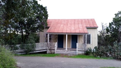
The house in Eisenhower Park, San Antonio, Texas, 2016
Eisenhower Park has picnic facilities, a playground, a house that I think was moved here from somewhere else, and, of course, five miles of hiking trails. Interestingly, no one has put the origin of the house on their website, so when I next go to the park (more on that later), I’ll make a note of it. I thought I got a picture of the sign explaining it but I can’t find one now.
The trails are, for the most part, unaccessible by wheelchair users. There is one paved path that goes pretty much right straight up the hill, but it’s pretty steep. I guess if the wheelchair user in question has really good upper-body strength or a fairly powerful motorized wheelchair you might be able to make it but I really wouldn’t recommend it.
At the top of the hill is a (not at all handicap accessible) observation platform. You can see downtown San Antonio from the platform, but it’s pretty small. Alex and I had tentative plans to go up to Eisenhower Park the Sunday before we left for Chicago, but it never happened. Alex is going to his dad’s for a few days later this week, so I may make the trip myself. I’m going up there because of the view of the city. I’m trying to figure out how to get good pictures of the moon with my cell phone camera and I read something that said that you can use a telescope or binoculars to bring the moon into sharper relief so I’m going to experiment with taking pictures with a telescope (or binoculars) from the top of the platform. The moon is farther away than downtown San Antonio is, but if I can make downtown look bigger from there, it might be worth experimenting with it on the moon.
I’m not overly enthusiastic about reading about death. And for this project, I had to slog through, not just one, but two articles about death. If I were less dedicated to my goal of reading everything, I would have just skipped these two articles.
So I’m going to give you a couple of titles, a couple of authors, a couple of photographers, and a quick rant, and then we’ll be done with this and move onto the title article on Joel Sartore’s photo ark (which is also tangentially about death — I love posting about death 30 hours before I’m supposed to get on a plane, really, as if flying didn’t make me nervous enough).
First title, author, and photographer, The Crossing, by Robin Marantz Henig, photographs by Lynn Johnson.
Second title, author, and photographer, Where Death Doesn’t Mean Goodbye . . . by Amanda Bennett, photographs by Brian Lehmann
And now the rant. The Crossing is about new developments in science where people who were previously thought to be beyond resuscitation were resuscitated (frequently seemingly no the worse for wear). One of the examples they give is Jahi McMath, who, we are told, “experienced a catastrophic loss of oxygen during a tonsillectomy.” If this is the quality of research that Marantz Henig put into this article, then I’m suspicious about the whole thing.
McMath was obese and had sleep apnea. This caused a sort of feedback loop effect where her sleep apnea seemed to be making her gain weight, and her weight problems were exacerbating her weight problems. Finally, in 2013, (and by some accounts, a little reluctantly), the doctor in question operated on her. The operation was not a simple tonsillectomy. The doctors completely resectioned her throat. They removed her adenoids, her tonsils, and I think they did something to her uvula. Looking it up, I see that they resectioned her uvula and her pharynx as well. This is an extensive surgery, and not one to be undertaken lightly.
And McMath made it through safely. I can’t find the reference now, but I seem to recall that she was out of recovery and in ICU (because it was extensive surgery) and was talking with her family when she began to bleed from the incision site (which was in her throat). Then she went into cardiac arrest and by the time they got her heart started, there was no sign of brain activity. The State of California declared her dead. Her mother disagreed with the state because McMath’s heart hadn’t stopped when her neurological functions did and got them to release McMath to her and they moved her to New Jersey, where she has been on a ventilator and a feeding tube ever since.
So it wasn’t just a tonsillectomy (though her tonsils were removed during the surgery), she didn’t have the event during the surgery itself, and there was a bit more going on than just a loss of oxygen.
Next up: More San Antonio parks and then a man who is trying to get a photograph of every existing species of animal.
We actually got back late Thursday night, but I had to (a) pick my cat up from boarding early yesterday and (b) work until pretty late last night, so this is the first time I’ve had it together enough to post.
An untitled sculpture by Pablo Picasso, in Daley Plaza downtown. Chicagoans just call it “The Picasso.”
What I noticed about this photo of the Picasso, for what it’s worth, is how low my perspective is. I mean, I know that I’m short, but somehow I always imagined that I was seeing the Picasso from something like the same angle that it’s usually photographed in, and not from an angle where I would be looking up her nostrils if her nose were three-dimensional (and “her” is correct — the Picasso is, in fact, a sculpture of a woman).
We spent most of the time in downtown Chicago on this trip, but we did go out into the suburbs once, to visit the Chicago Botanic Garden in Glencoe. The trip was only four days, but we visited four museums (the Art Institute of Chicago, the Field Museum, the Adler Planetarium, and the Shedd Aquarium) and three parks (Millennium Park, Grant Park (which we actually visited in two chunks — we walked down the east side of Columbus Drive on our way to the Museum Campus and back up the west side of Columbus Drive on our way back to our hotel), and Lincoln Park (while we were there, we visited Lincoln Park Zoo). I also dragged Alex to some landmark buildings, including but not limited to the Marshall Field and Company Building (which currently houses a Macy’s), the Chicago Cultural Center, the Chicago Board of Trade building, and the Water Tower. I suggested that Alex and I go into Water Tower Place (a shopping mall across the street from the Water Tower), if only for the air conditioning, but he didn’t want to.
I took over 600 photos and saw two childhood friends while I was there. It’d been six years since my last visit and I don’t want that much time to pass again. One of my friends and I almost didn’t recognize each other, it’d been so long since we’d seen each other. I’ve started a fund to save up for another trip back. I’m thinking that we may rent a car for part of the next trip (which looks like it’ll be late in 2018 or early in 2019) because I’d like to take Alex to see the Black Hawk statue in Lowden State Park and Grosse Point Lighthouse in Evanston, both of which would be much easier to visit with a car.
I try to visit all of the famous bodies of water that I can make it to when I travel. In 2014, Alex and I went way out of our way to see (and for me to dabble my feet in) the Mediterranean. So, I had to at least see the Great Salt Lake. I had two choices of destinations to visit the lake, Great Salt Lake State Park and Antelope Island.
Antelope Island looked as though it was more “on our way” than Great Salt Lake State Park, since it’s northwest of the city and we’d be traveling northward on our way to Yellowstone, but when I put them both into Google Maps, I realized that Great Salt Lake State Park was actually significantly closer, because to get to Antelope Island, you actually have to go north and then back south again. So, since we were facing a seven-hour trip (six hours if we were going direct, but we were planning to stop in Promontory to visit the Golden Spike National Monument), we opted for the easier-to-access destination.
The Great Salt Lake, 2016. The water was particularly low this year.
So we headed out. After a brief stop at the store for provisions, we hit Interstate 80 towards Magna. It turned out that Great Salt Lake State Park was probably the better choice for two reasons aside from the shorter commute time.
First, I had read about Saltair, a Victorian-era resort where Mormon dating couples could go swimming and dancing without worrying about their reputations because there were Mormon chaperones everywhere. I did not realize that Saltair had been in that section of the lake. I say “had been” because the original Saltair was destroyed by a fire in 1925. The building at the exit from Interstate 80 is not exactly where the original Saltair had been; the original was two miles farther east, but it was close enough in my opinion.
The second was the Kennecott Utah Copper smelting plant, which is pretty much directly across the Interstate from the park. I had noticed the smokestack (the tallest man-made structure in Utah) from the air, and if we had gone to Antelope Island I may never have known what that smokestack belonged to).
I had read that, due to the brine shrimp and brine flies, it wasn’t really advisable to swim in the water, but when we arrived, I saw people in bathing suits rinsing off under a hose. And I thought, “I’m going to touch that water.”
We nosed around in the visitor’s center for a while and then headed outside. The lake was, well, a lake. There is a lovely little island not too far from shore, and there were a *lot* of brine flies on the shore. There are only two things that live near that water — brine shrimp in the water and brine flies near the shore. However, the brine flies attract (1) migratory birds and (2) spiders. I like spiders, so that part was cool for me.
I didn’t swim in the water (I still had a six-hour (it ended up being even longer) drive ahead of me), but I did wade in up to my ankles. The waves made nice Zen-garden-feeling patterns in the sand. I rinsed my feet off under the hose, but still felt like I needed to wash my hands. The restrooms were kind of dark, but seemed clean enough when I was there.
The observation deck is fully ADA-compliant, as are the restrooms, or so the website of the architect who designed them assures me. Unfortunately I couldn’t find a path down to the water that wasn’t rocky, so that seemed off-limits to wheelchair users.