2017 California Trip — Our Fourth Day in California

We did so much this day, that looking back I’m all, “Are you sure that was all one day?” And, well, I guess it is.

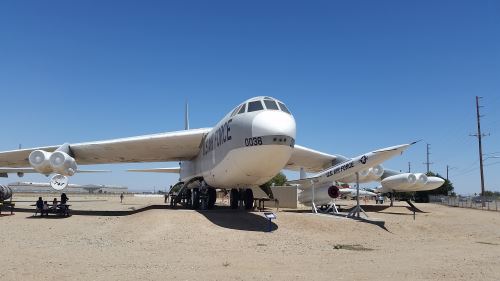
As we’ve covered before, Alex is a vehicle buff. His particular interest is in airplanes, and I discovered that there is a museum, called the Blackbird Airpark, in Palmdale, California, near the Palmdale Regional Airport and Plant 42 Plant 42 is a manufacturing plant that makes vehicles for the Air Force and NASA).  Blackbird Airpark has both types of Blackbird airplanes — the SR-71 and the A-12 (I’m kind of scared that I remember those letters and numbers).

So, in the morning, we headed off to Palmdale. We got there without incident, only when we got to the airpark, none of the planes that we’d been promised were there. They were great planes, including one of the 747s that carried the Space Shuttle, but Alex was still disappointed. Once I went to hide from the heat, I did some research and discovered that we were in the Joe Davies Heritage Airpark, next door to the Blackbird Airpark. I found the open gate between the two, told Alex where it was, and went back to hide in the shade (July in the desert is not Olivia-friendly).

After Alex had photographed everything he could at the Joe Davies Airpark, he came to get me and we went over to the Blackbird Airpark, where I hid in the gift shop/museum while he took more pictures. He came in, got some souvenirs, talked to the workers for a while, and we headed back to Los Angeles.

B-52, Palmdale, California, 2017
The B52 at the Joe Davies Airpark. Everyone sing along with me. “Here comes a stingray . . .” And, yes, I know that the B52s were named after a beehive hairdo, but my fondness for the band led me to take this picture.

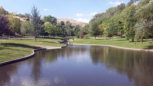
After a two-hour drive, we arrived at Hancock Park, home of the La Brea Tar Pits. we ate lunch at a Vietnamese food truck, then visited the George C. Page Museum*. After we left the museum, we walked around the park and looked at the displays, including the Observation Pit, which was closed when we were there. It’s strange how familiarity can change the way something looks. I swear that Hancock Park has changed a lot since our 1996 visit, but I couldn’t tell you exactly how it’s changed.

Back in the days when Thomas and I used to meet up with friends in Los Angeles, we’d stay at the Sportsmen’s Lodge and would frequently eat at the Jerry’s Deli just down the street. So, since we weren’t too terribly far from there at Hancock Park, we had dinner at Jerry’s Deli (I had to have the chicken noodle soup, which tasted just like I remember it) and left the car there while we hiked up to the Sportsmen’s Lodge, which looks almost nothing like I remember. I know that they’ve remodeled, but between the remodel and the 18-year gap, it looked very different from what I remember, but still similar enough that I was sure we were in the right place.

On the way back to the hotel, I made a big loop, and I’m not entirely sure why. I think that might have been when Alex and I had a miscommunication on which way to turn when and we ended up driving around Arcadia at night. Then again, maybe that big circle is just because the cell towers lost track of us.

*Which is probably going to earn itself its own entry after I finish the travelogue.

2016 Vacation: Our Return to Salt Lake City

The drive back to Salt Lake City from Jensen took a bit longer than Google Maps said it would. This was at least partly due to the fact that I was so over the seats in that car.

Once we arrived back in Salt Lake City, I had three goals: 1. to see the state capitol building (and, at one point, I could have crossed a moon tree off my list, but it is dead now); 2. to see City Creek, which was the water source for the early city (and still supplies water to the city today); and 3. to make it back to the airport in a timely manner.

And I achieved all three.

The trip to the capitol building took us up State Street (which makes sense), which eventually becomes one very lane going uphill. It was near the end of the work day (around 4:30 or so), so I figured that most traffic would be headed away from the capitol. I’m not sure why so many cars were headed towards the building at this time of day, but the road was very congested. This was not my favorite part of our trip, and made me wish we had had a little more time and energy on our first day in Salt Lake City to hike up the hill to the capitol. The view of the capitol building once you emerge from this narrow street is very impressive, I’ll give it that.

Once you reach the capitol, you find a street, with the understandable name of “Capitol Street” that makes a circuit around the building. Due to the congestion we didn’t even attempt to make a left and instead just took a right turn. Along the eastern side of the capitol is a very small parking area, so we parked and I got out to take pictures. There was no time to go inside the building.

It was so late at this point, that I despaired of being able to see City Creek until I looked at my phone and noticed that the creek went right past the spot where we were parked. The parking area is at the very edge of City Creek Canyon. So Alex stayed by the car and I took the winding path down into what turned out to be Memory Grove Gardens.

At first, I have to admit that I thought that Memory Grove Gardens looked like a cemetery. I was unaware of the name of this plot of land at this point, but  even the name sounds kind of cemetery-like. The path ended at a replica of the Liberty Bell. As I looked around a saw several marble monuments that looked more than vaguely like graves to my eyes.

City Creek, Memory Grove Gardens Park, Salt Lake City
City Creek, Memory Grove Gardens Park, Salt Lake City, 2017

I spent quite a bit of my childhood visiting a great-aunt and great-uncle who lived down the street from a cemetery, so I’m no stranger to spending time in cemeteries. I thought it might be disrespectful to take pictures, though. Then I noticed some people walking dogs and decided that if it’s okay to walk dogs, it’s probably okay to take pictures there.

I think I saw some kind of sign indicating that this was a park at this point. I’m trying to remember (it was two and a half months ago and the Google Maps car has apparently not been along Canyon Road down there yet). I think the sign indicated where the off-leash area for dogs stops. So I got some pictures of the park, the creek, and the walls of the canyon and went back up to the car. I had been down there for a while, and Alex was about to come down after me.

We got back in the car and filled our gas tank at a very small gas station down the street from the Temple and then headed back to the airport. And even with the late start and everything we still got there in time to recharge our phones before we got on the plane (I also caught a Ponyta at the gate).

2016 Vacation: Driving Through Wyoming and Back to Utah

There wasn’t much that was destination-y about this leg of the trip, but it was beautiful.  We also didn’t have a connection for the drive, which was frustrating. Even once we got back to where we did have a connection, my phone totally failed to see that we’d been following US 191 for most of the drive.

We did have a connection in Jackson, Wyoming. I figured that there would be some place to eat and, upon arriving in Jackson, we passed an Albertson’s supermarket. We picked up some pop and a lemon loaf cake just in case we couldn’t find a restaurant. We did find a restaurant, though. We stopped at Liberty Burger, which is in the historic town center. I ended up doing a little white-knuckle driving in the historic town center — the roads seemed too narrow for the traffic to me — but the burgers were excellent.

One of the times and places I can locate was in between Jackson and Bondurant, As we headed down US 191, I saw something white ahead. In Yellowstone, I got used to that kind of white being a thermal feature. As we drove closer, the white turned darker. Eventually it was nearly black and we turned the corner to see some burning trees up the mountain. We considered calling 911 but, I pointed out, we didn’t have a connection. We got closer and saw that there were emergency personnel nearby, so we wouldn’t have needed to to call 911 after all.

As we continued to drive, we were passed by all sorts of emergency vehicles headed that way, and when we stopped so that I could get some rest miles and miles later, we saw a column of smoke from that direction.

Later, once we got to our hotel in Utah, we looked up the area near where we saw the fire and discovered that there was a major fire near there that started at about that time, the Cliff Creek Fire. Later the Cliff Creek Fire became classed as a wildfire and it is still burning. They expect it to be fully contained around the end of October. I can’t promise that what we saw was the beginning of the Cliff Creek Fire, but either way, I can tell you that we were a few miles north of Bondurant, Wyoming sometime after (but not too long after) 2:30 p.m.

Wyoming Wildlife Bridge, 2016
Wildlife Bridge, Wyoming, 2016 (photo by Alex Ogden).

One of the other interesting things we saw was a bridge across the road. I had Alex grab my phone and take a picture of it. Later, I did some research and discovered that it was a wildlife crossing bridge, designed to let pronghorn antelope and mule deer cross the road safely. I have a time on that photo, but not a location. It doesn’t look like the bridge at Trapper’s Point near Pinedale, which comes to a point. I just spent too much time trying to figure out if this is the Trapper’s Point bridge or not. I finally looked at the bridge on Google Maps and it definitely looks different from this.

We got lost in Rock Springs, Wyoming, which is a very pretty little town, as it turns out. I was kind of disappointed when Alex figured out where we went wrong. It might have been nice to explore a bit more.

Finally, we returned to Utah. We stopped at Flaming Gorge so that I could rest my backside for a bit. The overlook was very nice, but it was getting later in the day, so the gorge was pretty badly backlit. We also spent some time at Flaming Gorge Dam. We stopped at the overlook, thinking that was all there was to it. Then the road took us actually over the dam, which was a nice surprise. We passed the Visitor’s Center and stopped again for a bit.

I had hoped to make it to Dinosaur, Colorado that day, but with stopping in Jackson for lunch, stopping along the way to rest, making that wrong turn in Rock Springs, and our explorations at Flaming Gorge, it was nearly dark by the time we reached Vernal, which we had to go through to get to Dinosaur. So when we passed our hotel, we stopped for the night.

I’m Supposed to Be Doing a Northern Illinois Destination Next . . .

But I think I’m going to take a five-month hiatus on that topic.  It seems weird to be talking about Chicago destinations right now (particularly since almost all of my photographs of Chicago have disappeared down the rabbit hole) when I just booked a trip to Chicago for August.  I haven’t been home in six years, so this will be nice.

Chicago Harbor Light 2010
Chicago Harbor Light, 2010. Taken with my old Palm Treo phone, if I recall correctly.

At the moment this is the tentative schedule:

Monday: Fly into Chicago.  Grant Park, Art Institute of Chicago, pizza.

Tuesday: Museum Campus during the day and Navy Pier in the evening.

Wednesday: Chicago Botanic Garden (Navy Pier if we fail to make it on Tuesday).

Thursday: Lincoln Park Zoo, Lincoln Park, fly home.

At some point, I want to visit some of my favorite architectural sights, including (but not limited to) the Chicago Cultural Center and The Store Formerly Known as Marshall Field’s.