Frankly, I don’t know. I keep reading about people who get comped meals and hotel rooms and things so that the blogging helps pay for their travel. And that might be great for them, but it would make me uncomfortable. Besides that, as someone who’s taster-gene impaired, I really don’t think I’d give my readers a good idea of the food at restaurants.
Although, since I work in a retail pharmacy, I sure could use some help paying for travel. As you’ve probably noticed, I haven’t really done anything to monetize this thing. I’m just not sure I have enough of value to do so yet.
When will I feel that I have? I’m not sure. Possibly after I get back from vacation in two-ish weeks and have that trip written up, maybe not even then. I would, ideally, like to find some kind of audience and I fear that having ads on the blog might impede that. On the other hand, perhaps the ads should be in place when I find the audience to begin with.
Should I experiment with clickbait titles? How could I make a clickbait title out of the Witte Museum, or Walker Ranch Historic Landmark Park? Or even Yellowstone? Well, maybe I’ll have “Three Encounters with Wildlife at Yellowstone” or even “Three Encounters with Wild Life in West Yellowstone” or something of that nature.
Fortunately, I don’t have to make any big decisions. I’m just navel-gazing at this point.
Much to my shock, while digging through my past posts to see which locations I’ve covered, I cannot find a post on the main part of the River Walk anywhere. And, yes, it is officially “River Walk,” though you will see it spelled “Riverwalk” occasionally, including here on my blog. Also the word “walk” looks funny when you stare at it long enough.
The River Walk, which is one of the hundreds of city parks in San Antonio, actually has some of its history in the flooding that afflicts San Antonio every few years. There were major floods in downtown San Antonio in 1913 and 1921. The damage in the 1921 flood was so severe (50 people died) that the city decided to build a dam upstream and then connect the river above the U-bend to the river below it with a canal so that water would go straight through the canal, rather than around the U-bend in the river, and then they would pave over the river and turn it into a storm sewer. Work began on Olmos Dam and canal, but the San Antonio Conservation Society protested paving over the river. The fact that there just was not enough money in the budget to pave over the river might have helped save it, as well.
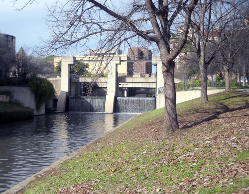
In 1929, an architect named Robert H. Hugman suggested that, rather than paving over the river, the city put in floodgates at the beginning and end of the U-bend and then lower them when flooding was expected. This would force the water to go through the channel and save most of downtown from the flooding.
Then, since the area would be pretty well safe from flooding, Hugman suggested building river-level shops and restaurants in the basements of the buildings lining the U-bend and having a river boat service carrying people from one area to another. The boat plan had one hitch, however. The river current tended to be faster than Hugman preferred owing to a drop in the level of the water both above and below downtown. Hugman designed a limestone dam to be put north of downtown to slow the speed of the water.
The the Stock Market Crash of 1929 hit, followed by the Great Depression. Plans to build what Hugman had called “The Shops of Aragon and Romula,” were put on hold. Work began once the Works Progress Administration was formed in the 1930s. At first, the people of San Antonio were, shall we say, less than enthusiastic about the construction. Hugman’s plans involved paving along the river, and also building limestone bridges over the river. Plants were uprooted so that new landscaping could be installed.
And yet, it all worked out in the end. Hugman believed so much in his vision that he put his own architecture office on the river level. The office is still there today where the bridge takes Commerce Street over the river and the other side of the bridge is the Casa Rio restaurant, the first restaurant put on the River Walk.
The Nueva Street Bridge and Dam, San Antonio, Texas, 2015
In 1987, work began on a tunnel that would take flood waters from a flood control inlet at Josephine Street north of downtown to an outlet at Lone Star Boulevard south of downtown. This opened up a lot more retail, restaurant and recreational space. the flood control tunnel allowed them to add sidewalks and greenspace to the old flood control channel as well, so that one can walk the entire distance from the original River Walk to the farthest north (at the Witte Museum) or south (which I currently believe is at Mission San Francisco de la Espada).*
*It looks to me like if they could just keep it going another three miles or so (as the proverbial crow flies), the River Walk could meet up with Salado Creek and we could eventually have one linear park that leads from the Witte Museum, down to the confluence of the San Antonio River with Salado Creek, then up Salado Creek to Eisenhower Park, then down Leon Creek to the Medina River. Some of these connections, such as the one at Eisenhower Park, are already planned.