
Alex and I went to Comanche Lookout Park a couple of years ago when I was first playing around with the idea of starting a travel blog. San Antonio has such a wealth of parks and I thought that it was a real shame that I never really got out of the Brackenridge/Walker Ranch/Hardberger/Eisenhower/Denman Estate rut that I was in. So I started to research parks and discovered that Comanche Lookout has both geographical and historical interest.
The geographical interest is that Comanche Lookout Park is the fourth-highest point in Bexar County. And since Bexar County is pretty hilly, that means something. The elevation of Comanche Lookout Park is 1,340 feet. That’s nearly 400 feet higher than the very highest point in Cook County.
As to history, the local Native American nations, the Apache and, later Comanche, used the hill as, well, a lookout post, just as the name implies. Later, the Camino Real de los Tejas (not to be confused with the Californian Camino Real), which connected Mexico City to Laredo, San Antonio, and Nacogdoches, Texas went past the hill. That part of the road is known as Nacogdoches Road today. In the 1920s, a man named Edward H. Coppock bought the land that includes Comanche Lookout and he began work on a castle at the top of the hill. He never finished his castle before his death. A later owner razed all but the foundations and the completed tower at the top of the hill. The property was passed from owner to owner for nearly 50 years. The City of San Antonio purchased the parcel in 1994 and converted it into a public park.
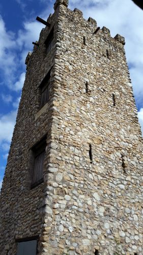
Comanche Lookout Park has 4.55 miles of walking trails and one of those outdoor fitness systems. You know, the “do pullups on this bar,” “hold this bar and do pushups” things. There is a city library on the corner of Nacogdoches and Judson Roads. And, of course, there is the tower (see image), which is surrounded by a fence.
I seem to recall that a large number of the trails are paved, but the path to the top of the hill might be a level 3, and thus unusable by people in wheelchairs without really good upper body strength or a really powerful motorized chair.