This is my first post in WordPress 5.0 and I hope I adjust to this, because it’s making me crazy.
So I just came back from seeing Elton John live (my last-ever chance to do so, unless my dad wins the lottery between now and the end of 2020) and it was awesome. Sir Elton was awesome. The rest of the band was awesome. Ray Cooper* was awesome. The audience was awesome.**
And I fully intend to go on more about this later. Much later. Like, after I get a full night’s sleep and eat at least one full meal, which means it’ll have to wait until after work tomorrow night, probably. Good night.
*I’m one of the people who gave Cooper a standing ovation when he was introduced. Ray Cooper was really, seriously, awesome.
**Both in the sense that it was awesome singing “Ooh-ooh-ooh, ah-ah-ah-ah, Ooh-ooh-ooh” with them during Goodbye Yellow Brick Road and in the “I was in awe of how many people were there.” They were selling seats behind the stage.
Wow. It’s been an exciting few months and as anyone who has read more than, like, two of my posts will know, I’m a terrible procrastinator and the longer you procrastinate the worse it gets. So I’m pulling up a post I started in late July and finishing it up. I may have a sequel tonight (or whenever I get back to posting here).
Remember how sad I was when Tom Petty died? I may have told this story already, but the year I was in eighth grade, we had to write up the lyrics to our favorite songs for the poetry unit in EnglishLanguage Arts. My two favorite songs that year were Tom Petty’s Refugee (from his (Amazon link ahead) Damn the Torpedoes album) and Rock Lobster by the B-52s (from their (another Amazon link) self-titled debut album (I don’t know why it says “import,” but it is (as I write this) only $9 and it’s the only CD of that album I can find on Amazon)). Good luck figuring out the lyrics to those songs on your own (I’m still a little shaky on the bridge of Refugee, to be completely honest). So instead I picked a song that I liked well enough but, more importantly, that I could understand.
But that began my love of The B-52s. I’d never had a chance to see them live, though. When I realized that they were going on tour this summer, I looked it up and the only Texas show I could find at that point was them co-headlining with Culture Club in Grand Prairie. I’ve always liked Culture Club well enough, but not had a burning desire to see them live. But I figured that I’d get three bands (The B-52s, Culture Club, and Tom Bailey of the Thompson Twins as opener) for the price of one this way.
TL;DR version of the review: The shows were awesome. All of the bands gave great shows. The acoustics in the theater, however, sucked.
I (a) don’t have multiple hundreds of dollars to spend on concert tickets at this juncture (though maybe this part of my travel writing will someday be lucrative enough that I will) and (b) didn’t know about the concert until relatively late. As a result, the only tickets I could get were fairly high up in the theater. I don’t know if we were as high in the theater as we were for Weird Al Yankovic (we were almost up against the wall at the back for that one), but we heard Al just fine. If it weren’t for the way I could feel the bass in my chest, I might as well have been watching this concert on television.
After I bought the tickets for the show in Grand Prairie I discovered that the B-52s do have a stop at the Tobin Center in San Antonio. That show is October 24, 2018 :looks at date on post: and I was so upset by the acoustics in Grand Prairie that it pretty much guaranteed that I’d want to see them at the Tobin Center. That’s the sequel I was talking about. Alex has no interest in seeing the B-52s again, so I’m going all by myself to see them in, well, about 14.5 hours from right now.
Grand Prairie is in between Dallas and Fort Worth and so the day after the concert, Alex and I drove into Dallas to visit Dealey Plaza (where JFK was assassinated). I’d been to Dealey Plaza once before, in, I want to say 2005, but Thomas has those pictures, so I took pictures and we got the conspiracy theory version of events from a street vendor. I’ll hopefully be able to put together a post on that visit soon.
6:12 Finally. A damn street name. What does that say? “Easter . . .?” “Eszterhas?” Is it backwards? Is it Cyrillic? Did I have a stroke? OMG.
Wait. It looks like “Eastehy Ter” so let’s look for that. Let’s look for a list of street names. “Easterly Terrace”? That’s got potential. And it’s back near Silver Lake. Is there a big open space like the two ladies at 6:08 and 6:12 are walking past? Yes, there is. Now, let’s look for the street that the 6:08 lady comes down from. I think that’s it.
So, after rewatching 6:08 and comparing it to Google Street View, it looks like the lady comes down Rockford street to Silver Lake Blvd.
Upon further reflection, I’ve found 6:00. Baxter Street. I was looking for steep streets in Los Angeles, and when I found Baxter Street, that seemed likely. And I was able to match up two palm trees and a bougainvillea to the video, so that’s 6:00 starts near Baxter and Apex and heads west on Baxter then 6:04 we continue west on Baxter and then head south on Rockford. Then we cross Silver Lake Blvd and make a left. Then at 6:12 we flip the image backwards (which is why I had so much trouble identifying where we were). This leads it to looking like she’s going north on Silver lake when she’s actually going south. Then we turn don’t-ask-me-what-direction onto Van Pelt and the image is still flipped (the stop sign is backwards). We make a right onto Silver Lake Drive. We follow Silver Lake Drive to the left (I think) and then the right (I guess).
6:20 Now we’re somewhere else. I think. Is this one flipped? Dunno. Let’s find out. I think we’re still somewhere near Silver Lake, since the garbage cans are still the same. I wonder if we’re starting farther down Silver Lake Drive. Yep. We are. And it’s still flipped. This is very disorienting. Silver Lake Drive bends to the right, becomes Redesdale Avenue, and then bends to the right and becomes Silver Lake Drive again. This is where we start. Looks like we’ll be doing this for a while, so before I take a break to watch people walking around the lake, I’ll say one thing. The barbed wire faces inwards. Traditionally, the barbed wire faces towards the ones that you want to keep from climbing the fence. What lives in the reservoir that they’re trying to keep from escaping into the neighborhood?
At 6:39, we finally leave Silver Lake Drive and make a right turn onto Tesla Avenue then another right onto Armstrong.
6:56 Now I really don’t know where we are. We went almost the entire distance around the Silver Lake Reservoir between 6:12-ish and now. Picture a slow, knowing smile creeping across my face. I know where we are now. We’re at the whole reason I started this project to begin with – the Los Angeles River. As I said a couple of quite a few posts ago, on our final day in California, I made Alex go with me to visit the LA River because I heard they were doing amazing things with it. And the only directions I could find took us way out of our way (though it was an interesting trip). When I saw the video for Happy, though, I recognized the bridge we used to leave the river and was going to put those directions in my post on our trip to the river. When I was double-checking to make sure that it was where I though it was, I saw a little tag about visiting the 24 Hours of Happy site and got this bizarre idea to go over the whole video and figure out where everything was filmed. It is now 6:56 am their time and 11:41 pm my time and now it’s time to go to bed.
Pharrell promotion time. I’ve got, like, four things that will give Pharrell money if you buy them, too, and here’s the first. Amazon Associates link this time, since I’ve spent my own money on it: the movie of Despicable Me (the soundtrack will probably be up next).
Note: I am pasting this into the interface (preparatory to scheduling it for midnight on June 11, 2018) and I still cannot swear where we are from 5:00 to 5:35:59. At first I thought it was Griffith Park, but some sites mention that the video was filmed in part at Runyon Canyon Park, but it doesn’t really look like that either, near as I can tell from Google Street View. I guess on Alex and my next trip to California I’ll make him visit Runyon Canyon Park to see if it looks familiar.
==============
5:00. Wow. I’m stumped. We spend a lot of time in a big flat area where the ground has a kind of pinkish cast, like it’s made from pink granite or something. There are towers with what I at first thought were guy wires, but upon further watching seem to be holding up power lines. But there’s not a single landmark or sign* to be seen. There’s a fence with sharp pointy bits on the top. The fence looks kind of institutional and the pointy bits are pointing outwards towards the viewer, so, I don’t know. The Los Angeles Zoo, maybe? A college or boarding school? Boy, Beattie has been walking downhill backwards for an awfully long time. I hope he’s going to be okay.
Now there’s an I don’t know, water tower? A big green tank of some sort, at any rate. What I wouldn’t give for a street sign. A subway station. A McDonald’s.
Okay, now we have a gate. Not a fancy, identifiable gate, no. Just one of those things that they padlock shut to keep you from driving up that street. It’s probably metal but looks like PVC pipe. A chain-link fence. More chain-link fence. Pine trees. Minions.
5:36 Now we’re at Magic Johnson’s house. Even if I’d been to Magic Johnson’s house, which I haven’t, or I could tell where it is, which I can’t, I wouldn’t be saying, “Hey everyone! Magic Johnson lives at . . . “
5:40 Sigh. A residential neighborhood. No way I can. Oh, wait. Is that Vermont on the way up to Griffith Park? I think it might be. Let’s check. Eee. I got it. Now how on earth did I get it? Apparently the “bumps 15 mph” sign is more memorable than one would expect. We start at Aberdeen and then make a left onto Vermont, heading south on the sidewalk along the northbound lanes. Time to enlarge the polygon. We keep walking down Vermont to Hillhurst and then down Hillhurst to Gainsborough, where we make a left.
5:56 Now we’re somewhere completely new, I think. Let’s find out. The street name behind him looks like “Tempe” or “Temple,” which is probably just my brain filling in because I know that there’s a Temple street in LA. There is something that looks like a school or a church up there on the hill behind him, but I’ve only got 40 seconds left, so I doubt I’ll ever figure this one out. The angle just changed and we seem to be at the top of a very steep hill. I wonder what I’d get if I searched for “the steepest hill in Los Angeles. . . .”
*Well, okay. There are a couple of signs, mostly what looks like of the “put your garbage here” and the “don’t climb on this tower” varieties.
==================
ETA: I finally found it. Well, part of it, anyhow. It sure looks to me like the 5:04 dancer passes the spot at coordinates 34.1252253,-118.2820732 in Griffith Park. The posts, the buildings, the fire hydrant, and the bollards all match pretty much exactly. Unfortunately I cannot follow the whole trail because no one has driven/walked it yet and posted it to Google Street View.
I definitely think I’m onto something here. We seem to be following Vista del Valle Drive, but I cannot figure out which direction we’re going. I’ll have to do further research.
I’m paralyzed by indecision here. I’ve decided to link to Kelis’s song Milkshake for my Pharrell promotion this time out, but there are just too many versions of it. Ack!
Okay, so I’m just going to link to the first two that come up. Looks like one is the “explicit” version and the other is the “clean” version. Milkshake by Kelis/Milkshake [Clean] by Kelis.
===============
4:00 Pharrell takes over from where the off-brand Lalla Ward left off on Vermont and the 101.
4:04 We’re somewhere else now. Phone calls are 25¢. There’s a gas station. There’s an escalator. So we’re headed into the subway? That could be cool. Also, Jon Beattie definitely gets the MVP award for heading backwards down an escalator like this. I hope Pharrell gave him a raise. And, well, we actually aren’t anywhere new. We kept going south on Vermont and are now at the intersection of Vermont and Beverly.
4:08 Now I’m pretty sure we’re up at Vermont and Oakwood, at the Shell station (we sure seem to spend a lot of time at gas stations).
4:12 And now we’re even farther north, this time back on the bridge over the 101. Each dancer here is heading south, by the way. Our polygon isn’t getting any bigger here, people.
4:16 We’re in a car now. I can identify neither the car nor the location. We go past a car wash and under an overpass. Wait. There’s a Chevron station and a Quality Inn. More overpasses. A Valero, I think? Another overpass and the words “Tom’s Burgers.” Now I’ve got a 7-11. OMG. I’m sure that if I could find a Chevron, a Quality Inn, a Valero, a Tom’s burgers and a 7-11 in that order, I’d have the place, but what are the odds? Okay, we have an identifiable business, finally. Violet Olga Salon. That puts us on Glendale Blvd and the location of the 7-11 means that we’re going north. And it only took 14 minutes to figure this out.
I take it back. We just turned onto Glendale. Prior to that we were on Silver Lake Blvd. The thing that says “Tom’s Burger” in the video says something about 100 years of Armenian Genocide in September of 2017. The Valero might be a Mobil now?
So now we’re on Glendale and we make a right onto Fletcher and then another right onto Riverside. And now we’re enlarging the polygon. We make a left onto Newell and then another left onto Ripple. We turn left onto Rosanna and go under the Glendale Freeway, which apparently will lead us back to Ripple? Then a left onto Gilroy (this one took me a long time because my brain kept seeing the design on the van as being public art on a cement wall. Once I figured out what it was, I saw a similar van at that turn on Google Street View and knew that had to be the right corner). Then we go under the Golden State Freeway and make a right onto Riverside again. Now I’m really confused because we turn right onto Fletcher, which means that we’re now where we were at the beginning of the paragraph. We then head back under the Golden State Freeway and the past the site where Rattlesnake Park is now, and then over the LA River. You can barely see the river, since it’s now 4:41 in the morning. Then we turn left onto San Fernando and head north (doesn’t this sound familiar? Let me guess. We’re going to make a left onto Glendale in a minute).
4:44 That’ll show me for making assumptions. We’re back on foot, with a dancer in a longish skirt and a sparkly blouse in the middle of the street . . . somewhere. Are we in a park? A wealthy-enough residential neighborhood that the houses are set really far back from the street? There’s a park-looking garbage can in the middle of a line of those little wooden bollard-type things that mark the sides of roads in parks. Like these. At 4:54 or so, we go around the other side of her so that she’s no longer backlit and can see the lights of the city in the distance, so my guess is that we’re in Griffith Park.* About damn time, if you ask me. I hesitate to enlarge the polygon unless I’m absolutely certain, which I probably won’t be until it gets lighter. Well, as of 4:59, it’s almost light enough to see, but there’s still not enough to go by to enlarge the polygon. You can see a transmission tower and guy wires behind the final dancer so maybe we’re up by the Hollywood sign?
At 4:59:59 our polygon is 13.76 square miles, meaning that we’d now need 182 Hours of Happy to cover the entire city.
*I think I’m wrong about this. Several months later I’m still pondering. In articles about the video I see more mentions of Runyon Canyon Park than of Griffith Park, but I have seen both mentioned. It may be that the next hour, much of which is spent in a park, is spent partly in each of the two.
Pharrell-promoting Amazon link time. I searched for his name on Amazon and came up with a children’s picture book of Happy with the song lyrics illustrated with pictures of kids. The Amazon preview looks cute, so this is my choice for today’s link: Happy by Pharrell Williams
============
I hadn’t decided to make these into blog posts yet, so there’s some big gaps here. We spend 1:56 to 2:23:59 in the American Legion Hall.
2:24 East on Selma from Highland to the block between Wilcox and Cahuenga then south on Cahuenga to Sunset and east on Sunset to Gower
2:56 Sunset and Hillhurst* then inside the Vista Theater**, which sits where Hollywood Boulevard becomes Sunset Boulevard then inside the Caffe Vita cafe then back out onto the street about halfway along that block. We next start at the other end of the block, down by Fountain, and head back up northwest to the Vista and then south on Virgil then back up to where we left off after Caffe Vita (the restaurant that’s there, El Chavo, is being torn down or otherwise renovated in Google Street View’s pictures from June of 2017).
3:20 It looks like we might be somewhere else. I can see a Chick-Fil-A in the background and the dancer passes a round yellow sign with a smiling mouth in the bottom half. Never mind. We’re going back up Highland now, on the other side of the street, and then we make a right onto Selma on, again, the other side of the street.
3:24 Remember the Vista? We’re here on yet another side of the street now. I think we’re going west on Sunset. I take it back. We’re heading northwest on Hollywood. I think. Yes. Definitely northwest on Hollywood. The Auto Zone should be on our left. There’s the U-Haul on our right. We are going to leave this part of Los Angeles someday, right?
3:32 Farther northwest, starting near . . . Rodney Drive?, this time on the other side of the street. We have a rhythmic gymnast this time, which is a nice change. Then when we reach Vermont, we make a right rather than crossing the street. We get to Vermont and Franklin, then turn around and head right back up Vermont. Palermo was open for breakfast on Saturdays and Sundays in 2013. That’s good to know. And no, I haven’t been to Palermo. Neither the city nor the restaurant. It’s just that it’s almost 4:00 in the morning 24-Hours-of-Happy time and the area we’ve covered is bound by a polygon 5.93 square miles in area. At this rate we’ll need 338.6 Hours of Happy to cover the whole city.
3:56 Where are we? No clue. I can see a McDonald’s in the background. That oughtta narrow it down. Wait. There’s a 76. I wonder if we’re back on Vermont. Nope. Apparently not. No. Wait. Yes. We are back on Vermont just south of where we started out. Our dancer, who looks kind of like a young Lalla Ward (though that may be because I have a head cold and have been at this for two days now), just danced across the entrance to the northbound 101. Yay! With 10 seconds left to go.
And that ends the first four hours of Happy and our polygon is now 6.43 square miles. We now need only 312.3 Hours of Happy to cover the whole city.
I take it back. I forgot about the Alexandria Hotel and the block between 7th and 8th on Hope. So we’re up to 11.42 square miles. So 175 Hours of Happy.
*This one started out as “IDEK. There’s an Auto Zone and a brick wall and the word “Food” in neon”
**This is where Pharrell makes his 3:00 appearance and my original comment is “How many Egyptian-themed movie theaters are there in Los Angles, and why aren’t any of them turning out to be the right one? The word “family” seems to be written above the marquee.”
Okay, here’s the deal. I don’t want Pharrell to be all, “Hey, this lady’s using my work as a naked cash grab!” But then I don’t want to avoid the cash grab completely. But, it is important to me that Pharrell at least have the possibility of making a bit of money off of this. So, every post will have an Amazon link to something that will potentially put money in Pharrell’s pocket at the beginning. If it’s something that I’ve spent some of my own money on (the DVD of Despicable Me, for example), I’ll link it through my Amazon Associates ID. If it’s not (Britney Spears’s Britney album, which has the song I’m a Slave 4 U, which Pharrell wrote and produced, on it), I’ll post the naked Amazon link. I’m currently toying with buying Daft Punk’s Random Access Memories album, but haven’t decided yet. I guess we’ll find out if I buy it or not when I get there.
So I guess we’ll start with Britney, since it’s on my mind.
I hadn’t decided to do this as blog posts at first, so these first two hours are just my notes on where we go and what we see. Things get chattier and more detailed in future hours.
Midnight Mobil – Vermont at Melrose
12:40 – 4000 Fountain east to Hyperion then north to Glendale then south on San Fernando to Fletcher then northwest on Fletcher to Glendale to Rowena (?)
12:56 between 7th and 8th on Hope
1:00 a.m. Beats me. We’re indoors and the only words I can read look like maybe The Plump Gander? The Palm Court? That looks like a distinct possibility. There’s a Palm Court Ballroom in the old Hotel Alexandria in downtown LA that looks a lot like the room that Pharrell is dancing around in. If only I could see the ceiling. . . . Well, until I find something better, that’s my decision.
1:04 Hollywood American Legion Hall*
1:12 Outside American Legion Hall heading south on Highland to Mel’s Drive In
1:32 Back farther north on just south of Highland and Johnny Grant then west on Hollywood boulevard to Sycamore then back east on Hollywood to Highland and back south on Highland again to Hawthorn
1:56 Back at the Hollywood American Legion Hall, apparently.**
*2035 N. Highland
**You’ll see the term “apparently” a lot in these posts.
Note: I wrote this the night of April 27, 2018. There was some kind of maintenance thing going on, so I was unable to post it then. It’s April 28, 2018 right now and I’m trying to dig up something usable from the few photos I took at the concert. I prepared my regular camera in hopes that it would take better pictures than my cell does, and then left the camera in my car. If I come up with something I like I’ll edit this later.
Alex and I went to see Weird Al Yankovic at the Tobin Center last night. The last time I saw Weird Al live was in 1987, when he was touring with the Monkees. And even though he was “pulling out none of the stops,” to quote the back of the tour t-shirt*, it was still an awesome concert.
I’m behind on his songs, so I only knew maybe one in three (Alex didn’t know any), but I was able to follow most of the ones that I didn’t know. I was really glad to be able to hear Bob live (my other favorite of his from the ones he did was One More Minute, which he did in 1987, as well).
The straight cover he did last night was Viva Las Vegas and the full parody was The Saga Begins. He also performed Jackson Park Express, which I hadn’t heard yet, despite having bought the Mandatory Fun album. I figured he probably did Jackson Park Express every night, but looking back at the set lists, I find he hasn’t. It’s a really long song, nine minutes, but I found the song engaging so the time seemed to fly by.
An interesting thing I discovered once I got home. Al described some of his “style parodies” as coming from a “what-if” game. And one of the songs he introduced this way was Dog Eat Dog, which he said was “what if I were David Byrne and I’d just gotten an entry-level job in an office” or words to that effect. David Byrne is, as I write this, decompressing after having performed at the Tobin Center. I wonder if Al chose Dog Eat Dog specifically because he knew that Byrne would be playing the same stage the next night. . . .
*I think he pulled out one of the stops (maybe even two). There were flashy light things going on (which made it difficult to get anything like a photograph of him from the nosebleed seats) and he had a smoke machine.
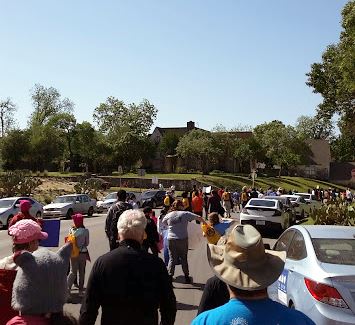
On April 14, 2018, San Antonio held its second annual March for Science. The 2017 march wasn’t as well attended as I would have liked and the 2018 march had, from what I could tell, even fewer people. I haven’t yet been able to find any official numbers of attendees for this year, though.
Some of the marchers. You can probably see what I mean about the sparse attendance.
We started out at Thomas Jefferson High School, the third-oldest high school in the city (the first two were evidently the Main Avenue High School (which is where CAST Tech High School is today) and Brackenridge High School (which is on Eagleland in between St. Mary’s and the San Antonio River)). A large number of famous San Antonians attended Jefferson High School including the Castro brothers — Joaquin (a US Senator) and Julian (the former mayor and who was Obama’s HUD secretary) and two Nobel laureates — Robert Floyd Curl, Jr (namesake of Floyd Curl Drive in the Medical Center area? Perhaps) and William E. Moerner.
Jefferson High School has a lovely building, which is on the National Register of Historic Places.
Jefferson High School. I actually like this one pretty well.
The Motorsport team from San Antonio College was there showing off the car that they were entering in the Shell Eco-Marathon in East Petaluma, California.*
The opening remarks were given by Ron Nirenberg, the current mayor, and then we marched down to Woodlawn Lake Park, sort of buzzed the park a bit, and then back to the high school. The march didn’t get much attention in the media, so only a couple of people came out to watch us (we also were watched by, and waved at, some roofers who were working on one of the houses in our path). I listened to the speech by the faculty sponsor for the Motorsport team, took some pictures of the building, and then hung around until I started to see people leave.
It was a very enjoyable march. It’s nice to get out with people who share the kinds of interests that I have. I just wish that there had been more promotion of the actual march, so that more people would have turned out for it and maybe we would’ve gotten more spectators.
*They won first place in a design award and fourth in the actual race.
Okay, let’s cast our memories back. Back, back, back. Farther than that. Okay, are you to 1978 yet? If not, we’ll wait.
Are we all here? Jimmy Carter is in the White House (I’m a big fan). David Berkowitz is tried and sentenced (I am a bit of a true crime geek). We had three popes, including the eerily prophetically named John Paul I, who really did put the “I” on his name (also a religion geek). And the top-grossing movie for the year? Grease.
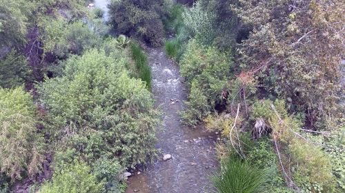
If you’ve seen Grease, you’ll probably remember the drag racing scene. Remember the street they’re racing on? That’s not a street. It’s a river. The Los Angeles River, specifically.
There was catastrophic flooding along the Los Angeles River in 1938 and to fix the problem, they completely destroyed the river’s ecosystem. They dug the river deeper and widened it and covered the whole damn thing with concrete, as if that doesn’t add insult to injury.
In past visits, I’d seen the river occasionally, and it was just as heartbreaking an eyesore as you’d expect. I couldn’t believe that there ever had been a healthy river there.
In recent years, however, I’d been hearing that they’d been working on restoring the ecosystem. I’d heard rumors that there was enough water in some places that people were actually kayaking. This, I wanted to see with my own eyes. I spent quite some time trying to figure out exactly where the improvements had been made and how to get there. Finally I found an article in the Los Angeles Times giving directions that involved parking by the tennis courts in Griffith Park and walking behind the soccer fields. There, you’ll find a bridge over the Golden State Freeway which will lead you to the river. So, we did just that. It certainly was an experience, and on an early Monday afternoon in late July there aren’t a whole lot of people out and about, which made Alex very nervous. We got some fantastic pictures and got to watch an actual blue heron in the water of the river.
After a few blocks, Alex had enough. So we took what turned out to be the Alex Baum Bicycle Bridge back to Los Feliz, took Los Feliz back across the 5 and returned to our car. I’m glad I got the chance to see the revitalization of the river, even if it was kind of creepy and deserted, and I hope to get a chance to explore more (maybe on a weekend when there will hopefully be more people there) on future visits.
Also, coming back on the bridge is why I began my 24 Hours of Happy project. I was watching the video for Happy and noticed that Pharrell is on the Alex Baum Bicycle Bridge at one point. The end of the video directed me to the 24 Hours of Happy site and then I found the individual hours on Pharrell’s iamOTHER channel at YouTube, and it was all downhill from there.
Look at that. From this angle it almost looks like nature. And someday it will hopefully look completely like nature from all angles.
But back to our final day. Traditionally when someone from our pharmacy goes on a trip, they bring something back for everyone else in the pharmacy — magnets, food, pens, whatever. I hadn’t found anything yet, so I looked up souvenir shops and found that most of the best ones are in Hollywood. We hadn’t been to Hollywood yet on this trip, so we figured why not?
We found a parking lot not too far from Hollywood Boulevard and hiked for maybe a quarter or a third of a mile. But what a quarter or a third of a mile! We walked down the Walk of Fame looking at all of the names and watching the people looking at all of the names. I noticed, by the way, that Betty White’s star and that of her late husband, Allen Ludden, face each other, which I thought was sweet. We also went past the establishment formerly known as Grauman’s Chinese Theater. You may be familiar with Grauman’s. It’s the place where all of the actors’ hand- and footprints are in the squares of the sidewalk. I dragged Alex from actor to singer to director just agog and I managed to restrain myself and only take one (not very well framed) picture of Bette Davis’s square. Finally Alex dragged my attention to the task at hand and we continued to the souvenir store. I resisted the temptation to stop by again on our way back to the car, but we needed to get on our way to the airport to return to Texas.
We got our souvenirs and made it back to the airport in plenty of time for our flight. Unfortunately we were seated on the “wrong” side of the plane, by which I mean the side that faced out onto the ocean. As it took off, the plane circled around the Palos Verdes Peninsula, and from that side of the plane I could have maybe gotten one last picture of Cabrillo Beach, the lighthouses, Seal Beach Pier and the Queen Mary. Well, now I know. We need to be on the left side of the plane on our flight back next time.
And there will be a next time. Not in 2018, and maybe not even in 2019, but someday.