San Antonio Parks: Cathedral Rock Nature Park

Okay, so you turn off of Grissom Road into the little parking lot at Cathedral Rock and see a little play area and a little picnic pavilion.

Cathedral Rock Playground, 2018
The playground at Cathedral Rock taken from a creative angle again because I didn’t want to risk getting any of the kids playing nearby in the picture

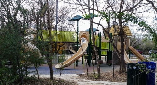
You walk a little farther and find this:

Cathedral Rock Park path
A path at Cathedral Rock Park.

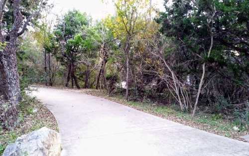
And then a little farther on you find this:

Cathedral Rock Park Map
A map of Cathedral Rock Park

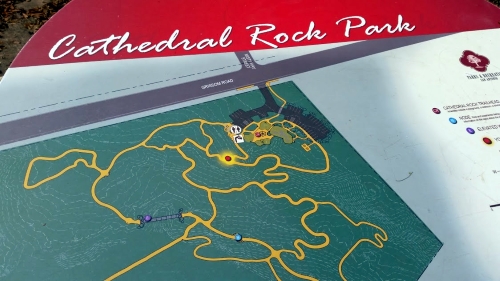
And you realize that there’s quite a lot of park to explore here. I focused on the corner of the map for the picture above because Cathedral Rock Park is also a trailhead for the Leon Creek Greenway and the Greenway takes up most of the map.

I took a lot of pictures here and don’t know how many I’ll use. I think there are actually more paths at Cathedral Rock than are pictured on that map, because I was following the map on Pokémon Go rather than using that map and almost all of the paths that they had on the game were there in the park (the only exception I can think of is I think it might be that loop there in the upper-left-hand corner looks like it comes straight back from the lower-left part and rejoins the main path in kind of a reverse D-shape rather than that lasso kind of shape it has on this map).

Most of the paths have the San Antonio trail levels assigned to them, where Level 1 and 2 are usable by people in wheelchairs and Level 3 is usable by really incredibly fit people in wheelchairs and Level 4 is probably not usable by people in wheelchairs. Some of the signs showing which level applies to which paths were in pretty bad shape when I was there and could use some replacement signs.

Finally, why Cathedral Rock? Beats me. The park itself is mostly level with the occasional scattered bits of limestone. Once you get to the greenway, though, you find this:

Cathedral Rock?
Is this “Cathedral Rock”?

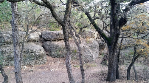
Which is way more impressive than it looks in the photo. Maybe if the deer had stood there while I took my picture rather than freaking out and running away it’d look less uninspiring.

Now I guess it’s time for a gratuitous Amazon link. I looked at books about limestone, since the rocks of what I assume is Cathedral Rock are limestone, but, eh. So I went back to the same link as I used before and dug up Hiking the Pacific Crest Trail: Washington: Section Hiking from the Columbia River to Manning Park by Tami Asars. I’m not planning on going on the Pacific Crest Trail anytime soon, but the picture on the front sure is pretty and it has 4.9 stars (out of 5) so why not?

Greenway Walk Progress

This isn’t an official South Texas Destination — yet.  But it will be eventually, so I’m categorizing it as one.

As I believe I’ve said before, my plan is to eventually visit the entire Howard W. Peak Greenway Trails System, which, since they’re still building more trails, is a pretty long-term project.  I also hope to walk the entire River Walk, but that’s a different project entirely.

I now have walked the Leon Creek Greenway almost from the Valero Trailhead at 1604 to the Leon Vista Trailhead.  I estimate that that is about 7 or 8 miles of walking.  When I say “almost,” I have missed two spots.  One, from Fox Park northwards to just north of the Northside Independent School District bus parking lot, will be pretty easy to knock out if they ever finish the construction on Hausman Road.  Just getting to the parking lot for the Fox Park Trailhead is a challenge at the moment.

The other missed section will require a chauffeur.  I walked south from the Buddy Caulk Trailhead and north from the Leon Vista Trailhead and in the time allotted to me, I missed meeting these two paths up by about two blocks.  I will need someone to drive me to the closest street to that area to drop me off, then that person will need to pick me up twenty minutes later.  This will be something that I will leave to the very end of the project.

Next up will be from the Mainland Trailhead (behind the Bandera Road Walmart) north to the Leon Vista Trailhead and then south from the Leon Vista Trailhead as far as I can go.  I don’t think I can make it all the way to the next parking lot, which looks like it’s a couple of miles away.

I’d better load more 1880s National Geographics onto my phone for this one.

I Think I’ve Talked About the Howard W. Peak Greenway Trails System Before . . .

But I think that the Howard W. Peak Greenway system may end up needing its own tag.

This is because I hope to eventually walk the entire thing.  Not at once, though that would be cool to take a few days to do.  And it would take a few days, because at the moment, the brochure (Warning! This link leads to a PDF!) says that there are currently 47 miles of trails.  My current record (since I’ve been using the pedometer on my phone) is 12 miles in one day.  So if I were able to keep that pace, it would take me, well, about four days to walk the whole thing.

Eventually, the greenway system will ring pretty much the entire city from the Medina River in the south to Leon Creek in the west, and then the Leon Creek Greenway will meet the Salado Creek Greenway up at Eisenhower Park (just south of Camp Bullis) and then the Salado Creek Greenway will go down the east side of the city.  The Riverwalk runs down the center, but it will eventually connect to the Medina River. There don’t seem to be any plans to make the Leon Creek Greenway meet the Medina River Greenway, nor the Salado Creek Greenway with the Riverwalk.  It would be fantastic if they did, though, because then one could just start anywhere in the system and reach any other part almost without ever going up to street level.

And I hope to walk all of it eventually.

So far, I’ve done the middle part of the Salado Creek Greenway, the far northern part of the Leon Creek Greenway, and, just at a rough guess, the northern 70% or so of the Riverwalk.  So I have my work (or my walking, technically) cut out for me.