24 Hours of Happy: 3:00 to 4:00 p.m.

And, today, to give Pharrell Williams some money, we have his 2014 album G I R L. (and also some non-breaking spaces I wonder if they worked?)

3:00 pm Ah. Okay. This is the part with the choir from the video. We stay inside the church for a while, finally emerging into the afternoon sunlight at around 3:13. We head north on Marengo until 3:16.

3:16 We’re somewhere else. Again. Are we still somewhere in Pasadena? Are we back on Vermont? Dunno. It looks like a residential neighborhood with broad streets. I can see a street name. It starts with an “A.” “Algernon”? “Algonquin”? “Aloysius”? No parking. Bike route. A guy doing The Pony this time. Another illegible street name. Pine trees.*

3:20 Wow this guy’s backlit. It’s almost like one of my photos. Wait – there’s a sign. Let’s go back. It might be a hospital sign I can see “Main Entrance” and “ICC.” Another agave. There’s a big building with a tile roof in the background.

3:24. We’re not in the same place, but it sure looks like the same big building there. From this angle it looks like maybe an apartment building? Yet another illegible street name. And another – no, wait. Does that say “Mt. Pleasant”? Let’s try that out.

This could be it. We start out on Campus Road and Alumni (that’s our “A” street name) near Occidental College.** We follow the street (which is lined with pine trees and has a sign that says “ICC” on it) and just before we make a left onto Stratford, we can see a large building with a tile roof behind us. Mt. Pleasant makes a T junction with Stratford.

3:32 We’ve moved again. I think. Did we move at 3:28? No, I think that’s where we left off. We cross Avenue 49 in the right place. The background matches. The fences match. That’s the same mailbox.

That flowering shrub is the same.

So that house on the corner must have really changed.

I guess that is the same house. Amazing what a coat of paint and a deck will do.

The train of her wedding dress will be really grubby after dragging it along the street like that.

Oh! And we’ve turned onto Avenue 50 and are headed southeast. Then we make a left onto Meridian. I wonder what this bride’s story is. Is she a model or is that her wedding dress. Pharrell got married in 2013, didn’t he? Is this his wife?

No it doesn’t look like her. And that’s doesn’t look like what his wife wore at their wedding so probably not.

3:36 Rush hour must be starting or something. Those vehicles are driving right past that young woman (and, presumably, the entourage walking ahead of her). I wish I knew where in the block she was right now. ‘Cause there’s something in the middle of the sidewalk there and I wonder if it’s a permanent fixture or what. Oh, wait. We’re at the end of the block. And I don’t see anything on the sidewalk there, though it could be behind one of those cars***.

We cross Avenue 51 and I really need to go to bed. We’re hoping to go state parking tomorrow.

(the next day)

We make a left onto Avenue 52 and we might not have time to go state parking today. We both overslept.

We eventually find ourselves making another right back onto Stratford. Our next dancer is wearing high-heeled footwear of some sort (we’re still pretty backlit here, but I think they’re boots) and she looks a little unsteady on her feet, like she has either walked or danced in these heels but not both together.

3:48 We’re on a sidewalk. Are we still on Stratford? I see a steeple-looking thing there. Let’s see if I can find it on Google Street View. Yep. There it is. I wonder what it is. I know how to get back here from there.

It’s the Iglesia Adventista de Highland Park. It’s kind of a cool-looking building. Their Facebook has the name in English (Highland Park Seventh Day Adventist Church) but the information on the page is all in Spanish.

Oh, I can hear my late mom now. “She’s not dancing. She’s just posing.” We get the occasional dance step from this young lady, but overall, it feels more like she thinks she’s a model in a fashion shoot than a dancer in a music video. We continue following Stratford after it jogs slightly north at Avenue 55. How far back do these numbers go? Is there an Avenue 1 somewhere? Looking it up, the “North Avenue #” names only look to go as far back as 16.

3:52 We’re leaving Highland Park and now we’re at a cemetery? I wonder what cemetery we’re in. It’s not Forest Lawn Hollywood Hills, I don’t think. Time to hit Google Image Search.

*I still don’t know where we were, months later.

**Alma mater of Ben Affleck, Matt Damon, and Barack Obama.

***for varying definition of “cars.”

24 Hours of Happy: 2:00 pm to 3:00 pm

2:00 to 2:25-ish I really thought that we were going to spend another hour inside Union Station. Then, around 2:25, the dancer walks out the front door of the station and . . . keeps going. We start out on Alameda and head south. We cross Alameda at Temple.

What temple is this street named for, I wonder. Oh, apparently it’s not a temple, but a Temple. Jonathan Temple, to be exact, a rancher who lived in the area and was the first mayor of Los Angeles. No relation to Shirley, I guess.

Are we going to go down Temple? It looks like it.

And we start to go northwest on Temple.

2:44 Now we have three guys . . . somewhere. You can see an underpass and a pink and gray building behind them. We passed a pink and gray building on Temple, but this one looks less pink and more gray, so I don’t think it’s the same one, but I’ve been wrong before.

Maybe this is the parking garage from 9 am? Judging by the public art piece there by the underpass, yes, it is the Grand Avenue parking garage again and we’re heading northwest on 4th Street. At the corner of 4th and Hope, we make a right onto Hope.

2:48 4th and Hope was nice while it lasted. We’re somewhere else now. I see a sort of plaza with trees. I see buildings. I see a bicycle lane. I see Pharrell in Union Station (I goofed and restarted the video instead of pausing). There’s a bus shelter and a blue-and-white sign not entirely unlike the sign for Good Samaritan Hospital. Are we back over on that side of town?

Ah-ha! The words “Federal Building.” That should help us narrow it down. Are we back on Temple, maybe? A lot of the governmental buildings are out there.

We’re now on Los Angeles Street again, this time between Temple and Aliso. The blue sign is for the Los Angeles Mall. We cross Aliso and then go over the 101. Well, the dancers do. I somehow click in the wrong place on the Street View and end up on the 101.

Okay, I’m back on Los Angeles.

We continue north and pass a lady with a doggo. The dancer stops to pet the pupper and we see a man arrive with two more dogs in a stroller. There’s a lot of greenery nearby, so I wonder if there’s a dog park near where we are. So I look it up and we’re near Father Serra Park, which doesn’t seem to have a dog park.

In fact, Los Angeles has only nine dog parks that I can find. San Antonio currently has 11 dog parks. That’s one dog park per 441,000 Angelenos and one dog park per 136,000 San Antonians. Los Angeles had better get on the ball.

We cross Los Angeles and guess what we see in the background? If you didn’t guess Union Station, you’d better keep guessing until you do. Because that looks to be where we’re headed. Union Station is sure a pretty building and is framed very attractively at around 2:55:45 or so. I just kind of wish we’d spend some time somewhere else. Particularly since we’re burning daylight here.

I missed a day during the 2-2:59 hour because I had some kind of digestive thing. It may have been my motion sickness cropping up, it may have been something I ate, it may have been an eight-hour bug. But either way, watching Beattie look up into the sky after each dancer and then back down at the next one was making my nausea worse.

2:56 Where are we going to start the 3:00 pm hour? There’s a sign for California State Route 110 and the building there on the right sure looks familiar. Have I seen it in real life or in this video or does it just have one of those facades?

More building and our dancer (a) is being photographed from an awkward angle or (b) has a little bit of a limp.

Okay, we’ve left Los Angeles proper now, I guess. The building is the First Baptist Church of Pasadena. And it looks like the Google Street View car went through this area at night during a blackout. Never mind. I was in Pasadena Texas and not Pasadena California. That would explain the darkness (if the car did go through that area at night). There aren’t a lot of streetlights out that way, I guess.

So we start out on Marengo in Pasadena and make a left onto Holly. I wonder what that building behind the dancer is. Google Street View isn’t helping (though there must be a field trip to whatever this building is, since there’s a school bus parked outside), so we’ll use Google-Not-Street-View. According to the old school two-dimensional map, the building is the Pasadena City Hall. Also, according to the map, we’re just a stone’s throw from the Colorado Blvd. Bridge.

Looks like we’re going into the church now. I wonder why Pharrell is indoors for so many of his top-of-the-hour segments.

2017 California Trip — Our Fifth Day in California

Our fifth full day in California, we left the Pasadena/Los Angeles area once again to visit our annual national park. This year, we went to Joshua Tree National Park (which is another topic to spend an entire post on). And my bank did not like this day, like, at all. You see, I forgot to tell them that I was going to California and the algorithm was able to cope okay with expenses in Los Angeles, Burbank, Pasadena, San Pedro, Malibu, and so on. For some reason, however, it couldn’t cope with my buying gas in Morongo Valley or a t-shirt or pretzel rods in Twenty-Nine Palms. Fortunately my debit card went through for all of those purchases, but when I got home, I had an email from my bank asking about it. And, yes, it was from my bank. I called the phone number on the back of my debit card.

We actually got out reasonably early, at 8:00 in the morning, though I had hoped to leave at 6:00 or 7:00. We stopped at the Walmart in Glendora for the only concession I made to the fact that we were going to spend the day in the desert. I bought — and then actually applied — a fairly high SPF (or whatever they’re calling it these days) sunblock (spoiler: I also did kind of a lousy job and ended up with a streaky, blotchy sunburn).

We then headed off to Joshua Tree. After a bathroom stop at a rest stop and stopping in Morongo Valley for gas, we arrived at Joshua Tree about three hours later. This meant, of course, that we were in the desert for the hottest part of the day, and most of the animals (which weren’t as stupid as we were) were hiding out. We did see one coyote just outside the park, though.

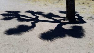
Joshua tree shadow
The shadow of a Joshua tree in, well, Joshua Tree.

We spent four hours at Joshua Tree and then headed back to Los Angeles. After a stop at Walmart in Redlands for a restroom and a pair of nail clippers (I left mine in Texas), we had dinner at an H. Salt, Esq. Fish and Chips in San Bernardino. My folks and I used to eat at an H. Salt (maybe in Hammond, Indiana?) when I was a kid and I hadn’t been to one since Thomas and my 1996 trip (we ate at the one that apparently used to be in Oxnard). The restaurant was kind of empty, but the couple who seem to run the place make the fish to order, so it was fresh out of the fryer when we got it. The restaurant was so dark that we went outside and ate in the rental car. There was a wildfire (a small one, as it fortunately turned out) nearby, so Alex got to watch the planes put the fire out while we ate.

We headed back to our hotel. I fell in love with the bridge that takes Colorado Boulevard over the Arroyo Seco in Pasadena, so Alex and I went around the long way to try to get some pictures of the bridge at night. My phone really doesn’t like to take nighttime pictures and adding motion to the mix doesn’t help at all, so they came out blurry.

Blurry Colorado Street Bridge photo
See what I mean?
Picture by Alex Ogden

We took a few pictures the next day as well, and you can see the bridge in them, but I’m still not totally happy. On our next trip, we plan to actually drive that road and take some pictures of the bridge from the bridge. Ooh! Apparently they have a biennial festival actually on the bridge itself. So if we go back in 2020 (no way we can make it in 2018 unless my dad wins the Lottery), maybe I can get pictures of the bridge while actually walking on it. That’s a definite possibility for the future.