
The drive back to Salt Lake City from Jensen took a bit longer than Google Maps said it would. This was at least partly due to the fact that I was so over the seats in that car.
Once we arrived back in Salt Lake City, I had three goals: 1. to see the state capitol building (and, at one point, I could have crossed a moon tree off my list, but it is dead now); 2. to see City Creek, which was the water source for the early city (and still supplies water to the city today); and 3. to make it back to the airport in a timely manner.
And I achieved all three.
The trip to the capitol building took us up State Street (which makes sense), which eventually becomes one very lane going uphill. It was near the end of the work day (around 4:30 or so), so I figured that most traffic would be headed away from the capitol. I’m not sure why so many cars were headed towards the building at this time of day, but the road was very congested. This was not my favorite part of our trip, and made me wish we had had a little more time and energy on our first day in Salt Lake City to hike up the hill to the capitol. The view of the capitol building once you emerge from this narrow street is very impressive, I’ll give it that.
Once you reach the capitol, you find a street, with the understandable name of “Capitol Street” that makes a circuit around the building. Due to the congestion we didn’t even attempt to make a left and instead just took a right turn. Along the eastern side of the capitol is a very small parking area, so we parked and I got out to take pictures. There was no time to go inside the building.
It was so late at this point, that I despaired of being able to see City Creek until I looked at my phone and noticed that the creek went right past the spot where we were parked. The parking area is at the very edge of City Creek Canyon. So Alex stayed by the car and I took the winding path down into what turned out to be Memory Grove Gardens.
At first, I have to admit that I thought that Memory Grove Gardens looked like a cemetery. I was unaware of the name of this plot of land at this point, but even the name sounds kind of cemetery-like. The path ended at a replica of the Liberty Bell. As I looked around a saw several marble monuments that looked more than vaguely like graves to my eyes.
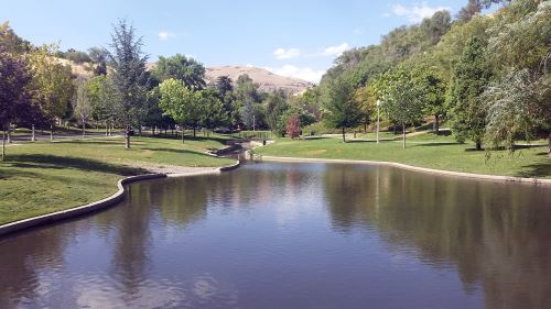
I spent quite a bit of my childhood visiting a great-aunt and great-uncle who lived down the street from a cemetery, so I’m no stranger to spending time in cemeteries. I thought it might be disrespectful to take pictures, though. Then I noticed some people walking dogs and decided that if it’s okay to walk dogs, it’s probably okay to take pictures there.
I think I saw some kind of sign indicating that this was a park at this point. I’m trying to remember (it was two and a half months ago and the Google Maps car has apparently not been along Canyon Road down there yet). I think the sign indicated where the off-leash area for dogs stops. So I got some pictures of the park, the creek, and the walls of the canyon and went back up to the car. I had been down there for a while, and Alex was about to come down after me.
We got back in the car and filled our gas tank at a very small gas station down the street from the Temple and then headed back to the airport. And even with the late start and everything we still got there in time to recharge our phones before we got on the plane (I also caught a Ponyta at the gate).